Last updated: July 10, 2024
Article
NPS Geodiversity Atlas—Monocacy National Battlefield, Maryland
Geodiversity refers to the full variety of natural geologic (rocks, minerals, sediments, fossils, landforms, and physical processes) and soil resources and processes that occur in the park. The NPS Geodiversity Atlas delivers information in support of education, Geoconservation, and integrated management of living (biotic) and non-living (abiotic) components of the ecosystem.

Introduction
Monocacy National Battlefield (MONO) is located approximately 5 km (3 mi) south of Frederick, the second largest city in Maryland, and near the Baltimore–Washington metropolitan area in Frederick County, Maryland. Originally authorized as Monocacy National Military Park on June 21, 1934, the park unit was reauthorized and redesignated on October 21, 1976 (National Park Service 2016a). Encompassing about 666 hectares (1,647 acres), MONO was established to commemorate the Battle of Monocacy of the American Civil War and preserve the breastworks, earthworks, walls, and other defenses used by the Confederate and Union armies. Regarded as the “battle that saved Washington”, the Battle of Monocacy was fought on July 9, 1864, as a small band of Union soldiers delayed a Confederate advance on the nation’s capital at Monocacy Junction in western Maryland. Union forces attempted to burn all bridges crossing the Monocacy River, which successfully slowed the invasion of Washington D.C. and provided sufficient time for General Ulysses S. Grant to send reinforcements to the nation’s capital, ultimately preventing its capture. The core battlefield consists of six historic properties, including the Best Farm (L'Hermitage), the Worthington Farm, the Thomas Farm, the Baker Farm, the Lewis Farm, and the Gambrill Mill; many of the historic structures on these farmsteads existed at the time of the battle (National Park Service 2015a).
Geologic Setting
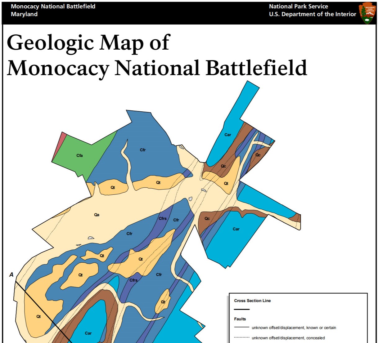
Monocacy National Battlefield is situated in the Frederick Valley of the Piedmont physiographic province, an area defined by parallel valleys and ridges that played a major role in the military strategy of the Battle of Monocacy. Natural features such as ridges, low valleys, shallow fords, undercut banks, and other subtle topographic expressions were utilized by troops for defense and transport routes (Thornberry-Ehrlich 2008b). The oldest bedrock underlying MONO consists of metamorphic rocks of the Neoproterozoic–Cambrian Ijamsville Phyllite in the easternmost sections of the park. The Ijamsville Phyllite consists of phyllite, phyllonite, and minor slate that are juxtaposed against younger units along the Martic thrust fault (Southworth 1999; Southworth and Brezinski 2003). Several Cambrianage formations are mapped within MONO and include the Araby Formation and the overlying Frederick Formation (Rocky Springs Station, Adamstown, and Lime Kiln Members). Prominent ridges located along Monocacy River both north and south of Bush Creek are comprised of sandstone and phyllitic shale of the Araby Formation, while low-lying valleys are typically underlain by rocks of the Frederick Formation (Southworth and Brezinski 2003).
Geologic Features and Processes
The rocks of central Maryland reflect the powerful tectonic forces responsible for the Appalachian Mountains. Precambrian gneiss, metavolcanic rocks, and younger (Paleozoic) quartzite and phyllite underlie the hills visible to the west of Monocacy. The entire region was compressed during three separate tectonic events, the Taconic, Acadian, and Alleghenian orogenies. Following this compression, a series of fault-bounded extension basins, such as Frederick Valley, developed in the Triassic. These basins filled with sediment shed from the mountains.
The park is in the Frederick Valley and is underlain by thick Triassic sediments just east of the Blue Ridge. The downdropped Frederick Valley is bordered on the west by a large normal fault.
Military Geology
Geologic processes give rise to a landscape composed of rock formations, hills and valleys, waterfalls, and wetlands. This landscape played a prominent role in the movement of troops and battle locations during the Civil War. Local geology dictated the placement of bridges, fords, and railroads, which in turn informed military strategy. Today, geologic processes continue to develop a landscape that influences human use patterns. The connection between history and geology inspires visitors, and emphasis on geologic resources will enhance the visitor’s experience.
The geologic setting affected the 1864 Battle of Monocacy Junction on regional and local levels. Two large rivers, the Monocacy and the Potomac, shaped the course of military movements in the area before the battles. Safe river crossings were vital to military success during the Civil War.
The Monocacy River is the third largest tributary of the Potomac River. The free-flowing river is approximately 93 km (58 mi) long and is fed by a drainage area of 1,927 km2 (744 mi2). The river begins at the confluence of Marsh Creek and Rock Creek in Adams County, Pennsylvania, and ends at its confluence with the Potomac near Dickerson, Maryland. Tributaries of the river in the battlefield area include Furnace Branch, Double Pipe Creek, and Stony Creek in Maryland and Tom’s Creek in Pennsylvania. The area’s smaller streams played a significant role in the actual fighting at Monocacy by creating important topographic differences and tactical targets such as railroad bridges, crossings, gaps, gulleys, and protective cover. On the gentle landscape of Monocacy, even the smallest swell or depression was utilized for tactical advantage.
Paleontological Resources
Cambrian limestone and dolostone in the park may contain trace fossils, burrows, and algal mats.
All NPS fossil resources are protected under the Paleontological Resources Preservation Act of 2009 (Public Law 111-11, Title VI, Subtitle D; 16 U.S.C. §§ 470aaa - 470aaa-11).
Cave and Karst
There are no known caves at Monocacy NB, but 92.3% of the Battlefield unit is considered karst. The Battlefield is underlain by the Frederick Formation, a thick Cambrian-age sequence of thin to medium bedded limestone and dolostone.
The hydrogeologic system underlying most of the Battlefield is a karst aquifer. Karst features are formed by the dissolution of carbonate rocks such as limestone and dolomite. There are at least 4 springs and several water wells within the Battlefield boundaries that tie to this aquifer.
The Quaternary alluvium in the Battlefield contains sinks where the alluvium has collapsed into the dissolved portions of the underlying limestone bedrock.
All NPS cave resources are protected under the the Federal Cave Resources Protection Act of 1988 (FCRPA)(16 U.S.C. § 4301 et seq.).
Regional Geology
Monocacy National Battlefield is a part of the Piedmont Physiographic Province and shares its geologic history and some characteristic geologic formations with a region that extends well beyond park boundaries.
- Scoping summaries are records of scoping meetings where NPS staff and local geologists determined the park’s geologic mapping plan and what content should be included in the report.
- Digital geologic maps include files for viewing in GIS software, a guide to using the data, and a document with ancillary map information. Newer products also include data viewable in Google Earth and online map services.
- Reports use the maps to discuss the park’s setting and significance, notable geologic features and processes, geologic resource management issues, and geologic history.
- Posters are a static view of the GIS data in PDF format. Newer posters include aerial imagery or shaded relief and other park information. They are also included with the reports.
- Projects list basic information about the program and all products available for a park.
Source: NPS DataStore Saved Search 3018. To search for additional information, visit the NPS DataStore.
A NPS Soil Resources Inventory project has been completed for Monocacy National Battlefield and can be found on the NPS Data Store.
Source: NPS DataStore Saved Search 3065. To search for additional information, visit the NPS DataStore.
Related Articles
Monocacy National Battlefield
National Park Service Geodiversity Atlas
The servicewide Geodiversity Atlas provides information on geoheritage and geodiversity resources and values within the National Park System. This information supports science-based geoconservation and interpretation in the NPS, as well as STEM education in schools, museums, and field camps. The NPS Geologic Resources Division and many parks work with National and International geoconservation communities to ensure that NPS abiotic resources are managed using the highest standards and best practices available.


