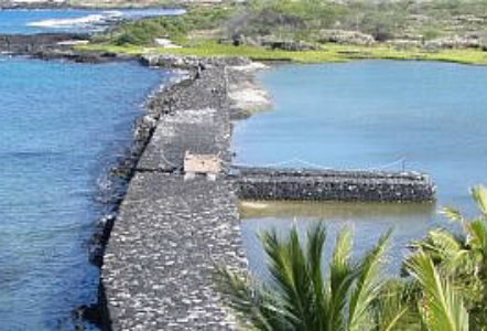
Courtesy of National Park Service
The 1160 acre park, a landscape of rugged lava rock, was at one time a thriving ancient Hawaiian settlement. More than 200 archeological sites document the Hawaiian people’s use of the area over time. These sites possess significant cultural, emotional, and historic values for the Hawaiian people. The Hawaiian people of this ancient settlement harvested fish from the sea and from fishponds they constructed. They grew coconuts, sweet potatoes, and gourds and raised chickens and pigs. Inhabitants of the area created a delicate balance between the sea, the land, and their extended families so that everyone thrived and lived in harmony. Those living closest to the shore harvested fish and other food from the sea, while ohana (extended family) living within the ahupua’a (sea to mountain land division) grew staple resources such as taro, breadfruit, paper mulberry, wood, and fiber for clothing. To ensure everyone’s survival, the ohana would trade these items with one another.
Archeological resources at Kaloko-Honokohau National Historical Park include kahua(ancient house site platforms), heiaus (religious sites), fishponds, a holua (toboggan slide), kii pohaku (petroglyphs), papamu (kokane game boards), stone enclosures,ahus (stone mounds that serve as altars, shrines, or security mounds), lava tube shelters, and parts of the Mamalohoa Trail (Kings trail). The two fishponds, Kaloko Fishpond and Aimakapa Fishpond, and the one fish trap, 'Ai'opio Fishtrap, reveal the ingenuity and detailed precision of ancient Hawaiian architecture, while the many scattered petroglyphs depict the tales of this ancient Hawaiian community.
Kaloko Fishpond, Aimakapa Fishpond, and the 'Ai'opio Fishtrap illustrate the ways in which native Hawaiians worked with their environment to manage and utilize the abundant resources of the sea. The two fishponds were originally inland bays. The Aimakapa Fishpond consisted of an area of water enclosed behind sand dunes, while a channel that the ancient Hawaiians dug between the pond and the ocean allowed water to circulate between the two sources. This circulation of water allowed the people to utilize this environment to obtain food and other resources. Studies suggest that ancient Hawaiians used the Aimakapa Fishpond for well over 600 years.
Ancient Hawaiians created the Kaloko Fishpond by constructing a dry stacked lava rock seawall that isolated the bay from the sea. To control the flow of water between the pond and the sea they used a makaha (sluice gates) and designed an angled seawall to diffuse the massive energy created by ocean waves. Once the seawall diffused and absorbed the energy, water was still able to circulate between the ocean and pond due to the porous nature of the lava rocks. The Kaloka Fishpond kuapa (seawall) was 30-40 feet wide and 6 ½ feet high stretching for 250 yards throughout its hundreds of years of use. Storms in the 1950s destroyed the wall, but the National Park Service is working to rebuild it. The National Park Service is relying heavily on archeological evidence, oral histories, one kupuna (elder), and the guidance of master masons skilled in traditional stonewall construction in order to rebuild the wall in such a way as to preserve and illustrate traditional Hawaiian culture.
Today, visitors can see the remnants of the stone and coral wall that formed the 1.7 acre 'Ai'opio Fishtrap. Native Hawaiians used the fishtrap to trap and catch fish during low tide. Fish would enter the fish trap through an opening in the trap or over the submerged walls of the trap during high tide. At low tide, the fish could not escape because their entrance points no longer existed. The fish were then stored in walled sections of the trap until needed, at which point, they were very easily caught.
Kaloko-Honokohau National Historical Park brings traditional Hawaiian culture alive. Walk along a self-guided foot trail to view Kaloko Fishpond, Aimakapa Fishpond, and the 'Ai'opio Fishtrap. Lounge on Honokohau Beach while viewing the ancient heiau that stands at the end of the beach. Hike along the Mamalahoa Trail, the Ala Kahakai National Historic Trail, or the Ala Hele Ike Trail taking in the many native plants, stone walls, and house platforms, just as the Hawaiians did many years ago.
Kaloko-Honokohau National Historical Park, a unit of the National Park System and a National Historic Landmark, is located on the west coast of Hawai'i Island, approximately 3 miles south of the Keahole International Airport and 3 miles north of the town of Kailua-Kona, on the ocean side of Highway 19. The visitor center, Hale Ho'okipa, is located half a mile north of the entrance to Honokohau Harbor. The Kaloko road gate is located across the highway from the Kaloko New Industrial Park (across from the big yellow "Kona Trade Center" building). The park is open from 8:00am to 5:00pm daily. For more information, visit the National Park Service Kaloko-Honokohau National Historical Park website or call 808-326-9057.
Last updated: August 15, 2019
