")
NPS Photo / Shaina Niehans
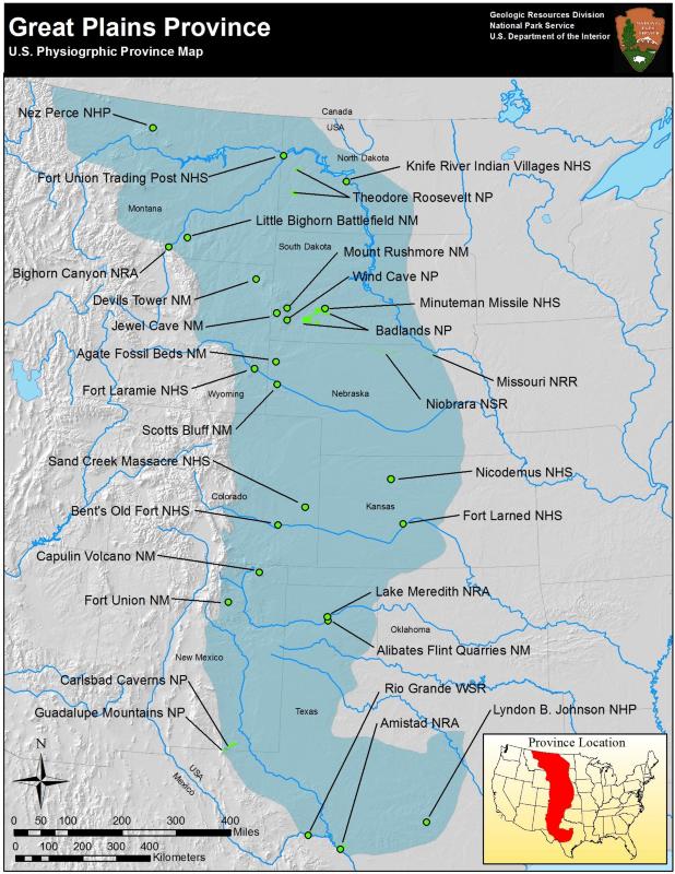
The Great Plains spans 725,000 square km (450,000 mi) of flat “high plains,” bordered to the west by the Rocky Mountains. The eastern border with the Central Lowlands is less distinct; the separation is characterized by the 50 cm (20 in) rainfall divide, as well as changes in vegetation and soils. The Great Plains slope downward to the east, with maximum heights in the foothills of the Rockies at 1,700 m (5,500 ft) decreasing to 610 m (2,000 ft). The bedrock is horizontal beds of sandstones, shales, limestones, conglomerates and lignite. The High Plains region in the center of the Great Plains is overlain by alluvial sediments from the Rocky Mountains by east flowing streams. In the northern Great Plains, glacial till overlies the Mesozoic bedrock. This area is also populated by small mountain groups caused by igneous activity and uplift. Most notable of these is the Black Hills, a region of forested slopes with deep valleys cut by streams rising strikingly from the surrounding semiarid plains. The presidential carving Mount Rushmore is in the Black Hills, in Precambrian crystalline rocks.
The Badlands of South Dakota exist where poorly consolidated clays and shales are unprotected by vegetation. Even though rainfall is sparse in this area, brief downpours can turn dry streambeds into torrents with dramatic erosional results. The soft rocks are carved into starkly picturesque pinnacles, ridges, and spires. The rapid erosion also exposes fossils of vertebrate animals that lived when the sediments were being deposited. A section of this terrain is a designated National Park.
Wind Cave National Park and Jewel Cave National Monument are noteworthy features in the Black Hills. Wind Cave acts as a ‘natural barometer,’ with wind blowing out of the cave when outside pressure is low, and into the cave when the outside pressure is high. Jewel Cave is beautifully decorated with stalagmites and stalactites, flowstones, and large calcite crystals.
Devils Tower is an igneous feature; a jointed column of rock rising 260 m (850 ft) vertically out of the surrounding flat plains. Devils Tower was designated by Theodore Roosevelt as the first National Monument in 1906.
The Nebraska Sand Hills are one of the largest expanses of sand dunes on North America covering 39,000 square km (24,000 mi). It is thought that the sand originated in stream beds that ran dry, allowing wind to carry the sand to neighboring uplands. Much of the sand is stabilized by vegetation and is used as grazing lands.
Coal, petroleum, and natural gas are all mined extensively throughout the Great Plains. Homestake mine in the Black Hills of South Dakota is one of the most important gold mines in the country, with excavation taking place up to 1.5 km (1 mi) beneath the surface. This gold occurs in metamorphosed Precambrian sediments.
Educational Resources
GeoKansas
- GeoKansas is a place to learn about Kansas geology! Learn about the general geology, fossils, rocks and minerals, and different places to visit for Kansas geology.
Secrets of the Past
- Watch a six minute ranger video on the geology of Badlands National Park and complete one of the suggested in classroom activities (grades K-8).
Great Plains Parks

NPS photo/Ronal C. Kerbo
Part of a series of articles titled Physiographic Provinces.
Previous: Columbia Plateau Province
Last updated: April 30, 2018