Last updated: December 27, 2017
Article
C&O Trees in Uplands and Lowlands
Flooding effects lots of things – but not always what you might expect.
As it turns out, some trees just can't tolerate having wet feet!
Which species dominate the dry uplands and the flood-prone lowlands?
Here's how to let the trees tell you where you are.
As it turns out, some trees just can't tolerate having wet feet!
Which species dominate the dry uplands and the flood-prone lowlands?
Here's how to let the trees tell you where you are.

NPS/Coriell
To protect the C&O Canal’s natural resources, National Park Service staff from the Inventory and Monitoring (I&M) division monitor forest vegetation in seventy-five plots along the C&O Canal, tracking the composition and condition of trees, shrubs, and vines. During monitoring, staff record data including the total number of trees at each plot, the species identity, and diameter at breast height (DBH) for every tree. This brief summarizes tree data for C&O Canal using a common forestry metric called the Importance Value (IV) and shows which species dominate in lowland forests versus upland forests.
Tree Importance Value
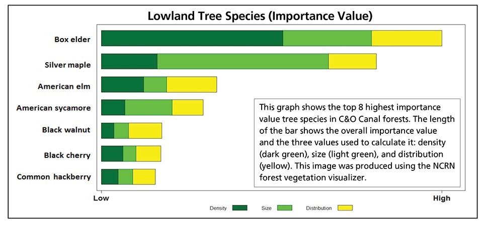
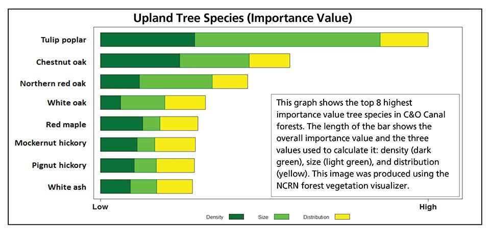
We used Importance Value to compare tree species present in upland and lowland sites on the C&O Canal.Tree Important Value (IV) is a metric for comparing the dominance of tree species found in a given area. IV is based on three factors—density (number of individuals), size of individuals (calculated from DBH), and distribution (how widespread they are).
Trees of Lowland Floodplains

The graph above shows that the most “important” tree in C&O Canal lowland forests is box elder (Acer negundo), mostly because there are a great number of trees of this species. Silver maple (Acer saccharinum) comes in as second, as silver maples tend to grow quite large, though they are fewer in number.
Trees of Uplands

Oaks (chestnut, northern red, and white; Quercus spp.) are the next three most dominant species of upland forests, with individuals growing to very large sizes. Red maple (Acer rubrum) and two species of hickory (Carya spp.) round out the list of upland tree species with the next highest importance values.
Learn More
To help protect natural resources ranging from bird populations to forest health to water quality, the National Park Service has a staff of scientists who do Inventory & Monitoring (I&M) work in parks across the country. The National Capital Region Network, Inventory & Monitoring program (NCRN I&M) serves national parks in the greater Washington, DC area. Visit our website to learn more about NCRN forest monitoring.This article is based on material originally published as a resource brief.
