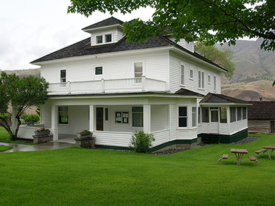
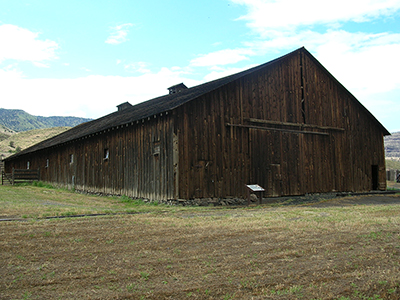
The Cant Ranch Historic District, located in the Sheep Rock Unit of John Day Fossil Beds National Monument, is a 200-acre vernacular landscape that documents early 20th century ranching operations in the John Day River Valley. The period of significance begins in 1910 with the purchase of the land by James Cant and ends in 1975 when the Cant Ranch was sold by the family to the NPS.
James Cant arrived in eastern Oregon in 1905 as part of a wave of Scottish migrants that settled in the John Day River valley during that era. Like Cant, many got their start by working for other already-established ranchers.

NPS

NPS
The ranch is located along the John Day River, which flows through the Columbia Plateau physiographic region that covers most of eastern Oregon. Access to the ranch is along the John Day Highway (Highway 19) which passes through Butler Basin.
The basin is defined on the south by Picture Gorge, a steep and narrow basalt canyon cut by the John Day River, and the geologic formation called Goose Rock to the north. Within the basin, the river has carved a flat valley that extends approximately three and one-half miles and that varies in width from about four hundred to eighteen-hundred feet. Agricultural fields, actively used since the turn of the century, stretch along both sides of the John Day River for the entire length of the valley. The Cant Ranch complex is situated on the west side of the river, about two miles north of Picture Gorge. Sheep Rock, a prominent natural feature in the corridor, rises to an elevation of 3360 feet to the southeast of the ranch complex.
Prior to Euro-American settlement of the John Day Valley in the 1800s, the area between the Southern Columbia Plateau and the Northern Great Basin was occupied and used by several American Indian peoples. This includes the Tenino and Umatilla, who were historically part of the Columbia Plateau peoples, and the peoples of the northern Great Basin, the Northern Paiute.

NPS
The ranch is locally significant as an intact example of a successful, early 1900s ranch within the John Day area. There are three historic periods represented in the landscape of the Cant Ranch Historic District: the Officer Homestead era (1890-1909), Cant Sheep Ranch era (1910-1946), and the Cant Cattle Ranch era (1946-1975).
While both the ranch complex and the agricultural fields contain landscape resources from all three historic periods, the majority of structures and features relate to the sheep ranch era. The period of significance established in the Cant Ranch Historic District National Register nomination is 1910-1975.
Along with their success in ranching, the Cants became prominent members of the valley community and played an important role in the area’s development. Travelers through the valley were welcomed and given a meal and, when needed, a bed. Family members recall that the need to accommodate the frequent travelers and houseguests was one of the reasons Cant built such a large house. The house and grounds of the ranch were the scene of many social gatherings for the Scottish community, and the upper basin area's first school was started at the Cant Ranch in 1919.
The character of the historic district is evident in the following landscape characteristics: spatial organization, natural systems and features, circulation, and buildings and structures. The major Cant Ranch contributing features that have been preserved and maintained by the park include the main house, sheep barn, sheep shearing pens, Watchman's Hut, other outbuildings, two orchards, a residential lawn, ornamental vegetation, vehicle and pedestrian circulation systems, cable car crossings, irrigation ditches, fences and gates, and four agricultural fields.The NPS restored the sheep shearing pens in 2006, and they are some of the best examples of local sheep shearing pens from the period of significance. Collectively, the remaining features aid in interpreting the agricultural heritage of the historic district and showing how it has evolved over time.
Quick Facts
- Cultural Landscape Type: Vernacular
- National Register Significance Level: Local
- National Register Significance Criteria: A
- Period of Significance: 1910-1975
Landscape Links
Last updated: January 6, 2020
