Last updated: March 2, 2020
Article
2019 Weather In Review: Bluestone National Scenic River

In order to better understand ecosystem health in national parks, the Eastern Rivers and Mountains Network measures ecosystem "vital signs" in select national parks in West Virginia, Pennsylvania, New Jersey, and New York. One of those vital signs is weather and climate. Below is a summary of 2019 weather conditions at Bluestone National Scenic River.
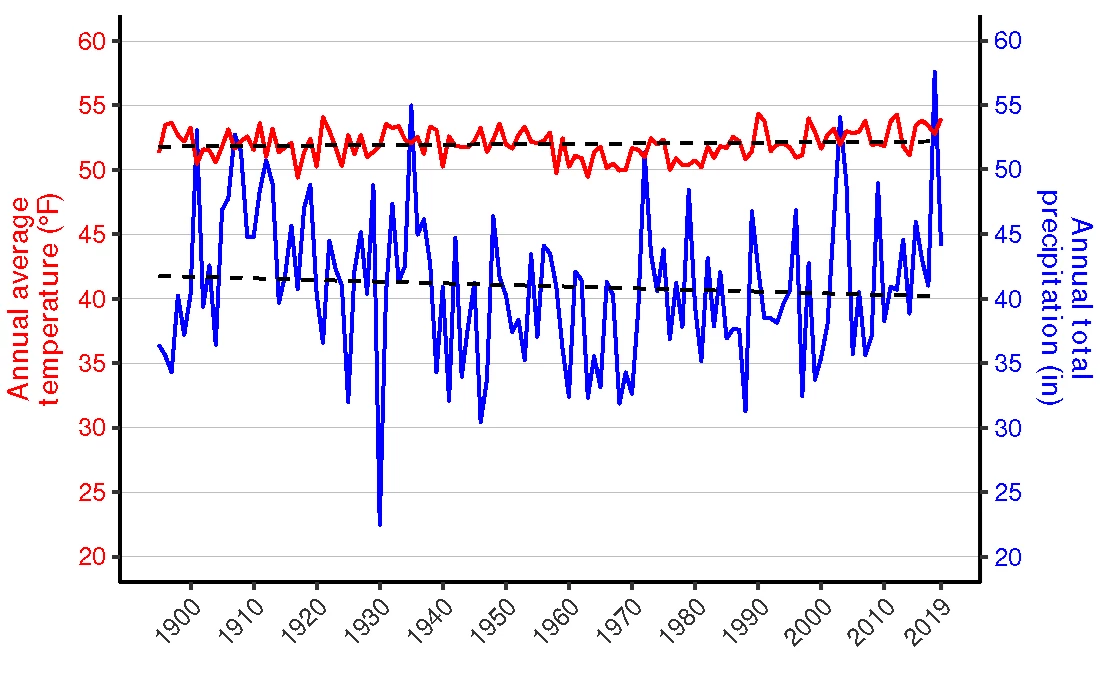
In all, 2019 was very warm and wet with temperatures and precipitation both well above normal. The year ended as the 6th warmest and 35th wettest since 1895. Weather data collected from surrounding areas from 1895–2019 show an increasing trend in annual average temperature (+0.03 °F per decade) and a declining trend in annual total precipitation (-0.13 inches per decade).
Information in this brief represents county-scale weather data averaged from all of the counties surrounding the park. These counties include Mercer and Summers counties, West Virginia. Individual weather station data may vary from what is reported here. Data are available from the National Climate Data Center.
Temperature
In total, 2019 was the 6th warmest year at the park since 1895. In particular, summer and spring were much warmer than normal (Figure 1). Nine months had higher than average temperatures, with February, May, September, and December all being more than 4 °F above normal (Table 1).

| Month/Year | Average temperature (°F) | Departure from long-term average (°F) |
|---|---|---|
| January | 32.4 | +0.5 |
| February | 40.5 | +6.6 |
| March | 40.4 | -1.8 |
| April | 54.6 | +3.0 |
| May | 65.2 | +4.6 |
| June | 66.1 | -1.7 |
| July | 72.7 | +1.5 |
| August | 70.2 | +0.2 |
| September | 69.8 | +5.5 |
| October | 57.4 | +3.8 |
| November | 39.4 | -3.4 |
| December | 39.2 | +5.0 |
| 2019 | 54.0 | +2.0 |
Table 1. Monthly and annual average temperature and departure from long-term averages. Departures from average show how different 2019 was compared to relevant averages from 1895-2018.
Precipitation
In total, 2019 was wetter than normal with a total of 44.2 inches of precipitation — 3.3 inches more than the long-term average (Table 2). In contrast to other seasons, the summer was extremely dry (Figure 2). When compared to the historical record, it was the 35th wettest year since 1895 (Figure 2).

| Month/Year | Total precipitation (in.) | Departure from long-term average (in.) |
|---|---|---|
| January | 3.2 | 0.0 |
| February | 7.0 | +4.0 |
| March | 2.4 | -1.4 |
| April | 4.1 | +0.7 |
| May | 5.2 | +1.3 |
| June | 4.1 | +0.2 |
| July | 4.0 | -0.4 |
| August | 2.7 | -1.1 |
| September | 0.4 | +2.6 |
| October | 5.4 | +2.7 |
| November | 2.3 | -0.4 |
| December | 3.4 | +0.3 |
| 2019 | 44.2 | +3.3 |
Temperature and Precipitation Trends
(1895-2019)
Data from 1895–2019 for Mercer and Summers counties, West Virginia show an increasing trend in annual average temperature (+0.03 °F per decade) and a declining trend in annual total precipitation (-0.13 inches per decade).

Climate Change
Today's rapid climate change challenges national parks in ways we've never seen before. Wildlife migrations are altered, increasingly destructive storms threaten cultural resources and park facilities, habitat is disrupted—the list goes on. Click here to discover how climate change is affecting our nation's treasures, what the National Park Service is doing about it, and how you can help.For more information, contact Mid-Atlantic Network Biologist, Jeb Wofford or Eastern Rivers and Mountains Network Program Manager, Matt Marshall.
