Article

Cumberland Island National Seashore Cultural Landscapes
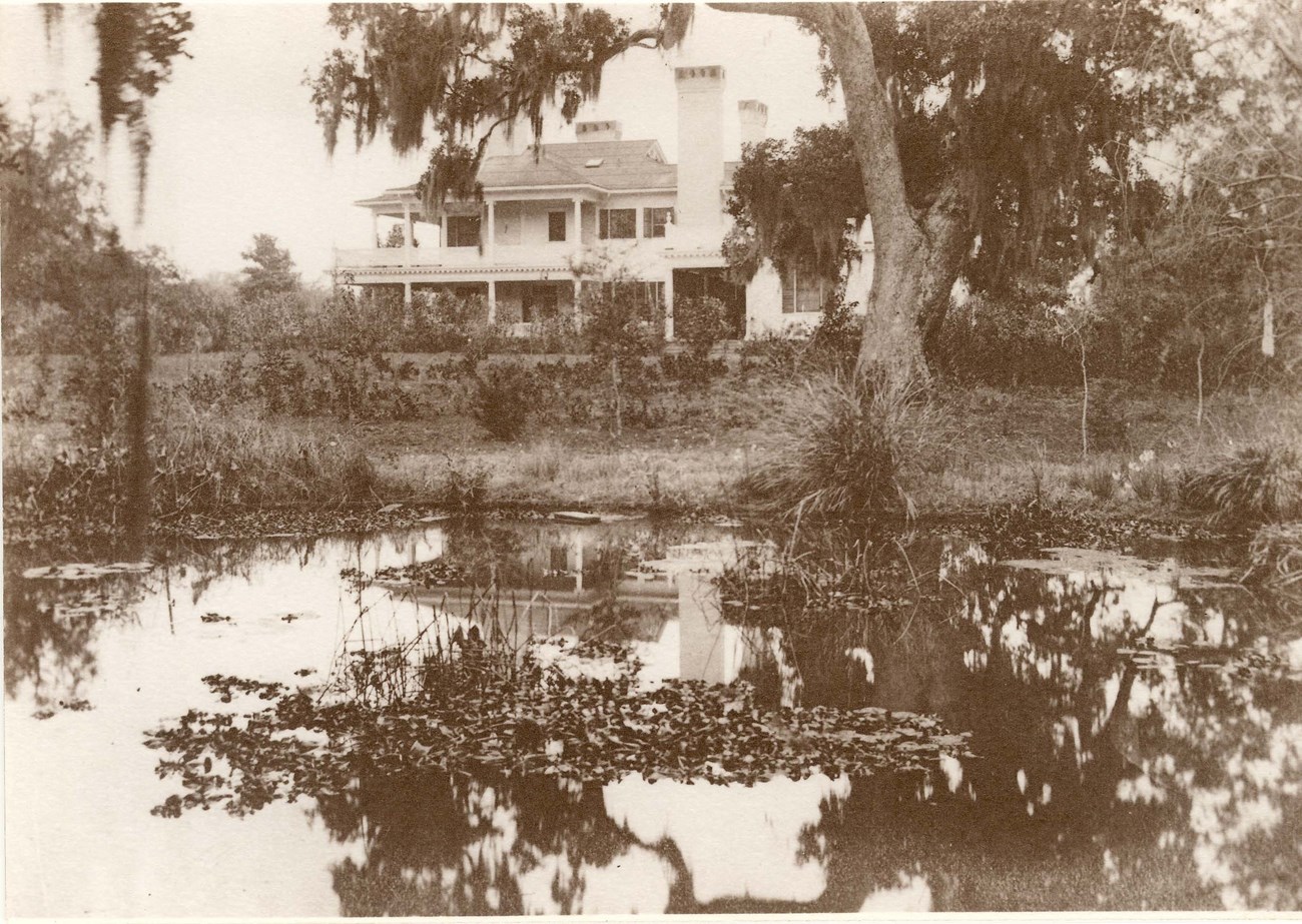
Water plants grow in a pond, with trees, shrubs, and a two-story house with chimneys beyond.
The Cottage at Dungeness Estate, seen from the Duck Pond, was built c. 1900 for Thomas Morrison Carnegie II.

NPS Photo / Cumberland Island National Seashore Archives 4561

Imagine stepping back in time to the early 1900s, on a secluded private island dotted with summer “cottages” of the one of the wealthiest American families - the Carnegies. Imagine having 17 miles of pristine beach to yourself, and then taking a stroll through the dense maritime forest. This is what it is like to visit Cumberland Island National Seashore today.
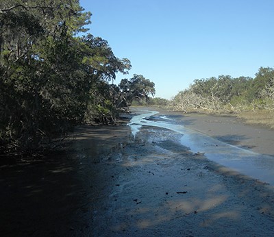
A thin, shallow creek weaves through a muddy tidal area, between tree-lined shores.
The tidal creeks located throughout the island are home to alligators, raccoons, crabs, horses, and birds.

Photo courtesy of K. Mork

The island has a rich history, with layers of cultures and events that are etched on the landscape. For over 4,000 years, humans have utilized the island for settlement and supplies. The earliest ceramic shards date back to around 2,000 BCE. A Timucuan tribe was the first to inhabit the island. In 1587, Spanish priests and soldiers established San Pedro De Macamo and San Pedro y San Pablo de Porturiba on San Pedro (the Spanish name for Cumberland). The goal for the missions was to convert the native population to Christianity and form an alliance against the British. The missions were in service until 1686.
When South Carolina was colonized in 1670, conflicts amongst the Spanish and the British increased. James Oglethorpe, founder of Savannah, commissioned the construction of two forts on Cumberland Island in 1736. Fort St. Andrews was located at the northwest end of the island and Fort Prince William was at the southern end. King George’s War in 1740 forced James Oglethorpe to hand over Cumberland Island, along with the forts, to the Spanish.
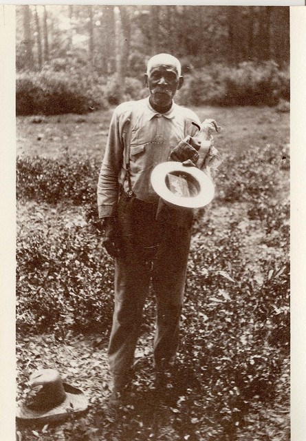
Historic image: A bald man with mustache and suspenders stands amid low plants, holding a brimmed hat.
Primus Mitchell in 1917, former slave of Robert Stafford.

NPS Photo / Cumberland Island National Seashore Archives 4577

The island remained a no-man's-land from 1748 to 1763, when the Spanish ceded Florida to the British. At this time, a planter from South Carolina purchased 7,500 acres to market and sell as quality land for plantations. The plantations produced cash crops for export, including citrus fruit and olives. However, the most successful exports were Sea Island cotton and timber.

By the 1840s, most of the island was cleared for production. The plantations were prosperous until the Civil War. During the Civil War, plantation owners abandoned their lands and slaves. The Union occupied the island and the waters around it from 1862 until the end of the war. Most of the African American population fled to nearby islands. Those that chose to stay created the Settlement on the north end. Following the war and short-lived efforts to redistribute confiscated land to freed slaves, many of the landholdings on Cumberland Island reverted to their pre-war owners.
Small rectangular building with double doors at one end and white siding, with one-story dwelling surrounded by vegetation in background
The First African Baptist Church and a dwelling in the Settlement at the North End. Formerly enslaved African Americans built this community after the plantation period. The occupants worked at the hotel. This area was 5 acres, with lots set to 50 by 100 feet. The homes were constructed out of left over material from old houses.

NPS Photo

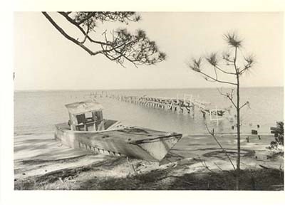
The ruins of a wooden steamboat rest on a sandy beach, with a wooden wharf extending into the water.
Cumberland Wharf ruins on the north side of the island, c. 1965.

NPS Photo / Cumberland Island National Seashore

In the 1870s, the island served as a type of resort to tourists traveling to Florida by way of train. A steamboat route brought visitors to the island, where they stayed at two hotels located at the north end. The Orient Hotel was located on the river, and the High Point Hotel was later built on the ocean side. Wealthy industrialist families were also drawn to the Sea Islands for winter homes.

In 1881, the Carnegies -- of the well-known Pittsburgh steel manufacturing family -- arrived on the island, purchasing the plantation at Dungeness on the south end. The Carnegies eventually owned 90 percent of the island. They built homes and established their own reserve. With the death of the last direct Carnegie child, the next generation of descendants decided to give the land to the federal government in order to preserve the beauty of the island. The Cumberland Island National Seashore was established as a unit of the National Park Service in 1972.

The Cumberland Island Setting


Cumberland Island National Seashore is located in Camden County, Georgia, roughly 4.25 miles due east of St. Marys, Georgia. Cumberland Island, part of the Sea Islands, is the largest and southernmost barrier island in Georgia and is not connected to the mainland by causeway or bridge. It is bordered to the west by the intercostal waterway, the south by St. Marys River and the Florida/Georgia state line, the Atlantic Ocean to the east, and Little Cumberland Island to the north. The island is only accessible by private boat, ferry, and private plane. The flat, low topography of the barrier island setting gives way to wide ocean beach and sand dunes to the east and marsh to the south and west.
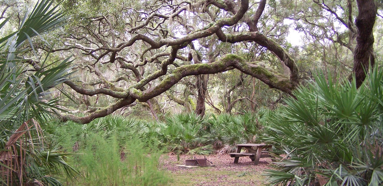
Picnic table surrounded by the curving branches of a live oak and other vegetation around
The live oaks were harvested for lumber and have been used to build boats. The majority of the live oaks date to the Civil War, after the end of the plantation period. They create a canopy that allows for peaceful experience when walking along the trails on the island.

Photo courtesy of K. Mork


Dungeness Historic District Landscape

The appearance of the Dungeness Mansion, part of the Dungeness Historic District, is the result of successive periods of human habitation and development. The landscape carries the imprint of American Indian settlement, then plantation agriculture, with a final dominant overlay of the Carnegie-era.

The widow of American Revolution Major General Nathanael Green, Catherine, and her new husband, Phineas Miller, built the original house at Dungeness in 1803. The era was marked by the working plantation with a formal landscape near the main house, with garden beds and symmetrical walkways. Cultivated fields of cotton and orchards of olives, oranges, and figs textured the extended landscape, grown and harvested using enslaved labor. During the Civil War, the plantation was abandoned and the house and gardens fell into ruin.

The Carnegie family purchased the estate in 1881 and constructed the Dungeness Mansion in 1884 on the site of the plantation era house, transforming the previously agricultural site into a private estate of gardens, lawns, outbuildings, and a service area. The family employed over 200 people to run their estate and their other homes on the island.
Historic image: Driveway to a large estate home is framed by landscaping, including pruned shrubs in planters.
The approach to Dungeness Mansion, date unknown.

NPS Photo / Cumberland Island National Seashore Archives 4648

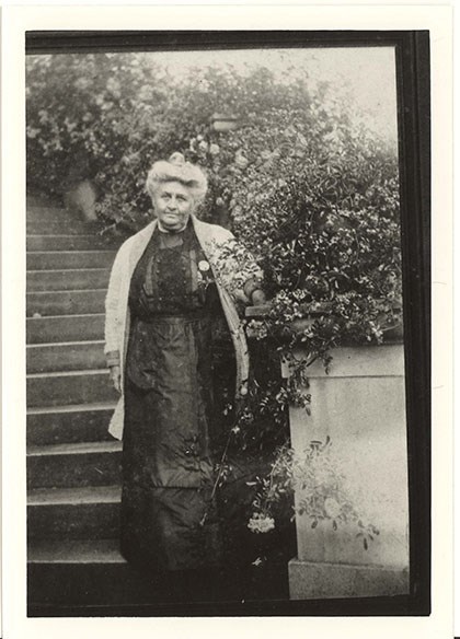
A woman stands at the base of a staircase beside flowering vines, wearing a long dress and her hair in a loose bun.
Lucy Coleman Carnegie (1847-1916), date unknown

NPS Photo / Cumberland Island National Seashore Archives 5299

In 1896, Lucy Carnegie hired the prominent Boston architectural firm Peabody and Stearns to expand the Dungeness Mansion, and between that time and 1916 the grounds were redesigned to include a fountain garden, water wheel, sundial, pergola, and rose garden. The estate and landscape became a showpiece for entertaining wealthy friends, offering proximity to the natural beauty of the island and a place of luxurious repose.

Although many of the prominent structures and landscape patterns date to the Carnegie era, artifacts below the surface - ruins of slave villages, patterns of field and forest, gardens and structures - represent the layering of landscapes that tell the story of development here. The landscape is primarily a landscape ruin whose historic significance is derived from these two periods, the Greene-Miller-Shaw-Nightengale plantation era and the Carnegie estate era. The district conveys the agricultural history of the Georgia Sea Islands and the Gilded Age development of grand estates. Efforts to restore or preserve the historic landscape are focused on the year 1916.

Quick Facts

  • Cultural Landscape Type: Designed
  • National Register Significance Level: State
  • National Register Significance Criteria: A, B, C, D
  • Period of Significance: 1803-1916
  • NRIS Number (National Register): 84000920
Dungeness

Historic District Cultural Landscape Report

More landscape history and features
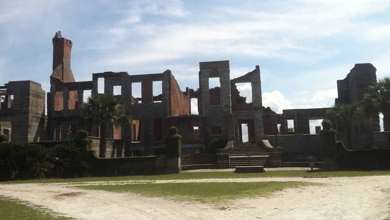
Vines cover sections of a two-story building ruin with a brick chimney and rectangular holes that were once windows.
Dungeness Ruins. The Mansion that once was the heart of the estate was vacant soon after 1925 and fell into ruins after a 1959 fire.

Photo courtesy of K. Mork


Plum Orchard Historic District
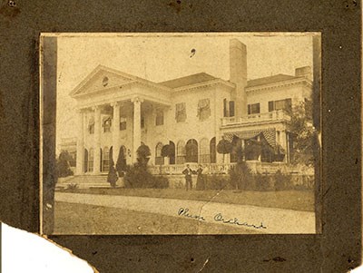
Three people stand on the lawn in front of a grand two-story house with four columns at the front and striped bunting over the windows.
Plum Orchard Mansion, c. 1900

NPS Photo / Cumberland Island National Seashore Archives 4331

The Plum Orchard Historic District landscape was a nineteenth-century plantation that was transformed in 1898 into a grand Carnegie family estate, typical of those developed by wealthy industrialists on the Sea Islands at that time. The Carnegies developed the agricultural landscape of cotton fields into a picturesque pleasure ground, inviting their well-off visitors to experience the beauty of a barrier island.

The Plum Orchard Mansion was a centerpiece of the historic landscape. The Classical Revival style structure overlooking the Brickhill River was built in 1898 for Lucy Carnegie's son, George Lauder Carnegie.
Historic image: Aerial view of estate includes the house, entrance drive, gardens bordered by uniform hedges, and trees beyond.
Plum Orchard in 1910

NPS Photo / Cumberland Island National Seashore Archives

During the period of significance (1898-1917), the landscape surrounding the mansion included a winding entrance drive, lawn interspersed with native trees, a reflective water feature, vegetable and flower gardens, and other support structures laid out along a circular road. The landscape style exemplifies the Country Place era of landscape design with the tree-lined entrance road linking the mansion, carriage house, and service area and a naturalistic, park-like style surrounding the house with terraces, orchards, cutting and ornamental gardens, bridges, greenhouses, and stables.
While most features in the present landscape reflect the period of the Carnegie family estate, the Plum Orchard cultural landscapes may also hold tangible remnants of the plantation era. A grave site and the ruins of the Deptford Tabby House may be associated with the owner of the plantation between 1823 and 1853, Peter Bernardey, and may yield information about the family and their lifestyle.

Quick Facts

  • Cultural Landscape Type: Designed
  • National Register Significance Level: State
  • National Register Significance Criteria: A, B, C, D
  • Period of Significance: 1898-1917
  • NRIS Number (National Register): 84000258

Plum Orchard

Cultural Landscape Inventory report

More landscape history and features
A two-story mansion has four columns across the front, a curving entrance road, chimneys, and rows of windows.
Entrance to the Plum Orchard Mansion

Photo courtesy of K. Mork


Other Cultural Landscapes at Cumberland Island National Seashore

  • Rayfield Archeological District
  • Half Moon Bluff / High Point
  • Stafford

Landscape Links


Cumberland Island National Seashore

Last updated: May 21, 2019