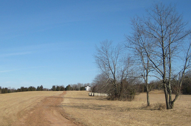
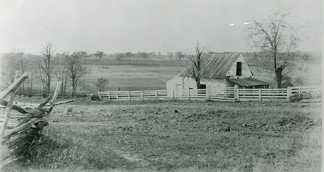
The Brawner Farmstead landscape is located in the northwest corner of Manassas National Battlefield Park in Virginia. On August 28, 1862, fighting broke out here between "Stonewall" Jackson's wing of the Confederate Army of Northern Virginia and a division of the Third Corps of the Union Army of Virginia. In addition to its association with the Second Battle of Manassas, the landscape is historically significant for the agricultural development of the area.
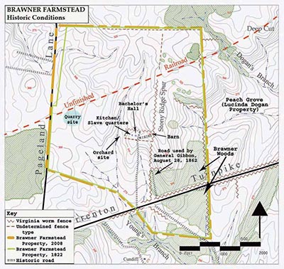
[Union General Gibbon] led the 2nd Wisconsin...through Brawner Woods, along a farm road...suddenly, from woods a quarter mile ahead, they found themselves confronted by two divisions of Confederate infantry, marching toward them in battle formation. Earley and Fanning, in Brawner Farm Cultural Landscape Report, NPS, 2005

NPS
The Brawner Farmstead site encompasses about 344 acres of Manassas National Battlefield Park, roughly thirty miles west of Washington, DC. The north and east boundaries of the farm trace the same property lines as the historic Douglas/Brawner tract.
The Brawner Farmstead was originally purchased as two separate tracts of land by Revolutionary War veteran George Tennille. The northern portion measured 180 acres, and the southern portion was 208 acres. In the first half of the 19th century, work began on the Warrentown Turnpike, linking the western part of Prince William County to the active Potomac River port. Also during that time, agriculture in Virginia began to pick up after a period of decline, encouraged by product diversification and new techniques like crop rotation and fertilizer use.
Following his death, George's wife Sarah later leased the property to John Brawner during the Civil War. The Davis family purchased the farm in 1895 and owned it for most of the 20th century until it was acquired by the NPS in 1985.
The small section of the farmstead that is located to the south of Rt. 29 measures 29 acres, and it also once formed a part of the Douglas/Brawner farm. It was owned by the Davis family and later by Hazel/Peterson Companies et al., who planned to develop the land into a mixed-use development. In 1988 the NPS acquired this tract, which was known as the Stuart’s Hill Tract and was the site of Robert E. Lee's headquarters during the Second Battle of Manassas.

NPS (Manassas National Battlefield Park archives)
The Brawner Farmstead property played a significant role in the Second Battle of Manassas. The antebellum farmhouse known as Bachelor’s Hall, built by George Tennille, anchored the right of the Confederate line on the evening of August 28, 1862, and the conflict continued to rage on the property over the next two days. Portions of the current house, completed by 1905, may incorporate pieces of the masonry and brick from the original farmhouse. This house is the primary building on the property today, and it stands partially in the same location once occupied by the historic home that existed during the Civil War.
The historic significance of the Brawner Farmstead is associated with the Civil War (1861 to 1865) and the period of agricultural development of the area (from 1800 to 1905). In addition, the landscape is notable for its association with the Confederate General Thomas J. “Stonewall” Jackson. It may also have capacity to yield further archeological information about the battle and the character of the Douglas/Brawner Farmstead.

NPS (Brawner Farmstead Cultural Landscape Report, 2005)
Today, the Brawner Farmstead retains a high level of integrity to these historic periods. The landscape consists partly of cleared farmland and is actively cultivated. Although it wasn't an especially prosperous farm, this property has continually been devoted to agricultural practices, which have helped to preserve the historic landscape of the battlefield.
Views and vistas were also important to the landscape history. From Stony Ridge, also known as Douglas Heights, Confederate forces under command of Stonewall Jackson could see Warrenton Turnpike, enabling them to open fire on Union troops. Recent landscape rehabilitation efforts by the NPS are aimed at maintaining views of the Brawner Farmstead to appear as they did during the Civil War.
A large swath of land in the northeast corner of the property was cleared to restore a historic open vista toward the east. Lands belonging to the old William H. or Lucinda Dogan Farm (Peach Grove) can now be seen across the rolling fields, while a portion of the Deep Cut battlefield can be had through the trees, providing visitors with one of the most pivotal vistas of the Second Battle of Manassas.
In the southeast corner of the property, the size of Brawner Woods is near double what it was during the 1860s, as 20th century forest growth has extended north of the historic wooded area. These non-historic woodlands impact interpretation of the battles, as the lines of sight that dictated troop movements and patterns are obstructed by woodland.
Quick Facts
- Cultural Landscape Type: Vernacular
- National Register Significance Level: National
- National Register Significance Criteria: A, B, D
- Period of Significance: 1800-1905, 1861-1865
Landscape Links
Last updated: October 8, 2021
