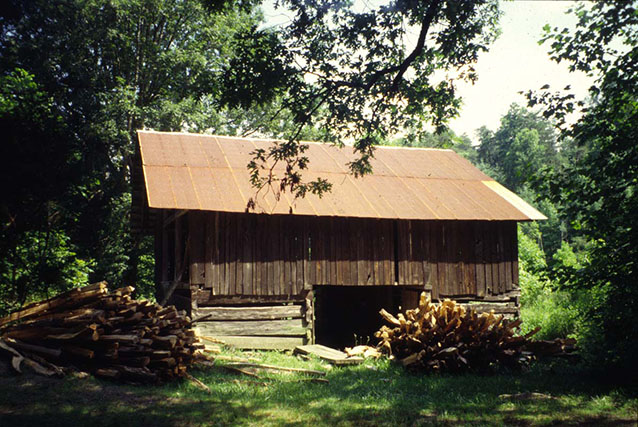
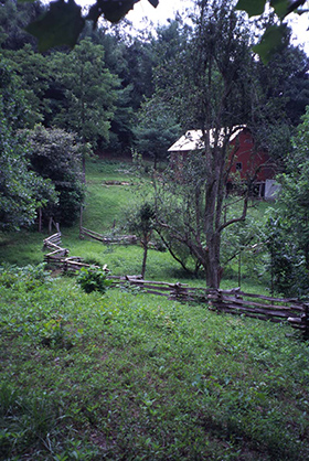
The Charles Rudy Slaven/John Litton Homestead is a 184-acre landscape located on the North Fork of the Fall Branch in Scott County, Tennessee. The farmstead was typical of those found in the region during the late 19th and early 20th centuries, though it is the only site known to have a human-made dam and pond. This transitional Cumberland Farmstead takes on characteristics of both a gorge farm and a plateau farm.

NPS
The Farmstead contains many features typical of a Cumberland Farmstead in the Big South Fork region and is representative of settlement patterns in the region. The cultural landscape's historic significance begins around 1900, with the construction of the log house, log barn, and outbuilding. This period continues until 1974, when the Big South Fork National River and Recreation Area was established.
Around the year 1900, John Litton, a local farmer, built a log house, log barn and log outbuilding on property located along the North Fork of the Fall Branch, a tributary of the Big South Fork River. John and Polly Litton lived at the site with their five children.
With its location along the upper reaches of the gorge, this Cumberland Farmstead takes on characteristics of both a gorge farm and a plateau farm. Like a gorge farm, water is readily accessible from springs and streams. In addition, the adjacent cultivated land is confined to level land near the stream, making it difficult for mechanized farming. The upper fields associated with this farmstead, on the plateau, supplemented the family income. Like other plateau farms, the site is easily accessible by road.

NPS
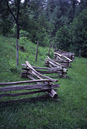
The Charles Rudy Slaven/John Litton Farmstead is typical of the settlement patterns found throughout the region in the late 19th and early 20th centuries. A number of historical landscape features still exist at the site, including fields, trees, pawpaw shrubs, road traces, fence lines, a human-built dam and pond, hog pen, still, and a building ruin. Buildings at the site include a circa-1900 log barn, a circa-1900 log and wood frame house, and a wood frame garage.
The Charles Rudy Slaven/John Litton Farmstead is part of the proposed Big South Fork Rural Historic District. This Historic District is significant at the state level for its association with the early settlement, agriculture and rural community life, and economy of the Upper Cumberland region in Tennessee. It is also an important example of the vernacular folk architecture once typical of the region. The landscape also has potential to yield further information important to understanding the historic human occupation of the area.
The diverse resources of the district are united historically and physically by their association with farming activity and rural life in the Upper Cumberland from 1821 to 1950. The district’s discontiguous pattern of historic rural landscapes separated by portions of undeveloped land vividly illustrates the intimate relationship that existed between the family farmers of the Upper Cumberland and the rugged terrain on which they lived.
The district is significant in the areas of agriculture, architecture, archaeology, community planning and development, exploration and settlement, and industry. Adaptive reuse, stabilization, reconstruction, and repair efforts over the years have altered some of the buildings and structures, but they nonetheless retain the bulk of their original materials and exhibit the historic vernacular designs of their local builders and inhabitants.

NPS
Unlike other agricultural communities in the state, the Big South Fork Basin communities of Station Camp and No Business maintained much of their subsistence orientation and informal communal organization well into the mid-20th century. Due mostly to the Basin’s naturally confining physiography, a historic lack of any developed road system, and the existence of only narrow parcels of arable floodplain, the rural landscapes that developed here and elsewhere in the Upper Cumberland were unique in how they displayed the intimate relationship between land and people.
For the settlers and farmers of the district, the relative lack of fertile soil meant that agriculture was only one of many activities that helped to sustain their families and related kin. Other pursuits included hunting, fishing, lumbering, mining, ranching, bee keeping, moonshining and a host of folk practices and economies that have only recently disappeared from the area.
Quick Facts
- Cultural Landscape Type: Vernacular
- National Register Significance Level: State
- National Register Significance Criteria: A,C,D
- Period of Significance: ca. 1900-1974
Landscape Links
Last updated: December 31, 2020
