Part of a series of articles titled Intermountain Park Science 2021.
Article
Yellowstone National Park & United States Naval Academy Partnership: Student Designs for Improved Shoreline Access at Lake Yellowstone Hotel
- Henry Crawford, Guest Scientist, Geologic Resources Division, National Park Service
- Rebecca Beavers, Coastal Geologist, Geologic Resources Division and Climate Change Response Program, National Park Service
- Jefferson Hungerford, Park Geologist, Yellowstone National Park, National Park Service
- David Kriebel, Professor of Ocean Engineering, United States Naval Academy
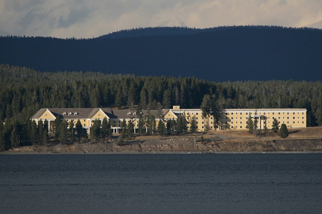
NPS photo/Jim Peaco.
Introduction
The National Park Service (NPS) and US Naval Academy (USNA) have collaborated on multiple ocean engineering projects through a partnership initiated in 2014. The NPS has identified capstone projects in National Park units for undergraduate midshipmen to meet requirements of their Ocean Engineering Capstone Design course (USNA 2019). Over the past five years, Professor David Kriebel, USNA Ocean Engineering Program, and Dr. Rebecca Beavers, NPS Coastal Geologist, have found a variety of senior-level field projects from across the nation for these students. For the initial projects, Dr. Linda York (Coastal Geologist, South Atlantic Gulf-Interior Regions 1, 2, and 4) was able to identify and help facilitate project selection at Fort Raleigh National Historic Site (North Carolina in 2014), Cumberland Island National Seashore (Georgia in 2015), and Fort Sumter and Fort Moultrie National Historical Park (South Carolina in 2017). Additional projects have resulted from Technical Assistance Requests submitted to the NPS Geologic Resources Division for coastal geology and engineering assistance including a 2013 request to address shoreline erosion along Yellowstone Lake (NPS 2019). This article describes the NPS and USNA partnership and work by a group of Naval Academy students and faculty from Fall 2018-Spring 2019 to address shoreline access at Lake Yellowstone Hotel in Yellowstone National Park (Figure 1).
This unique partnership provides authentic project experience for the US Naval Academy students while granting direct benefits to parks addressing vulnerable stretches of shoreline. Participating parks receive a feasibility type report and documentation to advance conceptual project scoping and design. When available, the parks provide housing for 3-5 students and at least one instructor for the 2-3 days of time at the park while the USNA covers travel expenses. The field component of this work is completed in the fall and requires some time from park staff to orient the field crews, provide documentation of the site concerns and shoreline change, and support access via boat if needed. In the spring, reviews of the draft report by park and Coastal Geology program staff have resulted in stronger products by the students and more useable products for the park. The final deliverables include a report containing design solutions, an oral presentation, and a poster that is presented along with all Ocean Engineering projects for all partners in April each year at the USNA in Annapolis, Maryland.
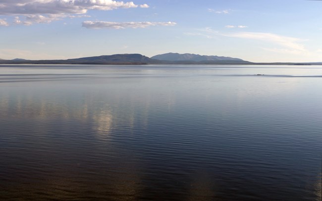
NPS photo/Diane Renkin.
Yellowstone Lake
Sitting 7733 ft (2357 m) above sea level exists a geologic wonder reminiscent of the beaches at Cape Cod National Seashore, Massachusetts and Golden Gate National Recreation Area, California. Yellowstone Lake of Yellowstone National Park in Wyoming is a hidden gem and the largest high elevation lake (above 7,000 feet) in North America (Figure 2). The 132 mi2 (341 km2) body of water is 427 ft (130 m) at its deepest point and was formed by a combination of glacial processes and rhyolitic lava flows that once filled the 631,000-year-old Yellowstone Caldera (Figure 3).
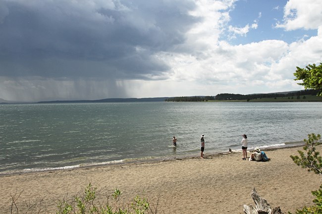
NPS photo/Jim Peaco.
Despite its mountainous geography, coastal processes along the lake’s 141 mi (227 km) of shoreline are analogous to those found within the 88 NPS ocean and coastal park units along the Atlantic and Pacific Oceans and Great Lakes. As a result, Yellowstone National Park shares many of the same management challenges often associated with coastal units. Similar to the effects of a changing sea level, the coastline of Yellowstone Lake fluctuates with lake level where higher lake level leads to bluff retreat and increased rates of erosion. In the winter, meter-thick ice can move unconsolidated sediment along the coast while spring rain transforms shoreline bluffs from above. Sustained high winds on the lake’s surface can drive the formation of large waves and cause wind set-up (a process by which winds push water from one area, where water level drops, to another area, where water level raises). As a result, the shores of Yellowstone Lake and its islands have been experiencing constant change since their formation.

Map adapted from NPS.
As one can expect, this dynamic landscape poses challenges at the nature-human interface. A 2013 visit to Lake Yellowstone by Dr. Rebecca Beavers revealed sites where coastal erosion threatened park infrastructure and impacted visitor experience (Beavers et al. 2014) -- an issue all too common among ocean and coastal parks. Active erosion of the bluff directly in front of the Lake Yellowstone Hotel undercuts the viewing platform and threatens the adjacent parking area and road (see location of hotel on lake, Figure 4).
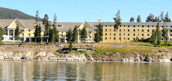
According to the National Park Service management policies, natural coastal processes such as erosion, deposition, and shoreline migration, will be allowed to continue without interference. However, modifications to coastal dynamics may be necessary when natural processes interfere with the preservation of historical resources and park infrastructure, (NPS Management Policies 2006). Park managers strive to achieve a balance between the preservation of park resources and the protection of natural systems in accordance with NPS Management Policies (Brunner & Simon 2016) (Figure 5).
Collaborative Process
After continued discussion among Dr. Jeff Hungerford, the Yellowstone National Park Geologist, and Dr. Rebecca Beavers it was decided that further analysis of the site was needed to mitigate impacts to park resources and provide safe visitor access. The mutualistic partnership between the National Park Service and the United States Naval Academy was about to be exercised again.
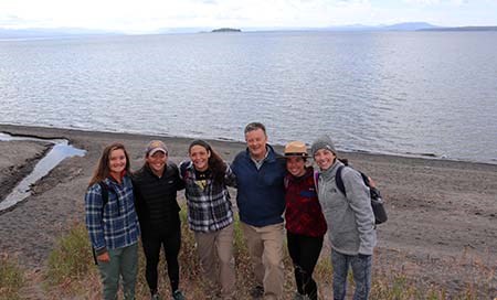
In February of 2018, the site was officially selected for the 2018-2019 USNA project. Professor David Kriebel organized a team of five midshipmen seeking to complete their Ocean Engineering Capstone Design project before dispersing into various Navy career paths. The students: Caroline Curtis, Christine Gaitantzis, Casey Lawson, Mary Morocco, and Marie Valenti, were tasked with addressing the shoreline erosion problem for the park by designing engineered solutions (Figure 6). As of July 2021, all five students are serving the country in the U.S. Navy or Marine Corps.
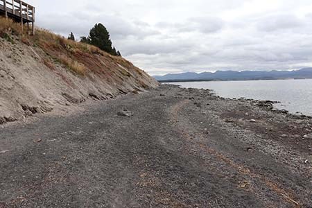
At the core, their designs needed to embody the National Park Service mission: The National Park Service preserves unimpaired the natural and cultural resources and values of the National Park System for the enjoyment, education, and inspiration of this and future generations, and the team faced the challenging balance between preservation of park resources and the protection of natural systems (NPS Management Policies 2006). During a site visit that took place from 12-14 September 2018, the USNA team focused its research efforts on the 1,200 ft (366 m) long bluff that borders the parking lot in front of the Lake Yellowstone Hotel (Figure 7). The team was hosted by Dr. Hungerford and by Dr. Erin White, Yellowstone National Park’s hydrologist, who helped students appreciate the unique geologic and hydrologic forces that formed Yellowstone Lake and the bluff at the site.
Site Methods and Analysis
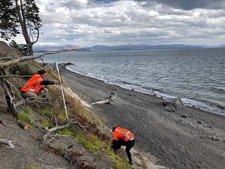
The midshipmen worked diligently in the field to maximize the amount of information gathered in the three-day visit, which was completed in the fall as part of their two-semester Ocean Engineering course. Their primary step was to scope the site (Figure 8).
At first glance, the bluff is clearly subjected to wave erosion along the bottom edge of the slope as noted by the holes in the glacial till where the till meets the sand and gravel beach (Figure 9). The top of the bluff is marked by narrow rivulets and has evidently experienced erosion by rainwater runoff, a process formally known as rill, or gully, erosion. The midshipmen noted that if the erosion at the top of the bluff was not treated, it will not only threaten the viewing platform and parking lot, but eventually cut further into the road and affect the flow of traffic around the Lodge. The team also noted safety concerns as Park visitors often scramble down the slope to reach the lake shoreline.
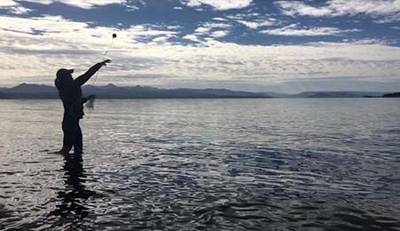
The capstone team proceeded to survey the area to gain a more detailed analysis of the site. The students plotted nine transect locations spanning across the 1,200 ft (366 m) section of bluff, spaced approximately 130 ft (40 m) apart. Each transect stretched from the top of the bluff next to the hotel down towards the shoreline with location and elevation data collected throughout. Next, a sonobuoy was attached to a line and thrown, by hand, an average of 50 ft offshore to collect bathymetric data of the nearshore profile (Figure 10).
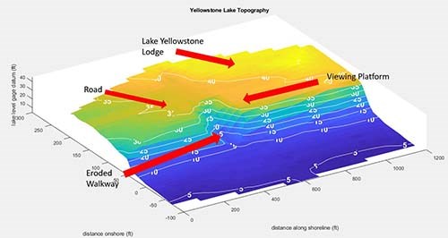
The team constructed a three-dimensional plot of the site using both the bathymetric and topographic data from which they took measurements critical to the final coastal engineering designs (Figure 11). In addition to the upper and lower bluff erosion, the students noted amplified erosion where visitors had created a social trail in order to access the shoreline in lieu of any formal access path. With this in mind, it was decided that the design solution would be separated into three different areas of concern: (1) drainage above the shoreline bluff to mitigate impacts by water runoff, (2) erosion protection below the shoreline bluff to protect against wave action, and (3) pedestrian access from the top of the bluff to the lakeshore below, including a walking platform along the bluff. The team recognized that their designs needed to align with particular needs expressed by the NPS and established the following constraints. The design solution should not negatively impact the surrounding environment nor detract from the natural beauty of the park. Furthermore, the maintenance needs, including the cost and labor required to preserve the overall effectiveness of the designs, should fall within the Park’s capabilities. Lastly, the design alternatives should facilitate safe transit from the top of the bluff to the shoreline.
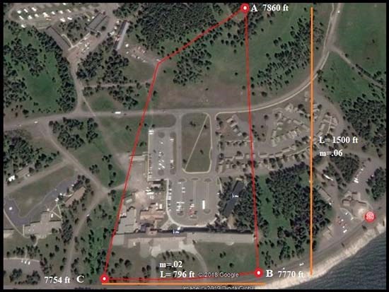
Once the full problem statement was understood and the desires of the National Park Service were confirmed, the capstone group returned to the USNA Campus in Maryland to begin the design phase in the spring of 2019. An environmental analysis was conducted to gain a better understanding of the conditions in which the final designs were to be constructed. For the lower bluff impacted by wave erosion this included identifying compatible sediment, fluctuations in local temperature and subsequent lake freeze-over, lake levels, wind speeds, wave heights, and the total extent of wave run-up against the shoreline bluff. Because rainfall and runoff play a large part in promoting erosion along the upper edge of the bluff, a rainfall analysis was completed to determine the volume of water moving through the region on a regular basis (Figure 12). [In Figure 12, the red line demarcates the local watershed. The orange lines were used to determine the slopes (m) of the project area. A, B, and C are elevations]. Evidently, these factors influenced which design characteristics were most suitable for the site and supported longevity of the structures. From the information gathered, the midshipmen designed a range of engineered solutions for each location of concern and selected preferred design solutions using a series of weighted-criteria decision matrices.
Results
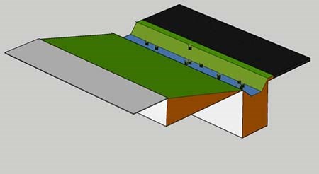
The capstone team’s final design utilizes naturally appearing features, provides enhancements to the surrounding area, and emphasizes public accessibility for the Park’s visitors. To address the upper bluff erosion by runoff, a swale-pipe and culvert design was chosen that impacts the surrounding area as little as possible and incorporates local vegetation which lines the bottom of the swale. The design captures and redirects surface water while maintaining a natural aesthetic (Figure 13).
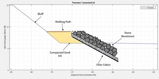
To address the lower bluff erosion, a stone revetment was used. The carefully designed pile of sloping boulders and sand provide a buffer to incoming wave energy at the bottom of the eroding bluff. The students recommended use of stone to match the natural boulders now found in places along the shoreline. Future enhancements could include interpretive signs along the walking path to inform visitors of the geologic history of the site. The structure also incorporates a compacted sand filled walkway on the top for visitors to walk on and discourages users from disturbing the bluff (Figure 14).
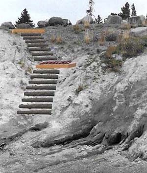
The third component of the design provides public accessibility to the lake shoreline, a new design feature for the site. A log stairwell design was created utilizing natural logs that integrate well with the Park’s environment. It provides sturdy and safe access from the parking lot on the upper part of the bluff down to the compacted walkway on top of the stone revetment (Figure 15).
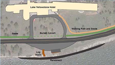
The team followed up by providing the park with a cost analysis of each preferred design and showed that an integrated design could accomplish multiple functions of safety, aesthetics, protection of Park infrastructure, and improved visitor experience (Figure 16).
Yellowstone National Park can use these designs to support initial project feasibility studies aimed at managing the erosion issue at Lake Yellowstone Hotel. The students have helped provide the park options to enhance visitor experience and safety while protecting park resources and maintaining the natural impression of the site. The designs will be considered among other mitigation techniques like moving the parking lot and road away from the eroding bluff. As with other shoreline projects, an official environmental analysis and National Environmental Protection Act (NEPA) process will occur. The students themselves have gained equal benefits through the collaboration. While engineering education too-often consists of exams, homework, and labs, this partnership provided a unique learning experience, with open-ended multi-faceted problems, on-site data collection, and interaction with Park Service professionals. The students’ newfound experiences will translate into valuable skills as they progress into various Navy career paths.
A Continued Partnership
“As for the project itself, I believe it provided the cadets exposure to real world design challenges and the tools used to create acceptable solutions. Opportunities like these are integral to the growth of our university undergraduates, and that’s why we should do our part to support them!” (Jeff Hungerford, Yellowstone Park Geologist). The unique partnership between the National Park Service and the United States Naval Academy has proven once again to be successful in assisting both park management needs and promoting student growth. With an increasing demand for coastal engineering expertise being felt at a servicewide level, the park service is grateful to have a sustained partnership with the USNA Department of Naval Architecture & Ocean Engineering. Additional projects at San Francisco Maritime National Historical Park (California) and Castillo de San Marcos National Monument (Florida) were completed in early 2020 (Ocean Engineering Capstone Design Project Series 2021). Further work is being discussed for future years.
For more information on this project and to discuss ideas for future ocean engineering student projects, contact Dr. Rebecca Beavers at 303-987-6945 and e-mail us.
References
Beavers, R. L., C. A. Schupp, I. A. Slayton, and M.Caffrey. 2014.
Shoreline erosion and adaptation strategies for Peale Island Cabin, Yellowstone National Park. Natural Resource Report. NPS/NRSS/GRD/NRR—2014/858. National Park Service. Fort Collins, Colorado DataStore - Published Report - (Code: 2216472) (nps.gov) Accessed July 15, 2021.
Brunner, J., and S. Simon 2016.
Policy. Pages 15 – 18 in R. Beavers, A. Babson, and C. Schupp, editors. Coastal Adaptation Strategies Handbook, NPS 999/134090. National Park Service. Washington, DC. Available at https://irma.nps.gov/DataStore/DownloadFile/575472 (accessed May 14, 2019).
National Park Service (NPS). 2006.
National Park Service Management Policies 2006. National Park Service, Washington, DC. Available at: http://www.nps.gov/policy/MP2006.pdf (accessed May 14, 2019).
National Park Service (NPS). 2019.
Geologic Resources Division: Coastal Geology website. Available at: https://www.nps.gov/subjects/geology/coastal-geology.htm (accessed May 14, 2019).
Ocean Engineering Capstone Design Project Series. 2021.
Department of Naval Architecture and Ocean Engineering - United States Naval Academy, Annapolis, MD DataStore - Project - (Code: 2286713) (nps.gov) Accessed July 15, 2021.
United States Naval Academy (USNA).
Department of Naval Architecture & Ocean Engineering website. Available at: https://www.usna.edu/NAOE/academics/ocean-engineering.php (accessed May 14, 2019).
United States Naval Academy (USNA) Department of Naval Architecture & Ocean Engineering. 2019.Shoreline Improvement for Lake Yellowstone Hotel: Ocean Engineering Capstone Design. United States Naval Academy Annapolis, Maryland 21402 DataStore - Unpublished Report - (Code: 2260386) (nps.gov) Accessed July 15, 2021.
Last updated: August 6, 2021
