Last updated: October 29, 2020
Article
Water Quality | A Look at the Water Quality of the Great Egg
|
Wild and Scenic River |
Reporting Cycle |
Miles by Water Quality Classification |
Listed Impairments |
|
Great Egg Harbor |
2014 |
|
pH; copper; arsenic; mercury in fish tissue; mercury in water column; total coliform; E. coli; dissolved oxygen; PCB in fish tissue |
Wild and Scenic Rivers, like all rivers, are protected under the Clean Water Act, which requires states to establish water quality standards for waters within their jurisdiction. Every two years, states are required to report whether these standards are being met. In 2018, NPS compiled information from the most recent state assessments to identify the water quality status of all designated Wild and Scenic Rivers. Based on the information available at the time, NPS determined that roughly 44% of all Wild and Scenic River miles did not meet their water quality standards, with temperature, mercury, and metals being the most common causes of impairment. Want to learn more about Wild and Scenic River water quality? Read the full report found on the rivers.gov website here.
GEH River Council uses a watershed approach to water quality
With a watershed area of about 521 square miles and 129 river miles designated by Congress in 1992 as components of the National Wild and Scenic River System, the Great Egg Harbor River Council uses a watershed approach that focuses on how watershed lands are used and how stormwater runoff is managed to address water quality protection.
Since about 90% of the watershed is in the Pinelands National Reserve, where surface waters are classified as Outstanding National Resource Waters, an anti-degradation designation, it is incumbent on the Environmental Protection Agency (EPA), the New Jersey Pinelands Commission, and the New Jersey Department of Environmental Protection (NJDEP) to monitor and protect the water quality of the Great Egg Harbor Watershed.
Starting in 1980, the NJ Pinelands Commission was established along with the Pinelands Comprehensive Management Plan and a strong regional land use planning and zoning program to review and approve all the land use in the Pinelands with natural resource protection in mind. One of the main components of the Pinelands Comprehensive Management Plan was to protect surface and ground water through stormwater infiltration and nitrate dilution.
As part of the Wild and Scenic Study and Designation process in 1990, the 12 River Council Municipalities agreed through a Memorandum of Understanding (MOU) to create individual Local River Management Plans in compliance with the Pinelands rules for protecting the River. These remain in effect today.
One important tool used in the GEH watershed for protecting water quality and habitat is the permanent protection of natural open spaces. As part of the Wild and Scenic Designation process, the NJDEP and others set a priority for open space preservation in the Great Egg Harbor Watershed. Because of this, there are currently more than 127,000 acres of preserved open space in the watershed, and new preservation initiatives are ongoing.
Though preservation efforts protect water quality, 15,000 acres in the headwaters of the GEH watershed are not in the Pinelands National Reserve and are heavily urbanized with outdated stormwater management. Another water issue in the headwaters is the transfer of groundwater out of the watershed that has the potential to affect river flows during low flow conditions. Furthermore, nonpoint source pollution from stormwater runoff is the main cause of degradation to water quality in the watershed. To address these land use issues and other water quality issues, the River Council employs in house GIS data analysis at the smallest subwatershed scales possible to pinpoint nonpoint source pollution sources, pinpoint direct stormwater discharges to surface waters, to find failing stormwater management measures, and to locate potential additions to open space.
The GEH River Council also continually promotes the EPA’s ever evolving municipal separate stormwater systems rules (MS4s), provides education and outreach regarding nonpoint source pollution prevention, and has recently invested over $22,500 in quantifying and locating impervious surfaces and promoting green infrastructure projects at the top of the watershed with the goal of getting more rainwater into the ground.
A new national EPA watershed protection tool has been recently used here in New Jersey by the National Park Service Water Resources Division in Colorado to identify high quality waters for protection is the Preliminary Healthy Watersheds Assessments Project (PHWA). GEHWA used the PHWA to assess the 19 HUC12 subwatersheds in the Great Egg Harbor Watershed. HUC, hydrologic unit codes, are numerical codes that uniquely identify hydrologic units. There are six levels of HUC classification: 2-digit (region), 4-digit (subregion), 6-digit (accounting unit), 8-digit (cataloguing unit), 10-digit (watershed), and 12-digit (subwatershed). Analysis of the GEH HUC12 subwatersheds revealed that there are 10 HUC12s in the top 25% Healthiest Watersheds in NJ, 2 HUC12s in the top 25% Most Vulnerable Watersheds in NJ, and 7 HUC12s that are not listed. These are detailed in the map below.
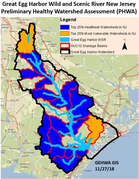
The PHWA corroborates the GEH River Council’s historic focus on the headwaters of the watershed to improve the performance of stormwater infiltration, reduce nonpoint source pollution and reduce impervious cover upstream to protect watershed wide water quality downstream.
With the establishment of the GEH River Council due to the Wild and Scenic Designation, there is a forever effort in place for local river managers to monitor the effectiveness of federal and State water quality measurement and protection, and to provide supplemental monitoring, analysis, investment, and advocacy to reduce pollution, and enhance the protection of water quality in the Great Egg Harbor Watershed.
GEH Watershed Association uses its mission to provide education and outreach opportunities
As we know, Partnership Wild and Scenic Rivers work diligently on protecting and improving the water quality of their rivers. Below Lynn Maun, Education Outreach Coordinator of the Great Egg Harbor Watershed Association, describes their work for Great Egg Harbor’s Water Quality.
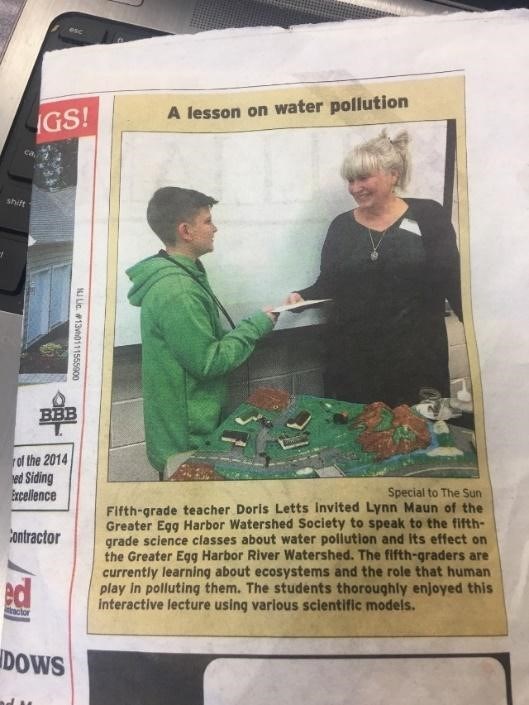
In the Great Egg Harbor Watershed’s (GEHWA) mission statement, it says we are, “to expand public awareness, education and appreciation of the watershed’s many valuable and unique resources.” To accomplish that goal, we engage with a diverse audience from middle school and college students to adults by providing programs that address threats to, and ways to, monitor and improve water quality.
Doris Letts, a 5th grade science teacher in the Williamstown Middle School in Monroe Township, NJ first invited the GEHWA into her classroom in 2015 to reinforce what her three eighty-minute classes had been learning about ecosystems and what role humans play in polluting them. After she shared what she was doing with the other 5th grade science teachers, the program quickly expanded to include all 21 - 5th grade classes. Since 2015, 2,569 students and 169 adults have learned about water pollution and its impacts on the Great Egg Harbor River and Watershed.
During the program the students learn that they can visit a unit in the National Park System just by visiting the Great Egg Harbor River which flows through Monroe Township. They travel on the river, via slideshow, from its beginnings in Berlin, NJ to where it empties into the Great Egg Harbor Bay. Along the way, they meet a few amazing animals that can be found in or near the river. After their journey, we talk about stormwater runoff and also embark on the discovery of a hidden resource, groundwater. We engage in discussions on how humans can have negative impacts to both the river and groundwater and then look at ways to improve and protect these vital resources.
