Last updated: April 17, 2023
Article
Volcanic Resources Summary—El Malpais National Monument

Photo courtesy of Larry Crumpler.
Introduction
El Malpais National Monument is a volcanic treasure trove—its young lava flows and cinder cones cover the landscape and tell the story of recent volcanic activity in the American Southwest.
The landscape within El Malpais National Monument is dominated by volcanic features produced during recent eruptions from the Zuni-Bandera Volcanic Field. The Zuni-Bandera field is notable for its lava flows of unusually large length and large volume and for its diversity of vent types and lava flow morphologies.
Zuni-Bandera Volcanic Field
The Zuni-Bandera Volcanic Field has experienced three periods of activity, but El Malpais National Monument is dominated by basaltic volcanic rocks erupted in the most recent phase.
-
The “old basalt flows:” The first phase of volcanism began 700,000 years ago and erupted a series of fluid lava flows
-
The Chain of Craters: The second period of volcanism, at approximately 150,000 years ago, produced a series of cinder cones known as the Chain of Craters. It's mostly to the west of monument boundaries, and the associated lava flows of Cerro Bandera (the northernmost cinder cone in the Chain of Craters) is within monument boundaries.
- The El Malpais phase occurred between 60,000 and 3,900 years before present in the Zuni-Bandera Volcanic Field. Most of the volcanic rocks in El Malpais National Monument were erupted during this interval.
El Malpais Phase

Zuni-Bandera Volcanic Field in El Mapais NM.
Click on the image above to open a larger file.
Five young basaltic lava flows make up most of the El Malpais landscape. These lava flows have a range of surface morphologies and were emplaced via a variety of processes. From oldest to youngest, these flows are the El Calderon, Twin Craters, Hoya de Cibola, Bandera, and McCartys flows. The McCartys Flow is the most scientifically importat, providing significant insight into lava flow processes. The lava flows were mostly produced during Hawaiian (effusive) eruptions (VEI 0). See, Volcanic Explosivity Index (VEI).
|
Flow |
Age (years before present) |
|---|---|
|
McCartys Flow |
3,900 |
|
Bandera Flows |
11,000 |
|
Hoya de Cibola Flows |
>11,000 |
|
Twin Craters Flows |
18,000 |
|
El Calderon Flows |
<60,000 |
After KellerLynn (2012) and Dunbar (2010). Young basaltic lava flows are notoriously difficult to date by available techniques, and the errors for these values are relatively large.
Mildy explosive (Strombolian) eruptions (VEI 1) also formed cinder cones such as Bandera Crater, Twin Craters, and El Calderon. Hoya de Cibola is a shield volcano that was formed from the buildup of lava flows.
Basaltic lavas do not produce explosive eruptions because they have low viscosity. Eruptions consisting of bursts of volcanic blocks, bombs and tephra, fire fountains, and small ash and cinder columns yield cinder cones and associated cinder fields. Coarser-grained material falls around vents to produce cinder cones or more widely during periods of higher explosivity.
The vent area for the McCartys Flow is a thick flow accumulation topped by a small scoria cone. Cinder fields surround at least two cinder cones (El Calderon and Bandera Crater). Although they are not an edifice, cinder fields present an environment and are landscape features akin to cinder cones as they are both made up of accumulations of mostly loose cinders. Some plant species such as cinders phacelia (Phacelia serrate) grow exclusively or preferentially in cinder substrates.
Cinder Cones, and Volcanic Vents and Edifices
Volcanic vents and edifices in El Malpais National Monument include cinder cones, a shield volcano, the elevated vent platform for the McCartys Flow, plus a few vents from earlier phases of volcanism. At least eight volcanic vents for the El Malpais phase are found within monument boundaries. An additional three vents from earlier phases of volcanism in the Zuni-Bandera field are also present in the monument.
| Vent (map unit) | Type | Notes |
|---|---|---|
| McCartys Vent (Qcm) | Elevated flow accumulation with small cinder cone | The cinder cone has been impacted as its use as a target in the World War II bombing range. Small explosive craters give it a “lumpy” appearance and it is littered with sharp metal fragments. |
| Bandera Crater (Qcb) | Cinder cone | The largest cinder cone in El Malpais National Monument, and a classic example of a breached cinder cone. |
| Bandera Cinder Field (Qvb) | Cinder field | |
| Hoya de Cibola (Qvw) | Shield volcano | Small shield volcano with vent at the summit. |
| Cerro Candelaria (Qct) | Cinder cone | Large cinder cone. |
| Lava Craters (Qct) | Cinder cone | Small breached spatter cone. |
| Twin Craters (Qct) | Cinder cones | A series of three small cinder cones over a fissure-like vent with a northeastern trend. |
| Lost Woman Crater (Qct) | Cinder cone | Large cinder cone with a smaller subsidiary cone to the north. |
| Twin Crater Mixed Pyroclastics and Flow (Qvt) | Mixed cinders and flows | Area mapped as cinder deposits and lava flows undifferentiated. May include additional vent areas. |
| El Calderon Crater (Qcc) | Cinder cone | Breached cinder cone. |
| El Calderon cinder field (Qvc) | Cinder field | Cinder field preserved in areas not covered by the El Calderon Flow on mostly the west side of the cinder cone. |
| Cerro Bandera (Qc) | Cinder cone | Part of the Chain of Craters eruptive phase. |
| Cerro Encierro (Qb) | Cinder cone | Formed a low edifice in what is now the northwestern part of the Hole-in-the-Wall kipuka. |
Cinder Cones

Photo courtesy of Larry Crumpler.
Cinder cones are small volcanoes that are the most common type of volcano on land. They have steep sides with either a conical, horseshoe, or elongated shape with craters filled by debris re-worked from the rim of the cone. They are made up of layers of loose or welded cinders, volcanic bombs and blocks, and ash that accumulated around a vent.
Cinder cones typically occur in fields. Each eruptive vent is monogenetic, meaning that it erupts only once. The Chain of Craters produced prior to the El Malpais phase of volcanism is a good example of a field of monogenetic cinder cones.
Cinder cone eruptions usually produce only a small volume of erupted material. While the cinder cones of Zuni-Bandera field are of average size (less than 660 ft; 200 m tall), the lavas flows erupted from the cinder cones are of larger volume than typical.
Most of the volcanic edifices in El Malpais National Monument are cinder cones. The El Calderon and Bandera flows were erupted from single vents associated with cinder cones. The Twin Craters Flows were erupted from several cinder cones in a very short period of time.
- El Calderon Crater is an approximately 200 ft (60 m) tall cinder cone that is breached to the northeast where rafted pieces of the cinder cone were carried away by the lava flow eruption. A cinder field covering 0.20 square mi (0.53 square km) was also produced during this eruption.
- At least four vents were active during the eruption of the Twin Craters Flows: Lost Woman Crater, Twin Craters, Lava Crater and Cerro Candelaria. Lost Woman Crater, Twin Craters, and Lava Crater are aligned on a northeastern trend, and Cerro Candelaria is east of Lava Crater. The four vents erupted within a short period of time. Field relationships demonstrate that the eruption of Twin Craters was followed by that of Lost Woman Crater and then by Lava Crater.

-
Cerro Candelaria and Lost Woman Crater are the largest of the cinder cones associated with the Twin Craters eruption, and are both approximately 360 ft (110 m) tall.
-
Twin Craters actually consists of three small cinder cones aligned on a northeast trend of a probable fissure-type vent. A smaller un-named cinder cone appears to be located north of Lost Woman Crater.
-
Lava Crater is a small spatter cone, which is a type of cinder cone that consists of cinders or pieces of lava that have been welded together as they were still molten when they landed, typically in low explosivity eruptions. This cone was breached to the northeast by a small lava flow.
-
Bandera Crater is an ideal example of a breached cinder cone. It was breached on the south side by the eruption of the Bandera Flows, with a collapsed lava tube also marking the direction of lava travel away from the vent. A large field of small cinders covering 1.5 square miles (3.9 square km) area surrounds the cinder cone on all but the south side with cinders covering sedimentary rocks and older basalt flows. Bandera Crater and much of the cinder field are in a private in-holding within monument boundaries.
Shield Volcano
Hoya de Cibola is the only shield volcano produced during the El Malpais phase of volcanism. It is a very small shield, being only approximately 1.5 miles (2.4 km) in diameter and 300 feet (90 m) high. The vent is located at the summit.
Other Vents

Photo courtesy of Larry Crumpler
The McCartys vent area consists of a very small cinder cone on top of a broad platform of lava flow accumulations and cinders. This vent area is unusual in that it lacks a significant volcanic edifice per se, but is also not a fissure. The central McCartys scoria cone is very small, with a diameter of approximately 246 feet (75 m), although the overall vent area is approximately 820 feet (250 m) wide.
At least three vent areas from older phases of volcanism in the Zuni-Bandera field have been documented in El Malpais. Cerro Bandera is a cinder cone that was active during the Chain of Craters phase of volcanism. The crater of this cinder cone is less distinct than those of the El Malpais phase of volcanism due to its older age.
Two vents for the first phase of volcanism in the Zuni-Bandera field are found within monument boundaries. One vent, Cerro Encierro, is in the northwest part of the Hole-in-the-Wall, a large kipuka with a volcanic substrate. Cerro Encierro is a small edifice approximately 140 feet (43 m) tall. Another vent on the west boundary apparently did not produce an edifice.
Lava Flows

NPS photo.
Basaltic lava flows are typically fluid and able to spread out and travel great distances from their vents. Pāhoehoe (ropy surface) flows are more fluid than ‘a‘ā (blocky) lavas, and travel at greater speeds. A pāhoehoe flow surface may transition into ‘a‘ā downstream, and an eruption may change from one type of lava to another. Both types of flows may be fed via channels and tubes.
El Calderon Flows
The El Calderon Flows are the oldest of the major lava flows found in El Malpais National Monument, and are less than 60,000 years old. The eruption of the El Calderon Flows marked the initiation of the El Malpais phase of volcanism. Lava traveled from the vent approximately 22 miles (35 km) to the northeast, although much of the original extent of this lava flow has been buried by younger eruptions.
Twin Craters Flows
The Twin Craters Flows likely erupted from four main cinder cones that were active within a narrow time range approximately 18,000 years ago. These flows are exposed in the northern part of the monument and appear to be the shortest in length of the five major lava flows in El Malpais National Monument. The Twin Craters Flows consist primarily of tube-fed pāhoehoe, but also contain channelized ‘a‘ā lava. They have lost much of their ropy pāhoehoe structure and the original glassy surface rind given their age.
Hoya de Cibola Flows
The Hoya de Cibola Flows are the only flows of the El Malpais phase of volcanism to be associated with a shield volcano. The other eruptions in the field either produced cinder cones such as El Calderon and Lost Woman Crater, or did not form a significant edifice, such as the McCartys Flow. Pāhoehoe lava flowed primarily east and southeast from the vent area, and probably also flowed to the northeast, but was buried by younger lava flows.
Bandera Flows
")
Photo courtesy of Larry Crumpler.
The second youngest lava flows in El Malpais, the Bandera Flows, are the only ones that consist mostly of ‘a‘ā lava, versus pāhoehoe. Blocky ‘a‘ā lavas have a rougher surface than pāhoehoe lavas and have an extremely rugged, jagged, and rubbly surface. The Bandera Flows also have an extensive network of lava tubes, collapsed lava tubes, and contain tree mold fossils. These flows retain much of their surface structures, but have lost their original glassy surface.
McCartys Flow

Photo courtesy of Larry Crumpler.
The McCartys Flow is the most recent lava flow in the Zuni-Bandera Volcanic Field, and is one of the youngest lava flows in the Southwest. It is approximately 3,900 years old. The flow is complex and was active over a period of many years. It was erupted from a vent area marked by an elevated platform of flow accumulations and a very small scoria cone.
The surface features of the McCartys Flow are very well preserved and it retains its glassy rind. The surface of the flow consists of ropes, slabs, ridge-and-furrow lineations, and lava shatter zones. Other structures on the flow includes squeeze-ups, lava blisters, and lava driblets. The upper few millimeters of the surface consists of black volcanic glass called tachylite. The margins of flows are characterized by “toes,” or lobes formed from breakouts, and may have several benches or levels. Lava Falls is a lava drip that formed during a breakout from one of the small lobes of the flow.
Inflation Structures

Photo courtesy of Larry Crumpler.
The surface of McCartys Flow is characterized by the presence of many large circular depressions, especially in the southern portion of the flow. These depressions were previously thought to be collapsed lava tubes, but recent research has shown that they are lava rise pits formed via inflation, formed by processes that only occur in pāhoehoe flows.
Pāhoehoe lava flows may either be emplaced via channels, tubes or as sheets. Much of the McCartys Flow was emplaced as sheets. Sheets are likely to form in large areas with very gentle slopes, and inflation is an important process for the emplacement of sheet flows. Flows inflate underneath cooled flow surfaces when lava supply is greater than the ability for a lava flow to spread laterally due to cooling at the flow margins. Inflation thickens the lava flow and produces a uniform uplift of the solidified surface.
Lava rise plateaus produced by inflation have been identified in the central and southern parts of the McCartys Flow, including in a large area near the vent and the region near Lava Falls. The plateau near Lava Falls was inflated more than 33 ft (10 m). The surface of inflated plateaus can be relatively flat, with only minor relief across distances of 330 ft (100 m).
Lava rise pits (also known as inflation pits) are un-inflated zones of an inflated plateau where the solid upper crust and hardened bottom surface of a lava flow were not separated by further injection of liquid lava. Lava rise pits may form when topographic obstacles beneath a lava flow exist, and where the flow is thereby thinner. The thinner area will solidify more quickly and be unable to inflate. The floors of lava rise pits may consist of broken slabs of cooled lava or may have been flooded by molten material from the pit margins during inflation.

Photo courtesy of Larry Crumpler.
Because they form via an entirely different mechanism, lava rise pits are rarely connected to significant subsurface voids, unlike collapsed areas of lava tubes. On the McCartys Flow, lava rise pits are commonly 33 to 66 ft (10 to 20 m) in diameter with steep margins characterized by deep cracks or clefts. Lava “squeeze-outs” may occur on the slopes leading towards the depression where fluid lava escaped via clefts in the cooled surface of the flow.
Tree Mold Fossils

NPS photo.
Tree molds are one of the few types of fossils that may be common in basaltic lava flows and are the most significant paleontological resources at El Malpais. Tree molds have been reported in the El Calderon, Bandera and McCartys flows in El Malpais National Monument.
Tree molds are only known from four other NPS units (Craters of the Moon National Monument, Lava Beds National Monument, Puʻuhonua o Hōnaunau National Historical Park and Hawaiʻi Volcanoes National Park).
Paleontological resources are irreplaceable records of past life and are protected by the Paleontological Resources Preservation Act of 2009.

Photo courtesy of Larry Crumpler.
kīpukas
kīpukas are areas of older geology surrounded by younger lava flows. The rocks seen in kīpukas at El Malpais may be of any rock unit in the monument except the McCartys flow—because it is the youngest lava flow.
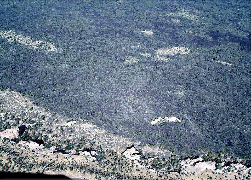
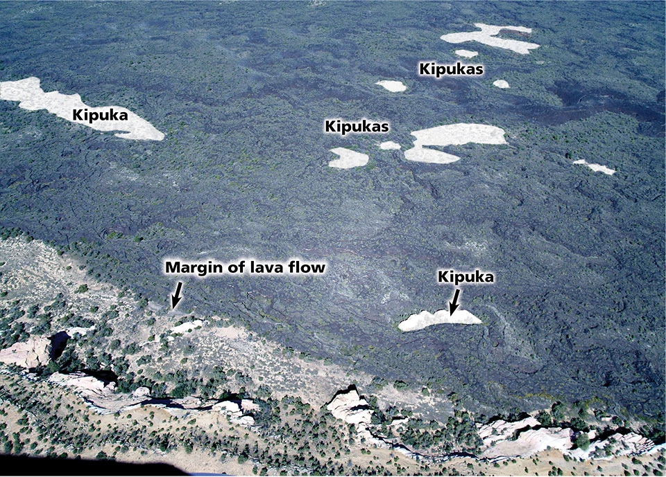
Left image
Small kīpukas near the margin of the McCartys Flow. Most, if not all of these kīpukas have a sandstone substrate and were likely topographic highs at the time of the eruption. El Malpais National Monument, New Mexico.
Credit: Photo courtesy of Larry Crumpler.
Right image
Image with feature labels.
Credit: Photo courtesy of Larry Crumpler, annotated by Allyson Mathis
El Malpais kīpukas are of three major substrate types:
-
Sedimentary
-
Eolian
-
Volcanic substrates, where the kipukas are made of older lava flows than the ones surrounding them.
The largest kīpukas (Hole-in-the-Wall and Cerritos de Jaspe) within the greater El Malpais area are mostly outside of monument boundaries. A good example of a large kīpuka completely within the national monument is Los Medanitos just north of Acoma-Zuni Trail. It was created when inflation lava flows from McCartys surrounded the much older lava of the Hoya de Cebola.
Kīpukas with volcanic substrates in the northeastern area of the monument are interpreted to consist of Hoya de Cibola flows on the basis of composition, flow similarity, vegetation and weathering.
Lava Tube Caves

Photo courtesy of Larry Crumpler.
El Malpais National Monument contains one of the longest lava tube systems in the world, with a cumulative length of more than 60 mi (95 km). The monument also contains the southernmost ice caves in North America.

NM and the major lava tubes. Click on the image
above to open a larger file.
At El Malpais, lava tube caves are mostly found in the El Calderon, Hoya de Cibola, Twin Craters, and Bandera lava flows, with at least one tube in older volcanic deposits. The lava tube caves are in 15 major cave/lava tube systems. Long sections of collapsed tubes also exist in the monument, and entryways into lava tube caves are often accessed by way of piles of rubble formed via breakdown processes.
Lava tube caves reveal important information about the emplacement of fluid lava flows, contain ice deposits, and contain rare secondary minerals.
Additionally, lava tube caves provide important habitat for bats, cave-dependent organisms, and have unique plant and invertebrate assemblages growing in moss gardens in entrances and skylights. These entryways and skylights provide distinct microclimates that differ from the rest of the monument and are similar to Arctic climates. Other microclimates exist in caves including in twilight, and dark zones and near ice bodies.
Caves in El Malpais National Monument are protected by the Federal Cave Resources Protection Act, which was passed in 1988 to “secure, protect, and preserve significant caves on Federal lands for perpetual use, enjoyment, and benefit of all people.”
Ice Caves

NPS photo.
Ice caves contain perennial or seasonal ice, and these ice deposits may be up to a few thousand years old and may provide important paleoclimate information. Additionally, the ice deposits are frequently associated with cultural resources as they have been utilized by people from pre-historic to historic times.

NPS photo.
Perennial or seasonal ice has been documented in at least 40 caves inside of El Malpais National Monument.
Because El Malpais caves are shallow, the temperature and humidity conditions inside of the caves relate to those at the surface. Both daily and annual cycles of temperature and humidity change are observed in the caves. Each cave has its own unique microclimate and relationship with conditions at the surface, and different sections of a single cave may also have their own unique microclimates. The deeper sections of a cave have less temperature variation than areas closer to the entrance.

NPS photo.
Breakdown refers to both the broken deposits of rock material from the ceiling and walls of caves and the rockfall and other mass wasting processes that deposit them. Breakdown covers the floors of many lava tube caves in El Malpais and the entrance into many caves is via piles of breakdown. Breakdown deposits may be as much as several meters deep in some lava tube caves.
Much of the breakdown at the entrances to, and in El Malpais lava tube caves and skylights likely formed during initial cooling of the lava flows, but the formation of breakdown is an on-going process. The ceilings and walls of lava tube caves are generally heavily jointed, decreasing their stability, and loose blocks may be found in cave ceilings.
Cave Minerals
Fourteen secondary minerals (or mineraloids) have been identified in El Malpais lava tube caves. Seven of these minerals are rare in cave environments, and El Malpais has some of the first occurrences of these minerals in caves. Most of the rare minerals in El Malpais lava tubes are Sodium-sulfates or Sodium-carbonates, including burkeite, thenardite, and trona.
These minerals often are part of fragile speleothems such as angel hair, powder, “snowballs,” or part of moonmilk, which is a white deposit with a "cottage cheese-like", tufted or fibrous texture present in a few El Malpais caves. Some of these minerals, such as mirabilite, may undergo seasonal changes as Sodium-sulfate minerals may dissolve under wet conditions.
Fossils
The lava tube caves in El Malpais contain a variety of undated vertebrate skeletal remains, packrat middens and other evidences of life. Some of the bones are found deep in caves and may have mineral coatings. Perennial cave ice deposits may contain Holocene twigs like those recovered from Candelaria Ice Cave.
The vertebrate skeletal remains and packrat midden deposits are found on the rocky surfaces of the cave floors, and it is impossible to know whether the remains are modern or pre-historic without the availability of absolute age determinations. But given the preservation capability of lava tubes caves, they likely contain significant Holocene fossils.
Geoheritage Values

NPS photo by Nick Guarino.
The volcanic terrain of the Zuni-Bandera field has also shaped nearly every aspect of the monument’s natural and cultural history.
Geologic resources are literally the bedrock of units in the National Park System, but their relationship to other park resources are especially evident at El Malpais. Geology makes up the scenery and the landscape that is integral to the significance of most natural areas within the system. Paleontological resources are irreplaceable records of past life and are protected by the Paleontological Resources Preservation Act of 2009. Geologic processes continue to shape park landscapes, impact park ecosystems, and may present hazards to park infrastructure and human safety.
Geology serves as the foundation of ecosystems and is a major determinant of topography, water and soil chemistry, fertility of soils, stability of hillslopes, and flow regimes of surface water and groundwater. These factors, in turn, influence biology, including the distribution of habitats and the locations of threatened and endangered species. Geology also influences human settlement patterns and how people use natural resources—for farming, ranching, industry, construction, hunting, fishing, and recreation.
Geologic resources make up our geoheritage. The National Park Service defines geoheritage as “the significant geologic features, landforms, and landscapes characteristic of our nation which are preserved for the full range of values that society places on them, including scientific, aesthetic, cultural, ecosystem, educational, recreational, tourism, and other values” (NPS 2013).
Research Importance

Photo courtesy of Larry Crumpler.
Research into the mechanism of basaltic lava flow emplacement has occurred on the McCartys Flow since the 1930s. This research has had important implications for understanding lava flows on Mars and the Moon. The McCartys Flow is well-suited for study because it is one of the largest young lava flows on the planet, is well preserved with small-scale features retained, and occurs in a simple setting of a broad, sloping valley floor.
Detailed work on the McCartys Flow has been key in understanding the emplacement mechanism of the lava flow, providing new insight into the formation of basaltic lava flows, including whether lava flows on Mars or the Moon may have undergone inflation. By serving as an analog for lava flows on other planetary bodies, McCartys Flow is allowing researchers to identify and map specific surface features such as lava rise pits and flow margin terraces that may be found in inflated planetary lava flows.
The McCartys Flow meets the criteria of a scientifically and educationally significant geoheritage site per the Geological Society of America definition (Geological Society of America 2012).
Lava Flows and Plants
The landscape of El Malpais National Monument consists of young basaltic lava flows with little soil development, cinder cones and cinder fields, and small areas of sedimentary rock substrate. As a result, strong alliances between bedrock geology and vegetation exist, and are a key aspect of the lava flow-influenced ecosystem of El Malpais.
The earliest ecological studies of the El Malpais region noted the strong influence of the young volcanic features on the region’s vegetation, as evidenced by stands of stunted or deformed Douglas-fir (Pseudotsuga menziesii), and ponderosa pine (Pinus ponderosa) growing on the Bandera and McCartys flows.
Important biogeographic aspects and characteristics of the monument’s vegetation include ancient trees growing on the young lava flows, the endemic plant cinders phacelia, and the vegetation communities found on kipukas.
Rare Plants

NPS photo.
Cinder phacelia (Phacelia serrata) is an endemic species that grows on volcanic cinders in only two areas: the San Fransisco Peaks in Arizona, including Sunset Crater Volcano National Monument, and in El Malpais National Monument.
Populations of cinder phacelia plants are present at several cinder cones in the monument. It is considered to be a US Fish and Wildlife Service species of concern because of its rarity.
Ancient Trees

Photo courtesy of Grant Harley.
El Malpais contains some of the oldest living trees in the southwest. These trees, along with dead wood found on the young lava flows, were essential in the establishment of the longest tree ring chronology in the American Southwest, which extends from 136 BCE to 1992 CE. The ancient trees used in the chronology were from two areas of the Bandera lava flows.
The young lava flows of El Malpais offer an unusual and harsh habitat for trees and they typically grow in a stunted form on them. Very old living Douglas-fir and ponderosa pine trees grow on the rough surfaces of the Bandera and McCartys lava flows in a unique environment. The lava flows concentrate moisture in fractures that provide suitable growing conditions for these deep-rooted trees. The lack of soil development on these young lava flows along with the lack of grasses inhibit wildfires, which is a major factor in allowing these trees to survive to very old age.
Old pinyon pines and Rocky Mountain junipers are also present from the McCartys flow, with the oldest trees being more than 400 years old.
The ancient trees of El Malpais are scientifically important, and are likely being threatened by climate change impacts. In recent years, these trees have shown signs of stress, and a 600-year old Douglas-fir died in 2014.
Vegetation Growing on Kipukas

Photo courtesy of Larry Crumpler.
The vegetation growing on kipukas at El Malpais National Monument are strongly influenced by bedrock geology as kipukas may be made up of sedimentary rocks, eolian deposits, or older lava flows. But because the most recent volcanism in El Malpais was nearly 4,000 years before present the vegetation growing on the kipukas has not been influenced by volcanic activity, as the vegetation in the park is younger than the lava flows.
World War II Bombing Range

Photo courtesy of Larry Crumpler
Between late 1942 and May 1944 (well prior to the establishment of the national monument, a 9-square mile (23-square km) area of lava flow around McCartys Crater was used as the Kirtland Demolition Bombing Range for training using live munitions from the Kirtland Army Airfield. The “somewhat lumpy” appearance of the McCartys scoria cone results from small detonation craters from explosives.
The lands within the former World War II bombing range were incorporated in El Malpais National Monument when it was established in 1987. In the late 1980s, several 45-kg (100-pound) general purpose bombs and a bomb tail fuse were blown in place by US Army Explosive Ordnance Disposal specialists. Additional bomb removal actions around McCartys Crater have been taken on behalf of the US Army Corps of Engineers.
Source
Valentine-Darby, P., A. Mathis, K. Struthers, D. Shorrock, L. Baril, and N. Chambers. 2016. El Malpais National Monument: Natural resource condition assessment. Natural Resource Report NPS/SCPN/NRR—2016/1301. National Park Service, Fort Collins, Colorado. https://irma.nps.gov/DataStore/Reference/Profile/2233380
Related Links
-
El Malpais National Monument (ELMA), New Mexico—[ELMA Geodiversity Atlas] [ELMA Park Home] [ELMA npshistory.com]