Last updated: April 7, 2025
Article
Restoring the Cultural Landscape at Palo Alto Battlefield
National Center for Preservation Technology and Training
This presentation, transcript, and video are of the Texas Cultural Landscape Symposium, February 23-26, Waco, TX. Watch a non-audio described version of this presentation on YouTube.
National Park Service
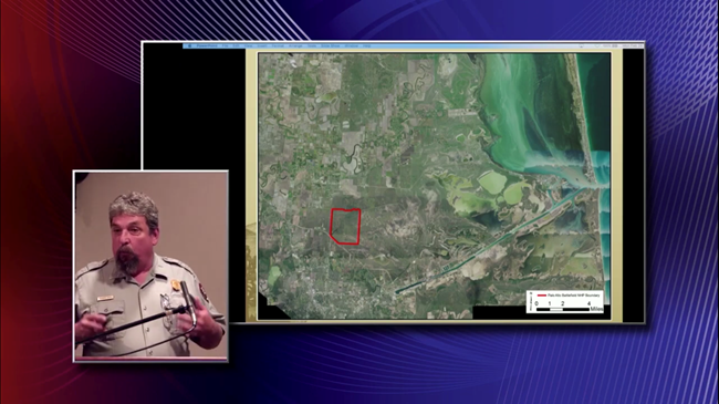
Rolando Garza: I will talk today about our efforts to restore the cultural landscape and how it impacts our visitor experience. Palo Alto Battlefield is the only national park that is dedicated to preserving and interpreting sites associated.with the US Mexican War, 1846 to 1848. Right now we have a Palo Alto Battlefield and Resaca de la Palma Battlefield and there is legislation in Congress to expand our boundary to include the earthen ruins of Fort Brown.
What started on these fields in the Rio Grande delta would lead to events that would forever change the face of the North American continent and forged a relationship between these two young republics, with Mexico ceding over half of its national territory to the United States. So this is undeniably significant to both of our countries, and it's part of our history that isn't, especially in the United States, isn't well remembered or well understood. So it is an important site. That's about all the history I'm going to give right now. So please come visit the park, come visit Brown's ruin and the battlefield. I promise you a personal tour of the site, if y'all come down. Okay. You can call me on that.
National Park Service
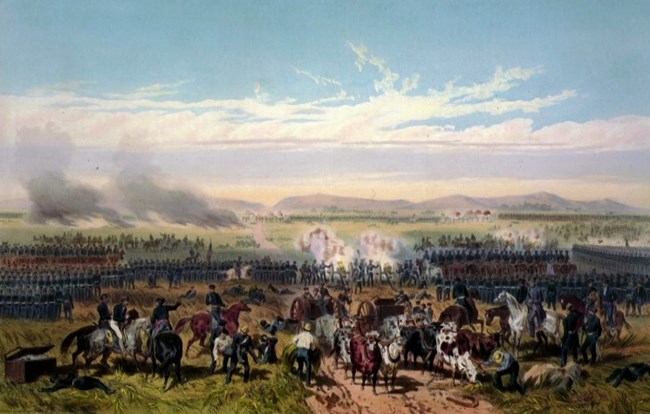
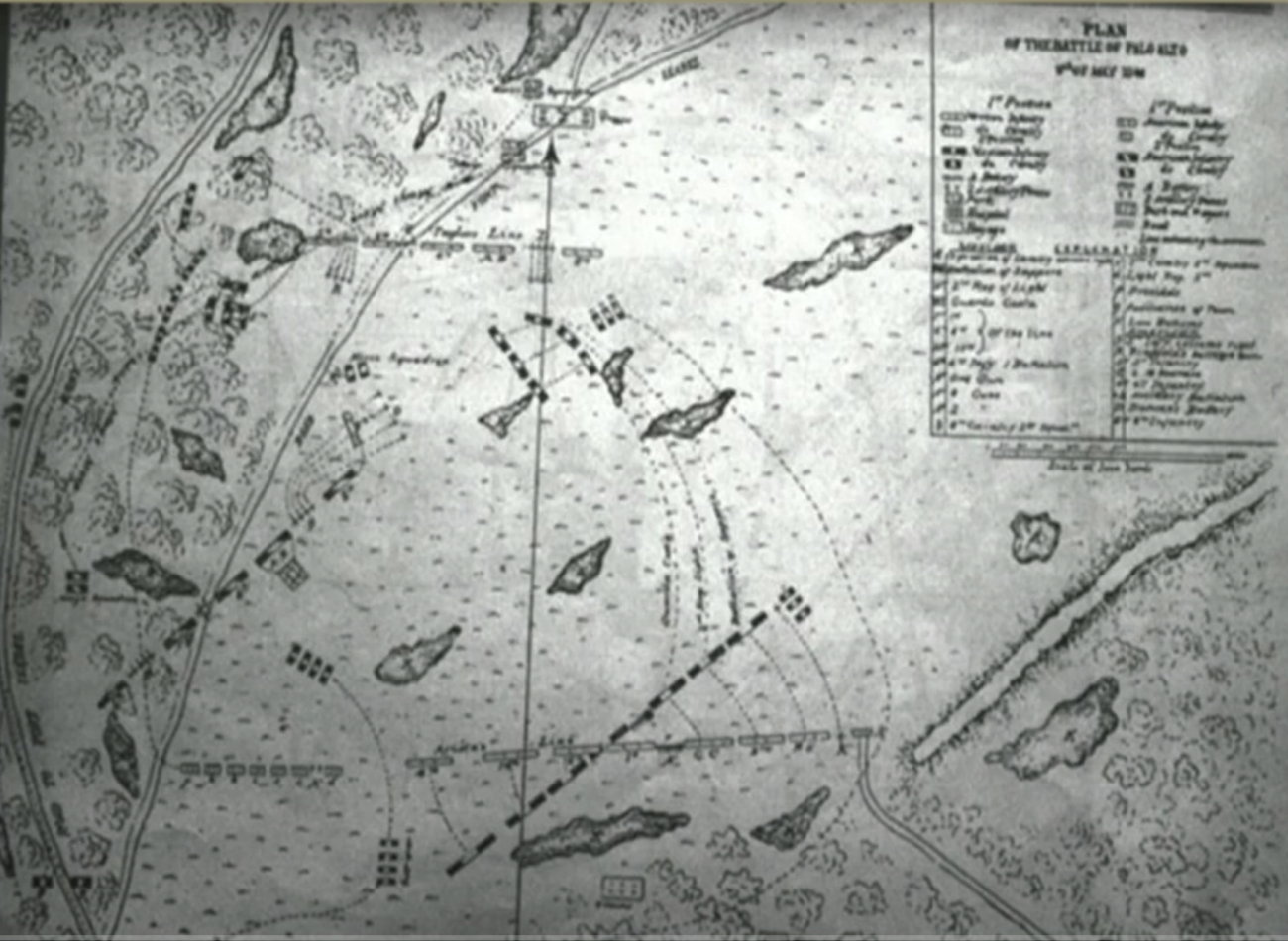
So, we know how the battle unfolded. We know the salt prairie, we have the historic records. The enabling legislation of 1992 gave us a 3,400-acre boundary and we know it's on the salt prairie. It conducted a lot of archeology to determine where the core battlefield was. Between 1992 and 2000 we really didn't own any property, so we spent a lot of time researching, which was very nice because we have a good, good foundation. But if you see this picture, it's probably one of the most, of period lithographs, it's probably one of the most accurate depiction of what it looked like at one of these battlefields. Most of them are really stylized and don't really represent. Of course, you got to take away the mountains because if you come to Brownsville, there's going to be no mountains there.
But this war really ushered out the Napoleonic era of warfare. You had two big armies sitting on a salt prairie lined up against each other, with Mexican army still wearing their shackles and their dress uniform with bright blues and bright reds, while the US army was a little more in fatigues, but they were still lined up, still following the tactics, but they had some major innovations, especially with artillery and flying artillery.
National Park Service
Now the battlefield of Palo Alto is largely unchanged from 1846, because it's sitting at the edge of the Coastal Prairie and it wasn't good for crop cultivation and marginal for livestock grazing. That said, 20th century cultural activities have impacted the cultural landscape and the setting. In the '92 legislation, Congress charges the park to restore and maintain the historic character of the site, cultural landscape, right? We have a problem, starting at the beginning of the 20th century, about 1910, Cameron County, Hidalgo County and Williamson County, all the region in South Texas on the US side, started huge drainage projects in reaction to the hurricane of 1898 and all the large scale flooding that lasted for months down there. So the hydrology's really changed and then you add the damming of the Rio Grande River. The Rio Grande delta does not flood like it used to and the coastal prairie and the salt prairie, which can take water on it for months, does not flood, which has allowed native, woody vegetation to encroach upon the battlefields.
Then you bring mid-20th century land management activities directly related to that. I'll go through a series of maps here. In 1939 you don't have a lot of activity out on the battlefield, but these land clearing and attempts at crop cultivation and cattle grazing, which has really impacted the cultural landscape and natural vegetation communities.
It was 1939 still open, 1950 we began to see bigger scars. That's a gas pipeline running through, but it's still kind of a wide open prairie. Then comes the second half of the 20th century; 1962 you get roads in, you get these cultural lines. You get this, these cultural lines in the salt prairie up there, where they've removed vegetation. You see even more, all the way up there. These are all cultural lines that impact the landscape and you get this big field up in here, which is outside of the core battlefield so we reforested that and let that go. And then you can even see more. They just continue, the latter part of the 20th century really impacted the battlefield by removing the salt prairie.
This prairie in an historic account Ulysses Grant talks about about the grass comparing it to darning needles piercing the skin. If you walk out in cordgrass it does. I've never had a pair of pants that it won't go through. So that's what we are dealing with. Do you see lines right here that come in in the 1970s? They're still there today. That's because cordgrass on its own does not fill in, it doesn't migrate. It grows in clumps, it doesn't have rhizomes. So that's one of our biggest challenges in restoring the cultural setting, being accurate, but also we need the cordgrass for fire, which is going to be the most efficient management tool we have.

National Park Service
So this is the modern day map. This is showing what we own and what we don't own. And so since this is a private in holding still, we're only concentrating on this part of the core battlefield. We've done intensive archeology, so we know where the core battlefield stops. And so everything over here west, we're just going to leave nature take its course. Let it fill in with brush. It will act as a buffer for us, for the sound, for the highway right here, for this highway. We won't be able to see it and it will cut down some of the sound. And then it'll also serve as a habitat for cats and ocelots, we do have an ocelot. We don't have a big enough area to have a breeding population, but we have had some transitory ocelots come through, but bobcats, coyote. That other habitat is going to be valuable for that. Meanwhile, we'll concentrate on preserving and restoring the cultural landscape on the core battlefield.
Like they said earlier, it takes a village. I'm the only resource person in the park. And so I depend on partnerships, and as you see here, I really rely... thanks to Joel Wagner who's a hydrologist with water resources division in Fort Collins, his persistence and keeping a partnership. This project here is called the Resaca Restoration and adjacent coastland prairie. It partners with Colorado State University, David Cooper, he's a wetland ecologist, and USDA NRCS plant materials center director, John Lloyd-Reilley. We're trying to discover the most efficient way to reintroduce cordgrass, because like I said, it's accurate but it's going to give us the tool to keep woody vegetation at bay without having it progress.
But also, started with a resaca restoration, which is right in there. Let's see, here's a map of the area. In the 1950s during a major drought, they put these two livestock tanks and they dug ditches on the inner side of the resaca here and throwing the spoil pile on the outside, making these artificial levees. So, the resaca wouldn't function naturally like it did and then plus, impacting the cultural landscape by changing it. This resaca, during the battle, and here I go talking about history again, during the battle, the Mexican Calvary was trying to outflank the Americans on the west and they crossed this twice. It slowed them down because they didn't really see it. It just looked like ground. But then it had water bodies in it, and it slowed them down, allowing the American artillery to position itself and repel them from there.
Before we did any ground moving, we did some backhoe trenching just to see where the historic natural ground level, the historic levy was, compared with the spoil pile. In this we also determined that this resaca... how many of you all know what a resaca is? That's a pretty good amount. A resaca is an abandoned channel, main channel or distributary channel of the Rio Grande delta system. So we determined, based upon the science, that this was abandoned about 500 years ago. And naturally what happens as you see through some of those aerials, they fill in. They only hold water in times of tropical storms or heavy rain.
So, this is what it looks like. These are the artificial levee's berm. This is the resaca back here, and this is a tank right there, and then these are the berms that stop. We've pushed all that in and now we have an even flow where the broad prairie flows, sheet flows, into the resaca basin, like it should be doing naturally.
National Park Service
This is the result and now the native vegetation has come back on here, but also, we have a problem. Like I said, woody vegetation, cattle grazing has allowed woody vegetation, and then the changes in hydrology, to encroach upon the battlefield. And this is where it was bare earth. We had cattle here, came up. It should look like this where there hadn't been all the vegetation. This is cordgrass. This is that private inholding, right there. This is the fence. This is all good cordgrass prairie and that's what it should look like. If you notice there are few trees out there, but that's natural. It's the area that's been highly disturbed where mesquite and [___] will rush in and invade. All those other trees were about 20 years old. I'll show another picture of them right now.
In 2016 we partnered with the US Fish and Wildlife. We're going to mechanically reduce the brush on the prairie. We got a big roller chopper. The park put in about $25,000, Fish and Wildlife matched that with about $45,000, and the reason they're interested in restoring the prairie on Palo Alto is because of the aplomado falcon. An endangered species that's recovering and this is in the heart of their territory right there. They have a Fish and Wildlife coastal program out of Corpus and they benefit. We have a breeding pair of aplamados on the Eastern part of the park.
Well, we had a big roller chopper machine and we were able to clear all the brush in that one area. It leaves it down like this. Where you're actually you drive with little buggies or carts that we have, UTVs, without having to worry about puncturing tires or anything like that. And that's cordgrass right there. We had areas that once looked like this, you see that natural gas pipeline sign? Now look like that.
Chris Helzer, The Nature Conservancy
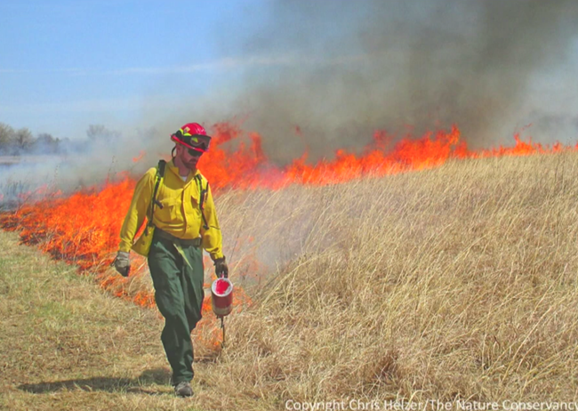
Areas that looked like that, now look like that, wide open. So, what has to be cleared, we do the mechanical treatment at first. Next spring you get all these young sprouts coming out. So we've got to herbicide treat them. We do the basal bark, which is training. Basal bark you get a concentration of vegetable oil, about 75% to 25% Garlon 4, and you just coat the first about from the knee high down, get a good coating around and it's about 90% effective. The next spring, 10% of the trees will come back.
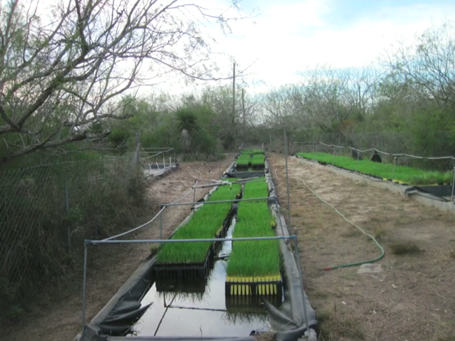
Watch we do it systematically. Come in and we do it. Get ready. But also while we're doing this, because this is the area... a lot of the area we're doing this is without cordgrass. There's a large part of the core battlefield where the cordgrass was totally removed. There's some areas that still has it. So we are working on reintroducing gulf cordgrass. Like I said, we're working on trying to find the most efficient way to reintroduce it. The tried and true way is getting grass plugs, splitting them and then growing them in containers and putting them out. We've also been working on gathering seeds. We've been gathering seeds from the official wildlife Bahia Grande Unit, which they do fires regularly, and we find out those seeds have a much higher germination rate because the grasses were burned the year before and so when they come back in the spring, the seeds produce much better because they've been in shock and so we collect those. We actually taken them up to USDA, they process the seeds and then we send them up to a vegetable grower in San Antonio and we get nice little plugs like that.
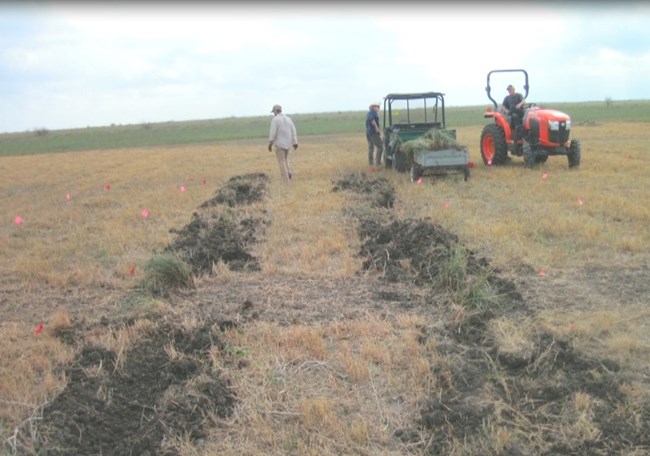
And then we plant them in there. This was planting back in 2016, maybe this one. And this is what it looks like. There was no cordgrass out here at all. After three years, it's coming back. It looks nice. It looks much better in person, believe me, and then this was just last week. So we're moving on. This year we're planting about 50 to 60,000 plugs, but what's really exciting about this year, we're finally doing seeding experiments, our different experiments in there with seeding. Do you see all those flags? Those are all little plots. This is one... we're supposed to get these clumps of cordgrass, then put them through like a bale buster, but because of the dirt, that really wasn't working right? So we decided to use this method and dig a little trench, put them in there and do that. But we're also doing a seeding experiments.
National Park Service
That looks like a big bag of seeds, right? The seeds are real small, so we have to mix it with cornmeal and husks from seeds and all that. The seeds are real small and we want to spread them out evenly throughout the plot, so we have to have filler with it. And so we're doing it by hand. First we do it by hand, strictly on the ground in different plots. And then we're using a seed drill to put them in. This is what it looks like. Kind of some weird instrument, I don't know what from. But it's pretty cool. That and then we have watered some plots are watered, some aren't. It's half and half. It's all, these guys, John Lloyd-Reilley and David Cooper, decide the design this experiment. It wasn't me. I'm only an archeologist.
Anyway, this is the tool. We need to do all this. We need to get cordgrass, but this is the tool that's going to efficiently keep the woody vegetation at bay, because we'll never be able to bring back the hydrology. The other thing about the cordgrass, when it's dense, after heavy rains, tropical storms, it will hold the water up near the surface a lot longer. We did experiments at the very beginning with little sensors that test the hydrology in the ground, and the plots that had dense cordgrass, the water would stay at the ground surface a lot longer, which also would help to keep the plants at bay. But the fire is really going to be the main tool for us.
So that way when visitors come to see the park, they can experience like the soldiers saw it, but also be able to envision a wide-open prairie and imagine two 19th century armies facing off, which really helps us to interpret the battlefield. And thank you for your attention.
National Park Service
Rolando L. Garza (M.A., University of Texas at Brownsville) is the Archeologist and Chief of Resource Management at Palo Alto Battlefield National Historical Park in Brownsville, Texas. After receiving a B.A in Anthropology from the University of Texas in 1990, he worked on various Cultural Resource Management projects throughout Texas and New Mexico, including a stint serving as Field Director for the Texas Department of Transportation on the Freedman’s Cemetery project in Dallas.
n 1998, Garza joined the National Park Service at the Southeast Archeological Center, gaining invaluable experience investigating battlefields from the American Revolution, the War of 1812, and the U.S. Civil War, as well a variety of other historic and prehistoric sites in the Southeast Region. He returned to his hometown in 2001 to work at recently established national park.
Since his return, Garza has directed a number of archaeological investigations at Palo Alto Battlefield as well as at the associated Mexican War sites of Resaca de la Palma, and the original earthworks at Fort Brown. He has also participated in archeological investigations on the nearby Civil War era Palmito Ranch Battlefield National Historic Landmark. He is an active steward of the archeological resources in Cameron County and serves on the Brownsville’s Historic Preservation Design and Review Board and on the Brownsville Historical Association’s Board of Directors.
