Last updated: March 29, 2021
Article
Hawai'i Volcanoes National Park: World Heritage Site

NPS photo.
Hawai’i Volcanoes National Park is located on the island of Hawai’i – the southernmost, and largest island in the Hawaiian island archipelago in the north central Pacific Ocean. The entire archipelago was formed, and is still in the process of formation, by volcanic activity over a “hotspot” in the Earth’s mantle.
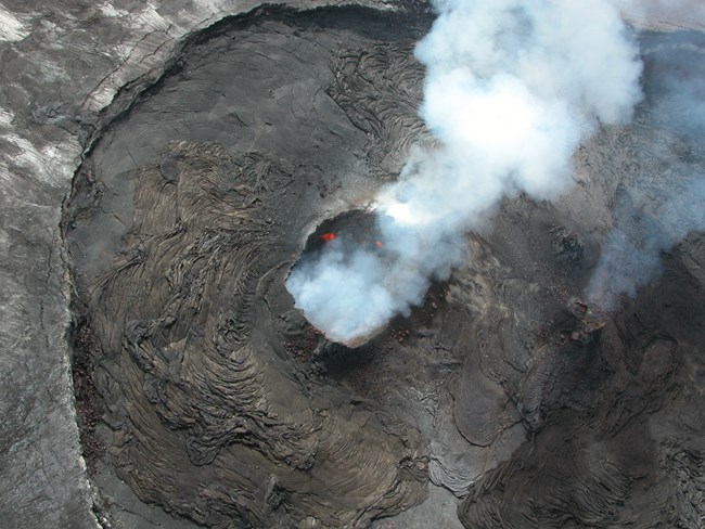
The World Heritage Site contains two massive volcanoes -- Mauna Loa and Kilauea, two of the world's most active and accessible volcanoes where ongoing geological processes are easily observed. A program of scientific volcanic study aides this understanding under the direction of U.S. Geological Survey scientists at the Hawaiian Volcano Observatory.
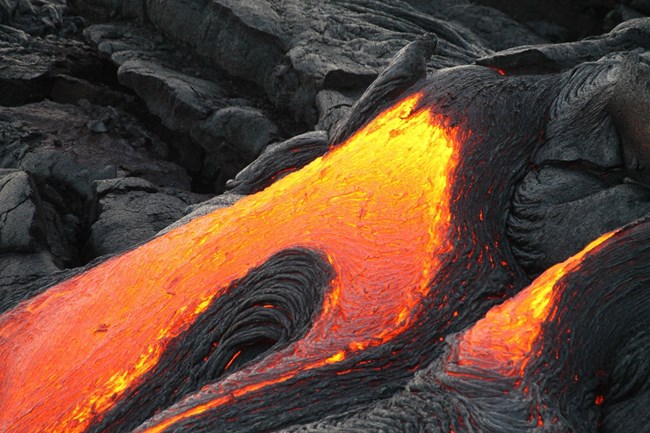
This World Heritage Site encompasses the summit and part of the southeast flank of Mauna Loa volcano and almost a third of Kilauea volcano. These broad, flat volcanic domes rarely explode. Occasionally, they send up fountains of molten rock hundreds of rneters into the air. Measured from the ocean’s floor, these volcanoes constitute the greatest volcanic mass on earth.
Each year, more than 1.6 million people visit the 1,350 square kilometer (520 square mile) park to experience the volcanoes and the park’s other natural and cultural features. Designated as a Biosphere Reserve and a World Heritage Site, Hawai'i Volcanoes National Park preserves the intimate connection between the natural history of the region and Native Hawaiian culture –- a culture that to this day reveres the island volcanoes as sacred places.

NPS photo by Gwen Gerber.
Over 1,600 years ago, Polynesians from the Marquesas Islands migrated 2,400 miles to Hawai'i in double-hulled canoes using the Sun and stars for navigational guides. They brought various survival items including pua'a (pigs), moa (chickens), roots of kalo (taro), uala (sweet potatoes), and ko (sugar cane) in the canoes. Then, about 800 years ago, Polynesians from the Society Islands arrived in Hawai'i. These Polynesians claimed descent from the highest gods and became the new rulers of Hawai'i. For a time, the Polynesians traveled back and forth between the Society Islands and Hawai'i until contact with southern Polynesia ceased. Just as the millions of years of isolation the land of Hawai'i experienced permitted development of its unique flora and fauna, the next 400 years of isolation for the Polynesians resulted in a unique Hawaiian culture.
The many archeological sites and historic districts within the park pay tribute and attest to the unique Hawaiian culture that developed during this time. Sites include petroglyphs, historic trails, fossilized footprints, shelter caves, scattered remains of heiau ruins (temple), house platforms, and stone walls of canoe sheds, pens, and corrals. Many of these sites are listed in the National Register of Historic Places.
The Pu'uloa Petroglyph Field, which is located in the Puna-Ka’u Historic District on the Puna-Ka’u (Puna Coast) ancient trail, is the largest concentration of rock carvings in the park. The area contains over 23,000 petroglyphs. A boardwalk provides visitors an easily accessible way to view them. Many of the petroglyph carvings are ancient with forms that are mainly dots with rings, human figures, sails, and circles with attached lines.

Public domain.
The Footprints Area in the park preserves intact fossilized footprints of Native Hawaiians associated with the eventual rise of Kamehameha as the ruler of Hawai'i. As Kamehameha was working toward controlling the Hawaiian Islands, he met resistance on his home island of Hawai'i from some of his distant family members, including a man named Keoua. In 1790, while en route through the Kau Desert to battle the forces of Kamehameha, part of Keoua’s warrior party died from an explosive eruption of Kilauea. The crater ejected a huge, dense cloud of ash, sand, and rocks, which rained down killing many things in its path—including some of the Native Hawaiians in Keoua’s army. As the ash settled to the ground, it provided an excellent medium for fossilizing footprints. Visitors can access the Footprints viewing area by either following the Kau Desert Trailhead adjacent to Highway 11 or the Kau Desert Trail from Crater Rim Drive.
The historic Wilkes Campsite is a European-American heritage site in the park. Charles Wilkes and the U.S. Exploring Expedition began their excursion to conduct experiments at the summit of Mauna Loa in 1841. Due to wayward leadership and being unprepared, only nine remained of the 300-person party of Americans and Hawaiians once Charles Wilkes made it to the summit. Despite this, the intended experiments were completed on January 11, 1841. Wilkes’ campsite is the only known evidence of the U.S. Exploring Expedition in the Pacific.
For visitors to the park, the Jaggar Museum offers information about scientific and historic discoveries in the field of geology and volcanology (the study of volcanoes). Visitors to the Jaggar Museum can also enjoy a stunning panoramic view of the Kilauea Caldera, one of the world’s most active volcanoes. Visitors interested in the 1790 Footprints have the opportunity to literally walk with history: the footprints of men, women, and children that are now preserved under protective glass.
Hawai'i Volcanoes: https://www.nps.gov/havo/index.htm
World Heritage Information: http://whc.unesco.org/en/list/409
