Article

The Historic American Buildings Survey's 90th Anniversary

In celebration of the 90th anniversary, on November 10, 2023 an exhibition opened at The Athenaeum of Philadelphia titled “Blazing the Trail: The Historic American Buildings Survey turns 90.” The exhibition highlights the past decade of HABS projects and the use of emerging technologies that place HABS on the forefront of architectural documentation practice. Each project represents different challenges and applications to best suit the resource. The exhibition opening coincided with the 40th annual Peterson Prize award ceremony to honor the student awardees for the best set of measured drawings. The following day, a symposium, “Documentation by Design: A Celebration of The Historic American Buildings Survey 90th” was held. The presentations set the context for HABS achievements past and present, while also looking toward the future. The following represents a condensed version of the exhibit to underscore those achievements.

For ninety years, the Historic American Buildings Survey (HABS) has been the at the forefront of recording America’s rapidly vanishing built environment, embracing buildings ranging from the architect-designed and monumental to the humble vernacular to tell all American stories. Over 45,000 buildings and sites are now represented in its archive of measured drawings, photographs, and historical reports.

Established during the Great Depression, HABS was a call to action spurred by the loss of America’s early architectural landscape, a concept that remains relevant today. It was the first time that the federal government took action to recognize and protect the nation’s architectural legacy. It also laid the groundwork for many preservation initiatives to come, establishing practices and concepts such as field survey, listing, and providing information on historic sites for the public benefit.
Black and white image of a graphic reading: “Blazing the Trail: The Historic American Buildings Survey turns 90”
Now entering its tenth decade, HABS continues to be a leader in the profession. Holding to our mandate to continually test new recording technologies, methods such as terrestrial laser scanning, digital photogrammetry, and (soon to be released) high-resolution born-digital photography now form the backbone of our field recording process. Every project pushes the envelope in new and different ways.

In this article, you will see how HABS has adapted these new technologies to our workflow, as well as some of the challenges faced along the way. You will also see how HABS continues to expand the breadth of its collection: from the addition of once-cutting edge Mid-Century Modern designs, to the critical task of recording and preserving sites pivotal to the American Civil Rights Movement.

The history of the built environment is inextricably intertwined with the stories of the people who constructed and used it; HABS documentation thus serves as a mirror, reflecting the nation’s achievements and aspirations, successes, and failures, as well as our everyday lifestyles and folkways.

Ellis Island Main Hospital
New York Harbor, New York 2014

Color laser scan images showing an exterior elevation above a building section. Both of these images are above a black and white floor plan.]
Composite image showing, from top to bottom: exterior scan data, interior scan data, and floor plans derived from the scan data and hand measurements.

Image by HABS

Historical Significance

HAER Architect John Wachtel (top) and HABS Architect Daniel De Sousa laser scanning the basement corridor.
HAER Architect John Wachtel and HABS Architect Daniel De Sousa laser scanning the basement corridor.

Image from HABS

The Main Hospital on Island 2 was constructed in three phases between 1900 and 1909 for the Immigration Bureau of the Department of Commerce and Labor in consultation with U.S. Marine Hospital and Public Health Service (US-MHPHS) surgeons assigned to medical inspection at the Ellis Island U.S. Immigration Station. Immigrants arriving at Ellis Island needing general medical attention were treated here, as well as groups eligible for USPHS care such as merchant seaman. The Main Hospital included a maternity ward, operating rooms, an x-ray laboratory, and later a dental clinic.

Technology: Creating a “Backbone”

Color image of a point cloud showing a section through a stairwell showing how floors relate to each other.
Section through the scan data showing deterioration in one of several stairwells. Scanning vertically through stairwells helped establish the relationship between floors.

Image from HABS.

By the early-2010s HDP had acquired a laser scanner that could perform a scan in 15-20 minutes that would have taken the previous generation of scanner nearly an hour to complete. But it was still not fast enough to justify scanning every single room in a building—a team measuring by hand can take the necessary dimensions in five minutes. So at the Hospital at Ellis Island, we used a hybrid method on the interior: we scanned the center corridors and main staircases and measured individual rooms by hand. The hand measurements were then attached to the framework or “skeleton” of accurate scans to produce complete floor plans and sections.


Learn More

See the HABS documentation of the Main Hospital building and other historic sites at Ellis Island, part of the Statue of Liberty National Monument in the HABS/HAER/HALS Collection in the Library of Congress here.


Fort Jefferson
Dry Tortugas, Florida 2015
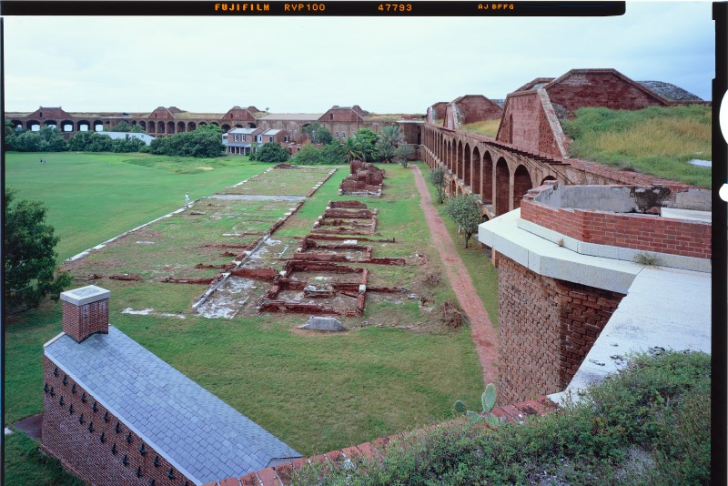
Color large-format HABS photograph showing the Parade Ground of Fort Jefferson. The fort buildings and walls are made of red brick and surround a grassy parade ground with some buildings in ruins.
Parade Ground of Fort Jefferson, surrounded by tiers of open casemates built into the walls. In the foreground is the hot shot furnace where cannonballs were heated to a red hot state so as to set wooden battleships ablaze, and ruins of the Officer’s Quarters and kitchens.

Todd Croteau, Photographer.

Historical Significance

Fort Jefferson was built to fortify the harbor of the Gulf of Mexico and to serve as an advance post for ships involved in maritime trade. Although begun in the late 1840s, it was still incomplete in the 1860s when Florida announced its secession from the Union, followed months later by the outbreak of the Civil War. Fort Jefferson then served as a coastal blockade for Union naval forces and as a military prison. Advancements in weaponry quickly made Fort Jefferson obsolete, and the military abandoned it in 1874.
(Left) Color field photograph showing a man standing on a roof operating a piece of surveying equipment. (Right) Color image of a point cloud showing an aerial view of Fort Jefferson with numerous survey points.
(Left) HABS Architect Paul Davidson collecting targets for the control network using a surveying Total Station. (Right) A rendering of the point cloud showing the numerous stations that needed to be tied together with the control network.

Images by HABS

Technology: Dealing With Large Sites

For very large sites, using a surveying total station to create a fixed network of targets increases both efficiency and accuracy. While a laser scanner is itself a highly accurate piece of technology, a total station is an order of magnitude more accurate, because it is designed specifically to take individual measurements over extremely long distances. Instead of connecting laser scans only to each other via shared targets, it is possible to attach them to a network of total station targets that are given priority over scan-to-scan targets in the software. This increases the overall accuracy of the assembled point cloud.
Color image of an assembled point cloud showing a cut-away section through large masonry building with very thick walls and an arcade with a barrel vault roof overhead.
Point cloud rendering of the Large Powder Magazine cut in section, showing the heavily reinforced barrel arches meant to protect the ammunition stored there.

Image by HABS

Learn More

See the HABS documentation of Fort Jefferson and other historic sites at Fort Jefferson National Park in the HABS/HAER/HALS Collection in the Library of Congress here.


Fort Jefferson – Harbor Light
Dry Tortugas, Florida 2015
Color image of an assembled point cloud showing an elevation of the fort consisting of rows of red brick arches. The image transitions into a cut-away section through a lighthouse and a large masonry bastion.
Point cloud rendering showing a section cut through the Harbor Light and Bastion 6, upon which it sits.

Image by HABS

Historical Significance

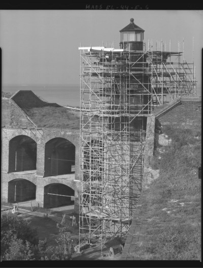
Black and white HABS photograph showing several levels of metal scaffolding surrounding a historic lighthouse.
View of the Harbor Light scaffolded for repair.

Jarob Ortiz, Photographer.

The iron Tortugas Harbor Lighthouse was built in 1876 to replace the original 1825 brick lighthouse located on what is now the Parade Ground. Construction of the new lighthouse was prompted by a severe hurricane that came through the area in 1875. Rather than repair the original brick structure, a stronger iron lighthouse was erected atop the bastion, increasing visibility.

Technology: Going Back for More

Colorized point cloud showing of a portion of Fort Jefferson as seen from above. The image shows the parade grounds, moat that surrounds the fortress, and location of the lighthouse.
Perspective point cloud rendering showing the Harbor Light in the context of the Fort.

Image by HABS

A benefit of creating a total station network at a site is that, if we leave behind permanent markers, we can return to a site and use them to tie new laser scans into an existing dataset. In this case, we returned to Fort Jefferson to scan the Harbor Light several months after we had done the initial scans of the Fort itself. Because we were able to locate total station markers from our first visit, we could attach the new Harbor Light scans to the original Fort scans.

Learn More

See the HABS documentation of Harbor Light and other historic sites at Fort Jefferson National Park in the HABS/HAER/HALS Collection in the Library of Congress here.


Cape Hatteras Lighthouse
Buxton, North Carolina 2016

Color image of a point cloud showing a landscape with various paths, trees and a lighthouse with a painted with a spiral stripe. The lantern on top of the lighthouse is incomplete as it is missing laser scan data.
Aerial perspective view of the point cloud. Note the lack of detail in the lantern, which was at the edge of our scanner’s ability to record.

Image by HABS

Historical Significance

Cape Hatteras Lighthouse is an important aid to the navigation of the Atlantic Coast: the Diamond Shoals that extend up to ten miles out from Cape Hatteras, coupled with the Gulf Stream currents, earned this area its reputation as the “graveyard of the Atlantic.” A lighthouse was first established here in 1803, heightened in 1853, and finally replaced with the current lighthouse in 1869-70. Due to the intense need for visibility at long range, Hatteras is the tallest brick light tower in the United States. For recognition during daylight, it is painted with distinctive black and white spirals. The lighthouse was first documented by HABS in 1989, prior to being moved due to coastal erosion.

Technology: Vertically Challenged

(Left) field photograph showing a man standing on a catwalk, wearing safety equipment. (Center) Black and white image showing the lantern and details captured through the photogrammetric process. (Right) CAD drawing showing the lantern in detail.
(Left) HABS Architect Paul Davidson taking images of the cast iron supports using a
digital SLR camera attached to a pole. (Center) Photogrammetric model of the intricate, cast iron supports below the lantern catwalk. (Right) Detail of the lantern, based off of a of laser scan & photogrammetry.

Images by HABS

At Cape Hatteras we faced the problem of trying to capture the top of the lighthouse while only being able to scan from the ground. We experimented with several longer-range scanners than the ones we normally operate, but none were very successful in capturing the level of detail we needed to draw the intricate ironwork. Ultimately, we settled on photogrammetry. We took the images from the lantern balcony, using with a camera attached to a long arm.

Learn More

See our virtual tours, panoramic photos, and animations of high-definition point cloud data, of the Cape Hatteras Lighthouse here.

See the HABS documentation of the Cape Hatteras Lighthouse and other historic sites at Cape Hatteras National Seashore in the HABS/HAER/HALS Collection in the Library of Congress here.


National Zoo – Reptile House Washington, DC 2017
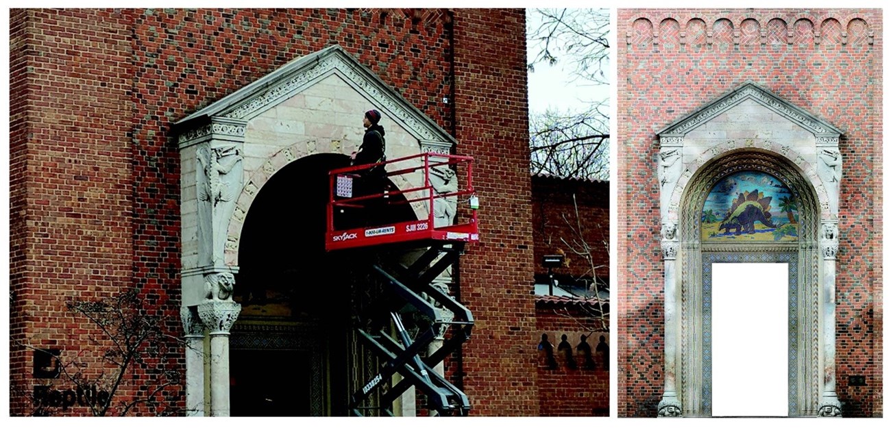
(Left) Color photograph of a man on top of a raised scissor lift to capture architectural details of the entrance portico. (Right) Color ortho-rectified image showing the detail of the elaborate and colorful entrance portico.
(Left) HABS Architect Paul Davidson using a scissor lift to capture the thousands of photos necessary to build a photogrammetric model of the entrance portico. (Right) The final ortho-rectified image of the entrance portico, derived from photogrammetry.

Images by HABS

Historical Significance

As director of the National Zoological Park from 1925 to 1956, Dr. William M. Mann sought to transform it from a menagerie-style collection of animals to a world-class institution. Completed in 1931, the Reptile House evoked scientific progress, world exploration, and a fascination with the exotic. Its Byzanto-Romanesque design, a departure from the earlier zoo buildings, was a collaboration between Director Mann and Washington, D.C. Municipal Architect, Albert Harris. The brick exterior is enlivened with cast stone snakes, lizards, and frogs, and a colorful prehistoric scene in concrete mosaic above the front door. Likewise, it provided then state-of-the-art environments for reptiles in captivity, with each cage including a diorama of the environment from which the reptile came. It became a model for American zoos throughout the 1930s, demonstrating that the National Zoological Park was an influential, first-rate public institution.

Technology: Photogrammetry

Color photogrammetric rendering of a several sculptural elements on the façade of the Reptile House with several black and white targets and long color rectangular scale bars temporarily attached to a brick wall.
Photogrammetric rendering of sculptural details on the façade of the building. The use of shared black and white targets allowed us to join the laser scan and photogrammetric data sets together. Also note the long rectangular scale bars.

Image from HABS

Photogrammetry is the process of generating reliable, measurable data from two-dimensional photographic images. While HABS used film photogrammetry in the 1980s-90s, we did not begin investigating digital photogrammetry until the mid-2010s. At the Reptile House, we used this technology to capture details that were not only sculptural, but whose colorful, mosaic-like attributes would be difficult to convey with black and white line drawings alone. At the same time, we began experimentingwith using color images on HABS drawing sheets. Due to concerns that the images alone would not be sufficiently legible on certain sheets, CAD linework was also provided.

Learn More

See the HABS documentation of the Reptile House and other historic sites at the Smithsonian's National Zoological Park in the HABS/HAER/HALS Collection in the Library of Congress here.


Hollin Hills – Model 2B42LB
Fairfax County, Virginia 2017

Black and white HABS photograph showing a large open living room with sofa and chairs on a rug and a wall of glass windows.
View showing the open living area, featuring an expansive glass wall of windows.

Justin Scalera, photographer

Historical Significance

Built in 1953, this house represents the most popular prototype created by locally prominent architect Charles Goodman (1906-92) for his progressive mid-century modern subdivision of Hollin Hills. Built between 1946 and 1956, Goodman’s Hollin Hills houses used standardized plans and prefabricated modular unit construction. Although only eight “unit types” were developed, by changing the orientation to fit the natural topography, and utilizing optional rooms and design features, it is rare that any two houses look exactly alike. Situated in lush, rolling, and wooded terrain, Goodman worked with renownedlandscape architect Dan Kiley to blend the houses with the natural environment.

Collection Highlight: Modernism

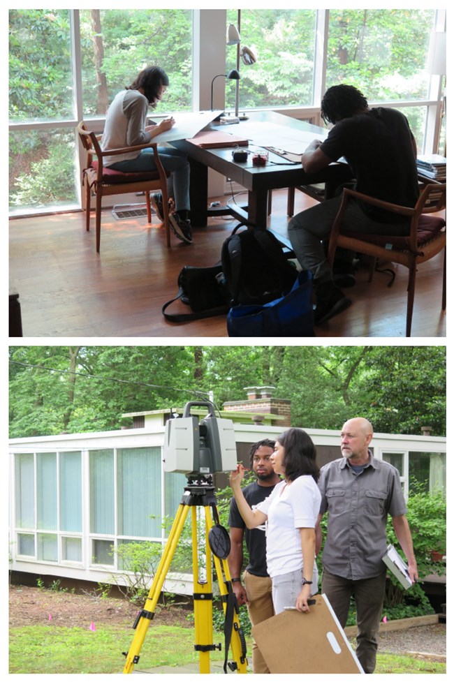
(Top) Color photograph showing two people sitting at a dining room table sketching. (Bottom) Color photograph showing a woman standing next to a laser scanner programming it while two men watch her input parameters on the screen.
(Top) HABS summer interns receive training in traditional hand-sketching and measuring techniques in conjunction with laser scanning. (Bottom) HBCU intern Taurean Merriweather (left) and LHIP intern Emelyn Najera (center) run the laser scanner under the supervision of HAER Architect Dana Lockett.

Photos from HABS

As time marches on, buildings that were once considered the forefront of contemporary design mature into the category of historic architecture. HABS is committed to documenting all of America’s architectural heritage—not only the very old or the very grand. Hollin Hills is just one example of structures from the mid-20th Century that we have recently added to the collection. It was an exciting project for the students from the Latino Heritage Internship Program (LHIP) and Historically Black Colleges and Universities Internship Program (HCBUI) who recorded it.

Learn More

See the HABS documentation of Model 2B42LB and other historic houses in Hollin Hills in the HABS/HAER/HALS Collection in the Library of Congress here.


ANC Memorial Amphitheater Arlington, Virginia 2018

Rectangular bas-relief panels with figures, arms and armor, fasces and other neo-classical details.
Bas-relief panels depicting arms and armor, bundled rods known as fasces symbolizing unity, and figures.

Render by Paul Davidson

Technology: Photogrammetry

At Arlington National Cemetery’s Memorial Amphitheater, we used digital photogrammetryto document a vast array of highly sculptural ornament.
Ortho-rectified image of a monumental highly decorated white marble pedimented doorway with columns and other neo-classical details.
Monumental, pedimented doorway with carved tympanum above, depicting arms and armor.

Render by Paul Davidson

Tripod-mounted terrestrial laser scanners are not suited for this work, and while high-resolution, handheld laser scanners exist, we have found that digital photogrammetry is often a better way to capture these kinds of details. When processed correctly, it can provide higher resolution, higher accuracy, and better native color than laser scanning.In our workflow, a series of overlapping photos are taken of a subject and fed into specialized software. This software uses these overlapping two-dimensional images to generate highly precise three-dimensional models. The use of scale bars in the images means that these models are also measurable.We then generate images from these models that are ortho-rectified—that is, they are “head-on” or “planar” views that do not have any perspective or lens distortion. The images on this panel are examples of ortho-rectified scans from Memorial Amphitheater.
Ortho-rectified image showing the intricate details of a white marble Corinthian capital.
Corinthian capital of an engaged column.

Render by Paul Davidson

Learn More

See the HABS documentation of the ANC Memorial Amphitheater and other historic site at Arlington National Cemetery in the HABS/HAER/HALS Collection in the Library of Congress here.


Civil Rights Trail Various locations in Alabama 2019

Color HABS photograph showing main front elevation of a symmetrical orange brick church with gothic arch windows and belfry.
Façade of the Dexter Avenue King Memorial Baptist Church, Montgomery, Alabama.

Jarob Ortiz, photographer

Historical Significance

HABS documented twenty-two sites that are part of the Alabama African American Civil Rights Heritage Sites Consortium. They include National Historic Landmarks such as the Sixteenth Street Baptist Church, a site of civil rights meetings that was bombed by the Ku Klux Klan in 1963 killing four young girls and prompting international condemnation of segregation; and the Dexter Avenue King Memorial Baptist Church where pastor Martin Luther King organized the Montgomery Bus Boycott that led to the desegregation of city buses.
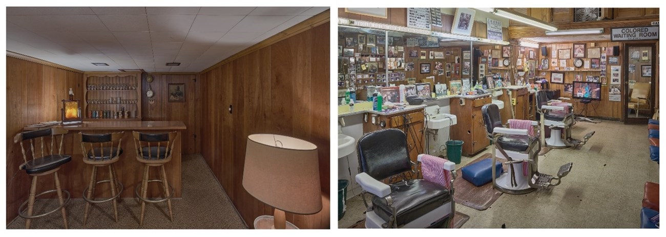
(Left) Color HABS photograph showing a wood paneled carpeted room with wood bar and stools. (Right) Interior of the Malden Brothers Barber Shop at the Ben Moore Hotel in Montgomery, Alabama.
(Left) Secluded bar in the home of Dr. Richard Harris. (Right) Interior of the Malden Brothers Barber Shop at the Ben Moore Hotel in Montgomery, Alabama.

Jarob Ortiz, Photographer

More grassroots sites include the Ben Moore Hotel and its barber shop, one of the first hotels to cater to Blacks and a regular meeting spot for civil rights leaders. Other sites were the homes and safe houses of civil rights activists, including the Safe House Black History Museum, with the mission to to preserve the unique culture and history of the rural, black belt south; and the home of Dr. Richard Harris, proprietor of the only Black-owned pharmacy in Montgomery, that provided a safe haven and meeting place for the “Freedom Riders” of the Montgomery Bus Boycott.


MLK Jr. Life House Atlanta, Georgia 2020

Color image of an assembled point cloud showing a section through the basement, main floor and attic of the house.
A cutaway of the assembled point cloud, showing the house in section. Note the basement spaces converted to offices for the King Center.

Image by HABS

Historical Significance

This was the family home of Dr. Martin Luther King, Jr. and Coretta Scott King starting in 1965. Instead of moving to a middle-class Atlanta neighborhood or suburb, they chose a ca. 1933 house in Vine City, a predominantly poor neighborhood on Atlanta’s west side. While in decline during the 1960s, Vine City was also close to King’s alma mater, Morehouse College, and home to other black professional and civil rights leaders. The Kings hired African American architect Joseph W. Robinson to design two ambitious renovation efforts between 1964 and 1968 that transformed the 1930s cottage into a 1960s ranch house with a two-car garage, a master bedroom suite addition, and basement recreation room and offices. This was the only house the Kings ever owned, and it immediately became a center of their civil rights work. Dr. King lived here until his assassination in April 1968 and his wife Coretta Scott King until 2004, raising their four young children and, in 1968, starting the King Center in its basement offices.

Collection Highlight: Civil Rights Sites

(Left) HABS photograph showing the elevation of a split-level brick house that is partially banked into the ground at the end of a driveway. (Right) Point cloud showing the house and surround landscape features from above.
(Left) View of the front elevation from the end of the drive. (Right) Point cloud rendering showing the site from above.

(Left) Jarob Ortiz, Photographer. (Right) Rendering by HABS

Architectural rarity or significance are not the only—or even the main—criteria for inclusion in the HABS collection. Historical and cultural significance can be equally important. Martin Luther King Jr.’s family home is unassuming and not notably different from any of the other suburban houses on tree-lined Sunset Avenue, but it was an epicenter of the Civil Rights Movement both during his life and for decades after his assassination.

Learn More

See the HABS documentation of other historic sites at Martin Luther King, Jr. National Historic Site in the HABS/HAER/HALS Collection in the Library of Congress here.


Beatty-Cramer Farm House Frederick County, Maryland 2020

HABS photograph showing a split-level wood farm house on a hill with a stone foundation, red roof and brick chimneys. A smaller stone smokehouse painted white is to the left.
View showing the Beatty-Cramer farm house and spring house. The current exterior completely obfuscates the original split-level design.

Justin Scalera, photographer

Historical Significance
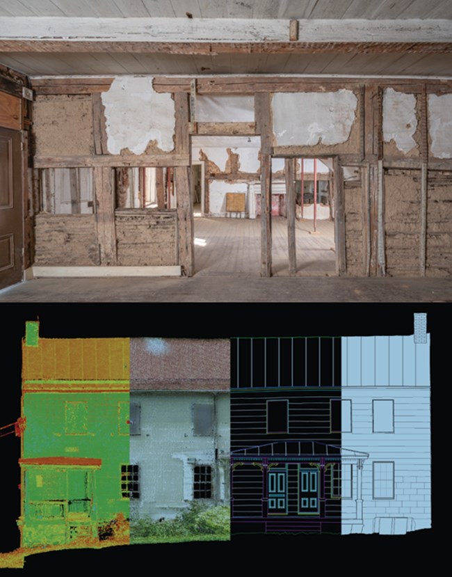
(Top) heavy timber-framed walls filled with “Dutch biscuit.”  (Bottom) Composite image (left to right): point cloud colored with intensity value data, a photo-textured point cloud with real world colors, AutoCAD rendering, and the final HABS drawing.
(Top) View of the first floor interior, showing the heavy timber-framed walls filled with “Dutch biscuit.” (Bottom) Composite elevation showing, the point cloud colored with intensity value data, the photo-textured point cloud, AutoCAD rendering, and the final printed drawing.
Highly unusual for Maryland, the Beatty-Cramer House was built in 1748-52 for Thomas Beatty and his Dutch wife, Maria Jensen, following the building traditions typical of the Dutch settlements from which they had migrated. Their house exhibits the heavy timber, transverse “H-bent” construction emblematic of Netherlandic framing, featuring posts connected by an anchor beam to form an H-shape. The framing is infilled with Flemishbond brick nogging, originally exposed on the exterior. An interior partition wall is formed by horizontal riven lath with earthen infill known as “Dutch biscuit.” Evidence also exists ofan original bi-level or “Opkamer” plan.

Technology: Speed Demon

HABS recently acquired one of the newest-generation laser scanners, the RTC360, which is fast enough to efficiently scan interiors room by room: it can complete a 360-degree scan in less than two minutes, far faster than hand-measuring. At Beatty-Cramer we used the larger and slower (but longer-range and more accurate) P50 to scan the exterior, while the RTC360 made quick work of the interiors.


Kennedy Center Washington, DC 2021

Color HABS photograph at dusk showing the exterior of the Kennedy Center lit with rainbow colored lights. A reflection of the colorful structure can be seen in the Potomac River.
Kennedy Center with 2021 Honors lighting, from Georgetown.

Jarob Ortiz, Photographer

Historical Significance

The Kennedy Center for the Performing Arts is the official national memorial honoring 35th U.S. president John F. Kennedy. It is an iconic example of the work of Edward Durell Stone, an internationally recognized master architect of the Modern Movement. It reflects a form of modernism known as New Formalism that used classical elements and strict symmetry to create monumental buildings.
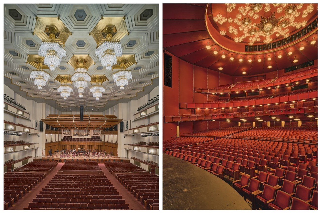
(Left) Interior of the Grand Foyer with a multistory-high ceiling, chandeliers, and red carpet. A bust of President Kennedy. (Right) Red interior of the Opera House, orchestra level and three balconies capped with ceilings and light fixture in gold.
(Left) Concert Hall House and Stage from chorister seats. (Right) Opera House from Stage right.

Jarob Ortiz, Photographer.

It features an exterior of Carrera marble veneer, large curtain walls, and steel columns with applied fins. Despite initial characterization of the building as a cross between a candy box and a marble sarcophagus, it is regarded as “an inspired and inspiring catalyst for the capital’s cultural life.”The Kennedy Center complex was recorded in acknowledgement of its 50th anniversary, creating color photographs and a historical report while preserving select original and renovation drawings on HABS title block.


Hirshhorn Museum Washington, DC 2022

A wide horizontal open-air courtyard with a water fountain with stones and reflecting overhead light panels.
View looking across fountain to courtyard wall of museum.

Jarob Ortiz, Photographer

Historical Significance

A curved utilitarian space with multiple tall pull-out panels holding paintings.
View into fourth floor art storage area.

Jarob Ortiz, photographer

The Hirshhorn Museum of contemporary and modern art and its Sculpture Garden were conceived as the United States museum of contemporary and modern art as a compliment to the National Gallery of Art, which focused on the great masters of Dutch, French, and Italian art. It was made possible through a generous donation by Joseph H. Hirshhorn of his private collection and stands on the National Mall as part of the Smithsonian museums. The building, now a Modern icon, was designed by architect Gordon Bunshaft of Skidmore, Owings and Merrill. Featured in the museum are the works of such noted twentieth-century artists as Pablo Picasso, Henri Matisse, Mark Rothko, Jackson Pollock, Francis Bacon, Milton Avery, and Edward Hopper while the outdoor Sculpture Garden contains works by Auguste Rodin, David Smith, Alexander Calder, and others.


Painted Churches Hawaii 2022

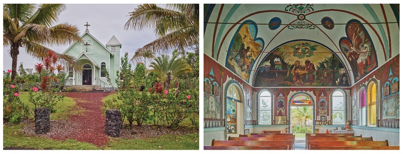
(Left) a small wooden church with a belfry on the side. (Right) interior of a church with colorful religious paintings on the walls and ceiling
(Left) Facade of Star of the Sea Painted Church in Kalapana. (Right) : Interior of the Star of The Sea Painted Church in Kalapana with decorative interiors by Father Evarist Gielen, painted in 1927-28.

Justin Scalera, Photographer

Historical Significance

HABS photographed two simple, gothic-influenced Hawaiian churches beautifully embellished with hand-painted interior murals. St. Benedict’s Painted Church in Honaunau, built in 1899, includes murals depicting scenes from the bible and lives of saints painted in 1899-1902 by Father John Velghe. Star of The Sea in Kaimu features decorative interiors by Belgian Catholic missionary priest Father Evarist Gielen, who also oversaw construction of the church, in 1927-28. The Star of the Sea paintings tell the story of Father Damien, a Belgian priest who helped leprosy patients on the island of Molokai and later died from the disease himself.


Art Deco and Modern Hawaii, Hawaii 2022
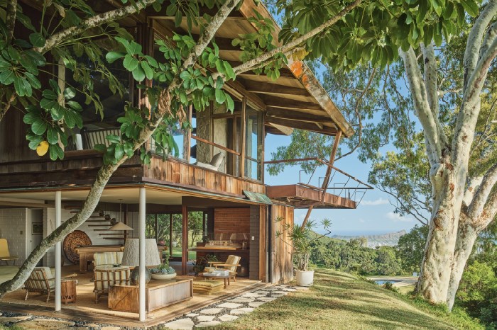
A wood house large overhangs, multiple windows and open space.
View of the airy Liljestrand house and its dramatic viewshed toward Punchbowl Crater.

Justin Scalera, photographer

Historical Significance

Working in concert with the local AIA, HABS identified noteworthy buildings in Hawaii to photograph for the collection. They range from religious and residential to industrial and governmental buildings. Many were in Modern styles indicative of the period of development in the region.
A small vernacular building on a corner with a modern skyscraper behind.
View of the Gumps Building in the foreground, Galleria Office Tower in the background, downtown Waikiki, Hawai’i.

Justin Scalera, Photographer.

Overlooking downtown Oahu is the stunning Liljestrand House, built in 1952 and designed by Vladimir Ossipoff with a ground level open to the outdoors. The Gump Building, built 1929, and designed by architect Hart Wood, is the last original commercial building in downtown Waikiki. Behind it is the office tower built in 1966 for the Bank of Hawaii, designed by local architect George J. Wimberly featuring a tropical lattice façade inspired by Polynesian motifs. The 1934 Honolulu Center Fire Station, designed by C.C. Dickey and John Mason architects of San Francisco, is built of reinforced concrete with aluminum garage doors in Art Deco motifs replete with the department’s insignia.


Rio Vista Farm Socorro, Texas 2022

Two deteriorated adobe brick buildings.
View of the distinctive parapeted gable ends of the adobe brick buildings for the Poor Farm and later repurposed to house various operations of the Bracero Reception Center.

Justin Scalera, photographer.

Historical Significance

The Rio Vista Bracero Reception Center is the best preserved of numerous such complexes established by the Mexican Farm Labor Program to bring workers into the U.S. from Mexico. Operating between 1951 and 1964, the program supplied nearly one-quarter of U.S. agricultural workers and significantly impacted Mexican immigration and post-war increases in the Latino population.
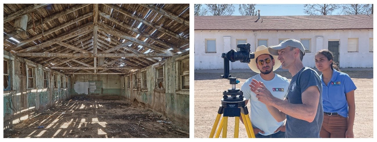
(Left) ruinous interior condition of a building with a deteriorated roof and rubble on the ground. (Right) Group of three people standing near a camera on a tripod. (Right)
(Left): Interior of one of the adobe brick buildings. (Right) HABS Architect Paul Davidson (center) explaining how to take a 360-degree panorama to LHIP interns Steven J Esparza (left) and Allison Toro Villada.

(Left) Justin Scalera, Photographer. (Right) Robert Arzola, Photographer.

Braceros or “helping hands” were processed and temporarily housed here before placed on farms. The Mission Revival adobe brick buildings were built in 1935-36 as the El Paso County Poor Farm, with frame dormitories added when leased by the federal government as a Braceros site in 1951. Documentation of the site was undertaken with the assistance of Latino Heritage Internship Program (LHIP) participants Steven J.Esparza and Allison Toro Villada.


West Texas Various Locations in Texas 2022

A modernist church with a unique curved roof with angular walls in a desert landscape.
Perspective view of the Temple Mount Sinai Synagogue.

Justin Scalera, Photographer

Historical Significance

While in El Paso on the Rio Vista Bracero project, HABS photographed twenty sites in and around the city, recommended by local preservation organizations. Many were commercial buildings within the downtown associated with the local Latino population, such as those in the Duranguito neighborhood, which is one of the oldest in downtown El Paso. Religious buildings included the modest adobe La Isla Church, built for a local farming community, and the eye-catching 1962 Mid-Century Modern Temple Mount Sinai synagogue designed by Los Angeles architect Sidney Eisenshtat. Examples of civic architecture include the Presidio County Courthouse in Marfa. The work of influential local architect Henry Charles Trost was also photographed, including his own Prairie Style house. Short form historical reports will be prepared by students from Texas A&M University at El Paso’s Historic Preservation Department to accompany the photographs into the collection.
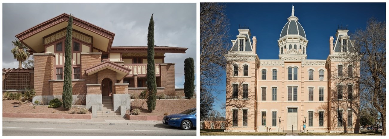
(Left) horizontally massed house made of thin tan bricks and a large overhanging roof. (Right) three-story symmetrical coral painted building with slate-roofed corner turrets and central dome.
(Left) Street view of architect Henry Charles Trost’s self-designed, Prairie Style residence. (Right) Front façade of the Presidio County Courthouse in Marfa, Texas.

Justin Scalera, Photographer


Heritage Documentation Programs (HABS/HAER/HALS): Documenting America's Built Environment

The Heritage Documentation Programs (HDP) consist of the Historic American Buildings Survey (HABS), Historic American Engineering Record (HAER), and Historic American Landscapes Survey (HALS). The programs document historic sites and structures across the United States through the creation of measured drawings, large-format photographs, and historical reports. Documentation is archived in the HABS/HAER/HALS Collection at the Library of Congress and is available to the public without restriction. HDP is part of the National Park Service’s Cultural Resources, Partnerships, and Science Directorate.

Learn more about the history and work of the Heritage Documentation Programs by visiting our website here.

Black and white logo of a column capitol with the letters H, A, B, S, across it with the number 90 incorporated into it. The column capitol is encircled by the words Historic American Buildings Survey 1933 – 2023.

HABS/HAER/HALS Collection

The HABS/HAER/HALS Collection at the Library of Congress is the nation's largest archive of historic architectural, engineering, and cultural landscape documentation. It is an active collection that grows each year. The collection includes measured and interpretive drawings, large-format black & white and color photographs, written historical and descriptive data, and original field notes. The collection is designed to permanently record the breadth of American places, and to make this documentation available as widely as possible. As of 2023, more than 45,000 sites are included in the collection. Materials created for HABS, HAER, or HALS are in the public domain.

Search the Collection

Search the HABS/HAER/HALS Collection at the Library of Congress.
Historic photograph of three well-dressed men measuring large, fluted columns. The words “Roger W. Moss Symposium, Documentation by Design” and “November 10-11, 2023” appear on the photograph.
Photograph of Historic American Buildings Survey (HABS) Team. Theodore Webb, Photographer. March 16, 1934. Detail of Portico Bases, Kentucky School for the Blind,1867 Frankfort Avenue, Louisville, Jefferson County, KY.

About this Article

Text and images for this webpage represent a condensed version of the exhibit “Blazing the Trail: The Historic American Buildings Survey turns 90.” The exhibit was part of the Roger W. Moss Symposium, “Documentation by Design: A Celebration of The Historic American Buildings Survey 90th” celebrated November 10–11, 2023 at The Athenaeum of Philadelphia.

Last updated: May 20, 2024