Part of a series of articles titled Telling Time at Grand Canyon National Park.
Previous: Vishnu Basement Rocks
Next: Layered Paleozoic Rocks
Article
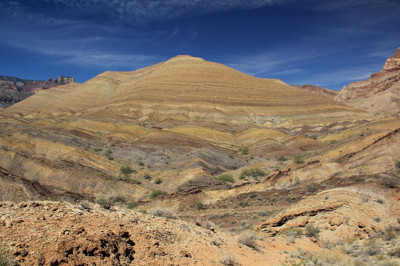
Photo by Laurie Crossey.
Rock Type
Tilted sedimentary and igneous rock layers
Environment
Rivers and shallow seas far from the active plate margin as the supercontinent Rodinia assembled (Unkar Group) and rifted apart (Chuar Group)
Age (Ma; mega annum = million years ago)
Meso- and Neoproterozoic Eras (Precambrian)729–1255
The rocks of the Grand Canyon Supergroup are primarily sedimentary strata, are divided into the lower Unkar Group and the upper Chuar Group, and range in age from 1,255 Ma to 729 Ma (Figures 23 and 24; Table 5). These rocks formed in fault-bounded continental rift basins.A slight angular unconformity separates the Unkar Group from the overlying Chuar Group.
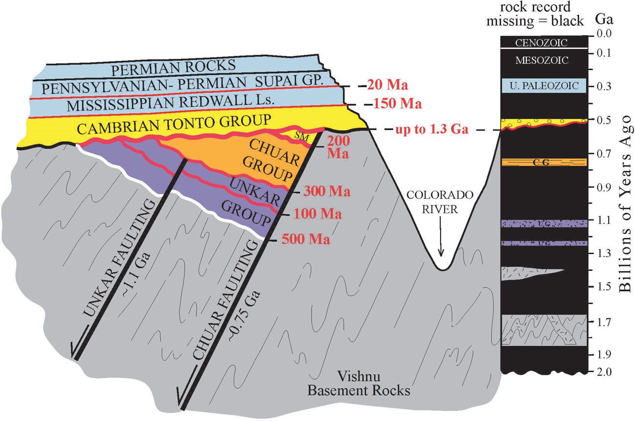
Figure 23. Rock and Time. Grand Canyon has one of the world’s most complete geologic records, yet more time is missing (black = time not recorded in the column on the right) than preserved. We assign approximate numeric ages to the time missing along the unconformities based on the age range of rocks directly above versus below these erosion surfaces. Note that the modern erosion surface on top of the Kaibab Formation has 270 million years missing. Diagram does not show all formations and unconformities in the Layered Paleozoic Rocks because of space considerations.
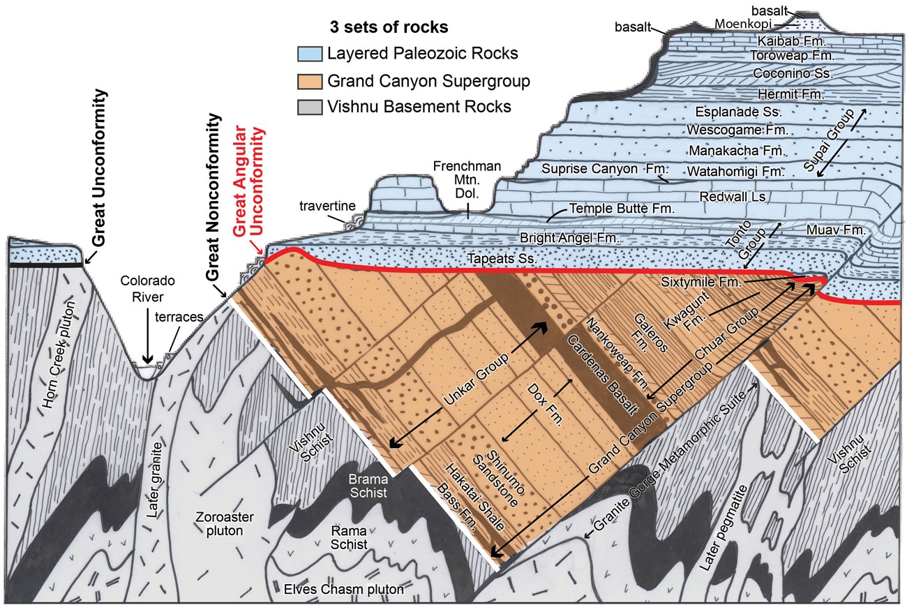
Figure 24. Stratigraphic column of rocks of the Grand Canyon region showing the three sets of rocks and major unconformities: Great Nonconformity (white line), Great Angular Unconformity (red line) and Great Unconformity (black line). Fm = Formation; Ss = Sandstone; Ls = Limestone.
| Group | Formation | Stratigraphic Age | Numeric Age (Ma) | Precision (Ma) | Duration (Ma) |
| Chuar Group | Kwagunt Formation Walcott Member | Neoproterozoic | 729 | ± 1 | 729–745 |
| Kwagunt Formation Awatubi Member | Neoproterozoic | 750 | ± 8 | 745–751 | |
| Kwagunt Formation Carbon Butte Member | Neoproterozoic | 753 | – | 751–755 | |
| Galeros Formation Duppa Member | Neoproterozoic | 755 | – | 755–757 | |
| Galeros Formation Carbon Canyon Member | Neoproterozoic | 757 | ± 7 | 757–760 | |
| Galeros Formation Jupiter Member | Neoproterozoic | 765 | – | 760–765 | |
| Galeros Formation Tanner Member | Neoproterozoic | 770 | – | 765–770 | |
| Nankoweap Formation | Neoproterozoic | 775 | – | 770–775 | |
| Unkar Group | Cardenas Basalt | Mesoproterozoic | 1,082 | ± 1.25 | 1,081–1,083 |
| Dox Formation | Mesoproterozoic | 1,120 | – | 1,105–1,140 | |
| Shinumo Sandstone | Mesoproterozoic | 1,130 | – | 1,140–1,150 | |
| Hakatai Shale | Mesoproterozoic | 1,230 | – | 1,230–1,245 | |
| Bass Formation | Mesoproterozoic | 1,255 | ± 2 | 1,245–1,250 | |
| Bass Formation Hotauta Conglomerate Member | Mesoproterozoic | 1,255 | – | 1,250–1,255 |
Table 5.
The Unkar Group (Figures 29 and 30) consists of sediments that were shed off mountains in the region now part of west Texas that formed during the assembly of the Rodinia supercontinent. The Unkar Group was deposited between 1,255 Ma and 1,082 Ma.

Figure 29. Units of the Unkar Group as seen from the South Rim at Lipan Point. The members of the Dox Formation are also labeled.
Photo by Laurie Crossey.
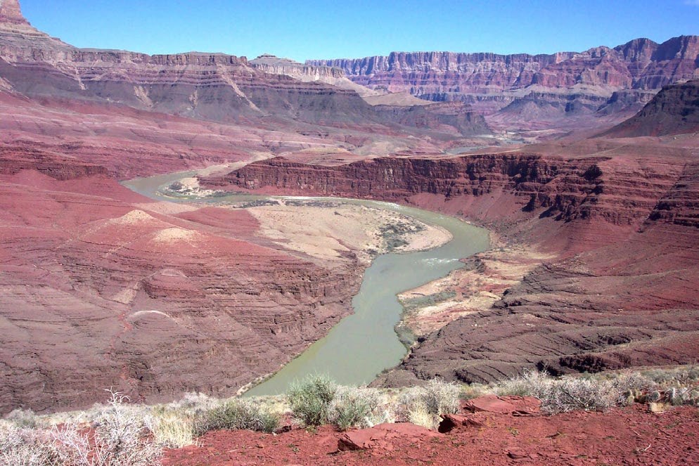
NPS photo.
Continental collisions taking place far to the south (in modern coordinates) formed the supercontinent Rodinia and squeezed southwestern North America. This compression caused NE-trending folds that formed basins flooded by shallow seas.
1,230–1,255
Interlayered with the carbonate and sandstone of the rest of the Bass Formation so it is the same age
Radiometric U-Pb zircon date is 1,255 ± 2 Ma from volcanic ash bed
Youngest zircons are 1,255–1,230 Ma
NW-SE compression from continental collisions to the south (present coordinates) caused the continent to rift along NW-trending basins that filled with sediments from rivers and floodplains. Finally, these basins were intruded by molten rock forming dikes and sills that fed eruptions of the Cardenas Basalt lava flows.
1,082–1,150
Youngest zircons indicate <1,150, but is greater than 1,082 Ma Cardenas
Youngest zircons indicate <1,130 but is greater than 1,082 Ma Cardenas
Radiometric U-Pb dating of dikes that fed the basalts gives 1082.18 ± 1.25 Ma
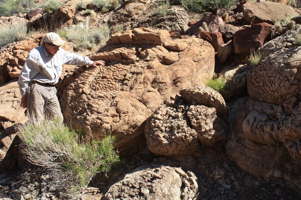
Photo by Laurie Crossey.
The Chuar Group is made up of mudstone with interbeds of sandstone and carbonate (Figure 14). It contains a rich diversity of single-celled organisms (Figure 31). Its fossils include the first heterotrophic predators (organisms that ate each other). Tectonically, the Chuar Group records the breakup and rifting of the Rodinia supercontinent and the formation of the proto-Pacific ocean. Chemically, the Chuar Group shows wild oscillations in ocean chemistry as the expanding biosphere was interacting with the atmosphere and hydrosphere during the interval leading to the Snowball Earth (717 to 635 million years ago, a time not recorded by Grand Canyon rocks).
The Chuar Group consists of three formation:
729–755
Age Range (Ma; mega annum = million years ago)
770–775
Tectonic and Depositional Environment
Sandstones that formed near the shore of an intracontinental seaway.
Age (Ma; mega annum = million years ago)
755–770
Tectonic and Depositional Environment
As the Chuar basin subsided, muds and limes were deposited in a seaway that intermittently dried out and reflooded.
|
Formation |
Stratigraphic Age |
Numeric Age (Ma) |
|
Galeros Formation Duppa Member |
Neoproterozoic |
755 |
|
Galeros Formation Carbon Canyon Member |
Neoproterozoic |
757 |
|
Galeros Formation Jupiter Member |
Neoproterozoic |
765 |
|
Galeros Formation Tanner Member |
Neoproterozoic |
770 |
Numeric ages for members were assigned by:
Tanner Member: Stratigraphic fit between Carbon Canyon Member and Nankoweap Formation
Juniper Member: Stratigraphic fit between Carbon Canyon Member and Nankoweap Formation
Carbon Canyon Member: Organic-rich carbonates give a date of 757 ± 7 Ma based on Re-Os radiometric date
Duppa Member: Stratigraphic fit between 751–757
Age (Ma; mega annum = million years ago)
729–755
Tectonic and Depositional Environment
As the supercontinent Rodinia broke up, rift basins were filled with sediments. The Chuar sediments were deposited in shallow inland seaways that extended to Death Valley, northern Utah, and beyond.
Members and Age
|
Formation |
Stratigraphic Age |
Numeric Age (Ma) |
|
Kwagunt Formation Walcott Member |
Neoproterozoic |
729 |
|
Kwagunt Formation Awatubi Member |
Neoproterozoic |
750 |
|
Kwagunt Formation Carbon Butte Member |
Neoproterozoic |
753 |
Numeric ages for members were assigned by:
Major revisions to the stratigraphy of the Grand Canyon Supergroup occurred in 2017 with the publication of new research on the age and stratigraphic relationships of units in the supergroup.
New zircon data has indicated that the Nankoweap Formation is younger than previously thought, with a maximum age of 775 Ma instead of the 900 Ma date previously assigned to it. As a result of the new date, as well as it having a similar depositional history to the units above it, the Nankoweap was incorporated into the Chuar Group.
The Sixtymile Formation was previously placed in the Grand Canyon Supergroup because of its flexure in the Chuar syncline. The previous age of 650 Ma based on the incorrect interpretation that it was related to sea level drawdown during glaciations of the Snowball Earth. The Sixtymile Formation was moved to Cambrian Tonto Group based on the age of the youngest detrital zircons that are as young as 530 Ma at the base of the section and 508 Ma at the top.
New age determinations have also refined the age of several formations within the Grand Canyon Supergroup (Table 7). Numeric ages for members in the Kwagunt and Galeros formations in the Chuar Group are given because geologists have studied each member extensively and treat them with the attention generally given to formations.
Direct ages have also been obtained by application of the rhenium-osmium radiogenic dating method on carbonates in the 757 Ma Carbon Canyon Member, and the 751 Ma Awatubi Member where nodules of iron-sulfide (marcasite) were dated (Table 5). Because the relative sequence of layers is so clear (Fig. 14), the durations of most Chuar members is estimated to be just 3–5 million years each (Table 5).
The formal names of several formations have also been changed to better reflect their composition.
To learn more about the age of Grand Canyon’s rocks, please see:
Karlstrom, K., L. Crossey, A. Mathis, and C. Bowman. 2021. Telling time at Grand Canyon National Park: 2020 update. Natural Resource Report NPS/GRCA/NRR—2021/2246. National Park Service, Fort Collins, Colorado. https://doi.org/10.36967/nrr-2285173. [IRMA Portal]
Babcock, R. S. 1990. Precambrian crystalline core, in S. S. Beus and M. Morales, editors. Grand Canyon geology, first edition. Oxford University Press, Oxford, United Kingdom.
Billingsley, G. H., and S. S. Beus. 1985. The Surprise Canyon Formation, an Upper Mississippian and Lower Pennsylvanian (?) rock unit in the Grand Canyon, Arizona. U.S. Geological Survey, Washington, D.C. Bulletin 1605: A27–A33.
Breed, W.J., and Ford, T.D., 1973, Chapter Two-and-a-half of Grand Canyon history, or the Sixty Mile Formation: Plateau, v. 46, no. 1, p. 12-18.
Cohen, K. M., S. C. Finney, P. L. Gibbard, and J.-X. Fan. 2013; updated in 2020. The ICS International Chronostratigraphic Chart. Episodes 36: 199–204. Available at https://stratigraphy.org/icschart/ChronostratChart2020-01.pdf (accessed 01 Jun 2020).
Dehler, C., G. Gehrels, S. Porter, M. Heizler, K. Karlstrom, G. Cox, L. Crossey, and M. Timmons. 2017. Synthesis of the 780–740 Ma Chuar, Uinta Mountain, and Pahrump (ChUMP) groups, western USA: Implications for Laurentia-wide cratonic marine basins. Geological Society of America Bulletin 129(5–6): 607–624. doi: 10.1130/B31532.1.
Francischini, H., S. G. Lucas, S. Voight, L. Marchetti, V. L. Santucci, C. L. Knight, J. R. Wood, P. Dentzien-Dias, and C. L. Schultz. 2019. On the presence of Ichniotherium in the Coconino Sandstone (Cisuralian) of the Grand Canyon and remarks on the occupation of deserts by non-amniote tetrapods. Paläontologische Zeitschrift online: 119.
Gehrels, G. E., R. Blakey, K. E. Karlstrom, J. M. Timmons, S. Kelley, B. Dickinson, and M. Pecha. 2011. Detrital zircon U-Pb geochronology of Paleozoic strata in the Grand Canyon, Arizona. Lithosphere 3: 183–200. doi: 10.1130/L121.1.
Hawkins, D. P., S. A. Bowring, B. R. Ilg, K. E. Karlstrom, and M. L. Williams. 1996. U-Pb geochronologic constraints on Proterozoic crustal evolution. Geological Society of America Bulletin 108: 1167–1181.
Hintze, L. F. and B. J. Kowallis. 2009. Geologic History of Utah. Brigham Young University Geology Studies Special Publication 9, Provo, Utah.
Holland, M. E., K. E. Karlstrom, G. Gehrels, O. P. Shufeldt, G. Begg, W. L. Griffin, and E. Belousova. 2018. The Paleoproterozoic Vishnu basin in southwestern Laurentia: implications for supercontinent reconstructions, crustal growth, and the origin of the Mojave province: Precambrian Research 308: 1–17.
Ilg, B. R., K. E. Karlstrom, D. Hawkins, and M. L. Williams. 1996. Tectonic evolution of Paleoproterozoic rocks in Grand Canyon, Insights into middle crustal processes. Geological Society of America Bulletin 108: 1149–1166.
Karlstrom, K. E., S. A. Bowring, C. M. Dehler, A. H. Knoll, S. Porter, Z. Sharp, D. Des Marais, A. Weil, J. W. Geissman, M. Elrick, M. J. Timmons, K. Keefe, and L. Crossey. 2000. Chuar Group of the Grand Canyon: Record of breakup of Rodinia, associated change in the global carbon cycle, and ecosystem expansion by 740 Ma. Geology 28: 619–622.
Karlstrom, K. E., and L. J. Crossey. 2019. The Grand Canyon Trail of Time companion: Geology essentials for your canyon adventure. Trail of Time Press, Albuquerque, New Mexico.
Karlstrom, K. E., J. Hagadorn, G. G. Gehrels, W. Mathews, M. Schmitz, L. Madronich, J. Mulder, M. Pecha, D. Geisler, and L. J. Crossey. 2018. U-Pb dating of Sixtymile and Tonto Group in Grand Canyon defines 505–500 Ma Sauk transgression. Nature Geoscience 11: 438–443.
Karlstrom, K. E., S. S. Harlan, M. L. Williams, J. McLelland, J. W. Geissman, and K. I. Ahall. 1999. Refining Rodinia: Geologic evidence for the Australia–Western U.S. connection for the Proterozoic. GSA Today 9(10): 1–7.
Karlstrom, K. E., B. R. Ilg, M. L. Williams, D. P. Hawkins, S. A. Bowring, and S. J. Seaman. 2003. Paleoproterozoic rocks of the Granite Gorges. Pages 9–38 in S. S. Beus and M. Morales, editors. Grand Canyon geology, second edition. Oxford University Press, Oxford, United Kingdom.
Karlstrom, K. E., M. T. Mohr, M. Schmitz, F. A. Sundberg, S. Rowland, J. Hagadorn, J. R. Foster, L. J. Crossey, C. Dehler, and R. Blakey. 2020. Redefining the Tonto Group of Grand Canyon and recalibrating the Cambrian timescale. Geology 48: 425–430. doi: 10.1130/G46755.1.
Karlstrom, K., S. Semken, L. Crossey, D. Perry, E. D. Gyllenhaal, J. Dodick, M. Williams, J. Hellmich-Bryan, R. Crow, N. Bueno Watts, and C. Ault. 2008. Informal geoscience education on a grand scale: The Trail of Time exhibition at Grand Canyon. Journal of Geoscience Education 56: 354–361.
Karlstrom, K. E., and J. M. Timmons. 2012. Many unconformities make one “Great Unconformity” in J. M. Timmons and K. E. Karlstrom, editors. Grand Canyon geology: 2 billion years of Earth history. Geological Society of America Special Paper 489, Boulder, Colorado.
Lillie, Robert J. 2005. Parks and plates: The geology of our national parks, monuments, and seashores. W. W. Norton, New York, New York.Mathis, A. 2006. Grand Canyon yardstick of geologic time: A guide to the canyon’s geologic history and origin. Grand Canyon Association, Grand Canyon, Arizona, USA.
Mathis, A. and C. Bowman. 2005a. What’s in a number?: Numeric ages for rocks exposed within Grand Canyon. Nature Notes XXI(1). Grand Canyon National Park, Arizona.
Mathis, A. and C. Bowman. 2005b. What’s in a number?: Numeric ages for rocks exposed within Grand Canyon. Part 2. Nature Notes, v. XXI(2). Grand Canyon National Park, Arizona.
Mathis, A. and C. Bowman 2006a. The grand age of rocks Part 1— Numeric ages for rocks exposed within Grand Canyon. Boatman’s Quarterly Review 19(1):27–29. Grand Canyon River Guides, Flagstaff, Arizona. Available at https://www.gcrg.org/bqr/pdfs/19-1.pdf (accessed 01 Jun 2020).
Mathis, A. and C. Bowman 2006b. The grand age of rocks Part 2—Grand Canyon’s three sets of rocks. Boatman’s Quarterly Review: Grand Canyon River Guides. 19(2):19–23. Grand Canyon River Guides, Flagstaff, Arizona. Available at https://www.gcrg.org/bqr/pdfs/19-2.pdf (accessed 01 Jun 2020).
Mathis, A. and C. Bowman 2006c. The grand age of rocks Part 3—Geologic dating techniques. Boatman’s Quarterly Review 19(4):19–23. Grand Canyon River Guides, Flagstaff, Arizona. Available at https://www.gcrg.org/bqr/pdfs/19-4.pdf (accessed 01 Jun 2020).
Mathis, A. and Bowman, C. 2007. Telling Time at Grand Canyon National Park. Park Science, 24(2): 78–83. Available at https://irma.nps.gov/Datastore/DownloadFile/615879 (accessed 07 May 2020).
McKee, Edwin D. 1931. Ancient landscapes of the Grand Canyon region. Northland Press, Flagstaff, Arizona.
McKee, Edwin D. 1969. Stratified rocks of the Grand Canyon. In The Colorado River Region and John Wesley Powell. USGS Professional Paper 669-B. Washington DC. Available at https://pubs.usgs.gov/pp/0669/report.pdf (accessed 11 May 2020).
McKee, E. D. 1975. The Supai Group — Subdivision and nomenclature. U.S. Geological Survey Bulletin 1395-J, Washington, D.C , Washington, D.C.McKee, E. D., and C. E. Resser. 1945. Cambrian history of the Grand Canyon region. Carnegie Institution of Washington Publication 563.
Mohr, M.T., M.D. Schmitz, N.L. Swanson-Hysell, K.E. Karlstrom; F.A. Macdonald, M.E. Holland, Y. Zhang, N. Anderson. In review. High-Precision U-Pb geochronology links magmatism in the SW Laurentia Large Igneous Province and Midcontinent Rift.
Mulder, J. A., K. E. Karlstrom, K. Fletcher, M. T. Heizler, J. M. Timmons, L. J. Crossey, G. E. Gehrels, and M. Pecha. 2017. The syn-orogenic sedimentary record of the Grenville Orogeny in southwest Laurentia. Precambrian Research 294: 33–52.
National Park Service. 2017. Foundation Statement. Grand Canyon National Park. Grand Canyon, Arizona.
Perry, D. L. 2012. What makes learning fun? Principles for the design of Intrinsically motivating museum exhibits. AltaMira Press, Lanham, Maryland.
Powell, J. W. 1875. Exploration of the Colorado River of the West and its tributaries. Explored in 1869, 1870, 1871, and 1872, under the direction of the Secretary of the Smithsonian Institution. U.S. Government Printing Office, Washington, D.C., USA.
Rooney, A. D., J. Austermann, E. F. Smith, Y. Li, D. Selby, C. M. Dehler, M. D. Schmitz, K. E. Karlstrom, and F. A. Macdonald. 2018. Coupled Re-Os and U-Pb geochronology of the Tonian Chuar Group, Grand Canyon. Geological Society of America Bulletin 130(7–8): 1085–1098.
Santucci, V. L., and J. S. Tweet, editors. 2020. Grand Canyon National Park: Centennial paleontological resource inventory (non-sensitive version). Natural Resource Report NPS/GRCA/NRR—2020/2103. National Park Service, Fort Collins, Colorado.
Schuchert, Charles. 1918. The Cambrian of the Grand Canyon of Arizona. American Journal of Science (Series 4) 45: 368.
Shufeldt, O. P., K. E. Karlstrom, G. E. Gehrels, and K. Howard. 2010. Archean detrital zircons in the Proterozoic Vishnu Schist of the Grand Canyon, Arizona: Implications for crustal architecture and Nuna reconstructions. Geology 38: 1099–1102.
Spamer, Earle E. 1989. The development of geological studies in the Grand Canyon. Tryonia. Miscellaneous Publications of the Department of Malacology. The Academy of Sciences of Philadelphia No. 17. Philadelphia, Pennsylvania.
Timmons, J. M., and K. E. Karlstrom, editors. 2012. Grand Canyon geology: 2 billion years of Earth history. Geological Society of America Special Paper 489. Boulder, Colorado.
Timmons, J. M., K. E. Karlstrom, M. T. Heizler, S. A. Bowring, G. E. Gehrels, and L. J. Crossey. 2005. Tectonic inferences from the ca. 1255–1100 Ma Unkar Group and Nankoweap Formation, Grand Canyon: Intracratonic deformation and basin formation during protracted Grenville orogenesis. Geological Society of America Bulletin 117(11–12): 1573–1595.
Whitmeyer, S., and K. E. Karlstrom. 2007. Tectonic model for the Proterozoic growth of North America.Geosphere 3(4): 220–259.
Absolute age: a numeric age in years. Numeric age is the preferred term.
Accuracy: measure of how close a numeric date is to the rock’s real age.
Angular unconformity: a type of unconformity or a gap in the rock record where horizontal sedimentary layers (above) were deposited on tilted layers (below). At Grand Canyon, horizontal layers of the Layered Paleozoic Rocks lie on top of the tilted rocks of the Grand Canyon Supergroup.
Basalt: a dark, fine-grained volcanic (extrusive igneous) rock with low silica (SiO2) content.
Biochron: length of time represented by a fossil biozone.
Carbonate: sedimentary rock such as limestone or dolostone largely composed of minerals containing carbonate (CO3-2) ions.
Contact: boundary between two bodies of rock or strata.
Daughter isotope: the product of decay of a radioactive parent isotope.
Detrital: pertaining to grains eroded from a rock that were transported and redeposited in another.
Dike: a wall-like (planar) igneous intrusion that cuts across pre-existing layering.
Diabase: a dark igneous rock similar in composition to basalt but with coarser (larger) grain size.
Disconformity: a type of unconformity or gap in the rock record between two sedimentary layers caused by erosion or nondeposition where the layers are parallel to one another.
Dolomite: the mineral calcium magnesium carbonate CaMg(CO3)2 that usually forms when magnesium-rich water alters calcium carbonate (CaCO3).
Dolostone: a rock predominantly made of dolomite.
Eon: longest subdivision of geologic time in the Geologic Timescale; for example, the Proterozoic Eon.
Era: second-longest subdivision of geologic time below eon in the Geologic Timescale; for example, the Paleozoic Era.
Epoch: fourth-longest subdivision of geologic time, shorter than a period and longer than a stage in the Geologic Timescale; for example, the Pleistocene Epoch.
Faunal succession: the change in fossil assemblages through time which has a specific, reliable order.
Foliation: tectonic layering in metamorphic rocks caused by parallel alignment of minerals due to compression.
Formation: the fundamental unit in stratigraphy and geologic mapping that consists of a set of strata with distinctive rock characteristics. Formations may consist of a single rock type (e.g., Tapeats Sandstone or Redwall Limestone), or a mixture of rock types (e.g. Hermit Formation, which includes sandstone, mudstone, and shale).
Fossil: evidence of life in a geologic context usually consisting of the remains or traces of ancient life.
Fossil biozone: stratigraphic unit defined by a distinctive assemblage of fossils.
Ga: giga annum: billion years; in this paper, our usage implies billion years before present (or ago) when used for numeric ages.
Gneiss: a high-grade metamorphic rock with strong foliation and light and dark bands of minerals.
Granite: a high silica (SiO2) pink to white intrusive igneous rock composed mainly of feldspar and quartz.
Granodiorite: a gray intrusive igneous rock composed of feldspar, quartz, biotite, and hornblende with less silica (SiO2) than granite.
Group: a sequence of two or more related formations, with a stratigraphic rank higher than formation; for example, the Chuar Group is made up of the Nankoweap, Galeros, and Kwagunt formations.
Igneous rock: a rock that solidified from molten material (magma or lava), either within the Earth (as an intrusive or plutonic rock) or after eruption onto the Earth’s surface (as an extrusive or volcanic rock).
Inclusion: a fragment of an older rock within a younger rock.
Index fossil: a fossil or assemblage of fossils that is diagnostic of a particular time in Earth history.
Intrusion: an igneous rock body that crystallized underground. Intrusions may have any size or shape; large ones are known as plutons, thin ones parallel to layering are known as sills, and thin ones that cut across layering are called dikes.
Isotope: one of the forms of a chemical element (with the same atomic number) that contains a different number of neutrons.
Lateral continuity: a geologic principle that sedimentary rocks extend laterally, and that if they are now separated due to erosion, they were once laterally continuous; for example, the Kaibab Formation on the South Rim is laterally continuous with the Kaibab Formation on the North Rim.
Lava: molten rock erupted onto the Earth’s surface.
Ma: mega annum: million years; in this paper, our usage implies million years before present (or ago) when used for numeric ages.
Magma: molten or partially molten rock material formed within the Earth.
Member: a subdivision of a formation, usually on the basis of a different rock type or fossil content; for example, the Hotauta Conglomerate is a member of the Bass Formation.
Metamorphic rock: a rock formed by recrystallization under intense heat and/or pressure, generally in the deep crust.
Monadnock: a bedrock island that sticks above the general erosion level.
Nonconformity: an unconformity or gap in the rock record where sedimentary layers directly overlie older and eroded igneous or metamorphic rocks.
Numeric age: age of a rock in years (sometimes called absolute age).
Numeric age determination: measurement of the age of a rock in years, often through the use of radiometricdating techniques.
Orogeny: mountain building event, usually in a collisional tectonic environment.
Parent isotope: the radioactive isotope that decays to a daughter isotope.
Pegmatite: a type of intrusive igneous rock usually of granitic composition with large crystal size.
Period: third-longest subdivision of geologic time shorter than an era and longer than an epoch in the Geologic Timescale; for example, the Permian Period.
Plate tectonics: theory that describes the Earth’s outer shell as being composed of rigid plates that move relative to each other causing earthquakes, volcanism, and mountain building at their boundaries.
Pluton: large intrusion of magma that solidified beneath the Earth’s surface.
Precambrian: the period of time before the Cambrian Period that includes the Proterozoic, Archean, and Hadean eons and represents approximately 88% of geologic time.
Precision: measure of the analytical uncertainty or reproducibility of an age determination.
Proterozoic: geologic eon dominated by single-celled life extending from 2,500 to 541 million years ago; divided into the Paleoproterozoic (1,600–2,500 Ma), Mesoproterozoic (1,000–1,600 Ma), and Neoproterozoic (541–1,000 Ma) eras.
Radioactive decay: the process by which the nuclei of an unstable (radioactive) isotope lose energy (or decay) by spontaneous changes in their composition which occurs at a known rate for each isotope (expressed as a half life); for example, the parent uranium (238U) isotope decays to the daughter lead (206Pb) isotope with a half life of 4.5 billion years.
Radiometric dating: age determination method that uses the decay rate of radioactive isotopes and compares the ratio of parent and daughter isotopes within a mineral or rock to calculate when the rock or mineral formed.
Regression: geologic process that occurs when the sea level drops relative to the land level; for example, by sea level fall and/or uplift of the land, causing the withdrawal of a seaway from a land area.
Relative time: the chronological ordering of a series of events.
Rift basin: a basin formed by stretching (extension) of the Earth’s crust. Rift basins are linear, fault-bounded basins that can become filled with sediments and/or volcanic rocks.
Rodinia: a Neoproterozoic supercontinent that was assembled about 1.0 Ga (during Unkar Group time) and rifted about 750 Ma (during Chuar Group time).
Sedimentary rock: a rock composed of sediments such as fragments of pre-existing rock (such as sand grains), fossils, and/or chemical precipitates such as calcium carbonate (CaCO3).
Schist: a metamorphic rock with platy minerals such as micas that have a strong layering known as foliation or schistosity.
Silica: silicon dioxide (SiO2), a common chemical “building block” of most major rock-forming minerals, either alone (i.e., as quartz) or in combination with other elements (in clays, feldspars, micas, etc.).
Sill: a sheet-like igneous intrusion that is parallel to pre-existing layering.
Snowball Earth: a hypothesis that the Earth’s surface became completely or mostly frozen between 717 and 635 million years ago.
Stage: a short subdivision of geologic time in the Geologic Timescale often corresponding to the duration of a fossil assemblage.
Stratigraphic age: the era, period, epoch, or stage a rock is assigned to based on its fossil biozones or numeric age.
Stratigraphy: the study of layered rocks (strata), which usually consist of sedimentary rock layers, but may also include lava flows and other layered deposits.
Stromatolite: a fossil form constructed of alternating layers (mats) of microbes (algal or bacterial) and finegrained sediment.
Subduction zone: a plate boundary where two plates converge and one sinks (subducts) beneath the other.
Supergroup: a sequence of related groups, with a higher stratigraphic rank than group; for example, the Grand Canyon Supergroup consists of the Unkar and Chuar groups.
Superposition: principle of geology that the oldest layer in a stratigraphic sequence is at the bottom, and the layers get progressively younger upwards.
Tectonics: large-scale processes of rock deformation that determine the structure of Earth’s crust and mantle.
Trace fossil: a sign or evidence of past life, commonly consisting of fossil trackways or burrows.
Transgression: a movement of the seaway across a land area, flooding that land area because of a relative sea level rise and/or land subsidence.
Travertine: calcium carbonate (CaCO3) precipitated by a spring; most travertine deposits also contain some silica.
Unconformity: a rock contact across which there is a time gap in the rock record formed by periods of erosion and/or nondeposition.
Volcanic ash: small particles of rock, minerals, and volcanic glass expelled from a volcano during explosive eruptions. Volcanic ash may be deposited great distances (even hundreds of miles or kilometers) from the volcano in especially large eruptions.
Yavapai orogeny: mountain building period that occurred approximately 1,700 million years ago when the Yavapai volcanic island arc collided with proto-North America.
Zircon: a silicate mineral (ZrSiO4) that often forms in granite and other igneous rocks and incorporates uranium atoms, making it useful for radiometric dating.
Grand Canyon National Park (GRCA), Arizona—[GRCA Geodiversity Atlas] [GRCA Park Home] [GRCA npshistory.org]
Part of a series of articles titled Telling Time at Grand Canyon National Park.
Previous: Vishnu Basement Rocks
Next: Layered Paleozoic Rocks
Last updated: January 30, 2024