Last updated: November 22, 2022
Contact Us
Article
Grand Encampment Exhibit Audio Description

NPS Exhibit
Another Setback Exhibit Audio Description
-
Grand Encampment Another Setback Exhibit Audio Description
Listen to the audio description Another Setback - Mormon Pioneer National Historic exhibit.
- Credit / Author:
- NPS
- Date created:
- 11/22/2022
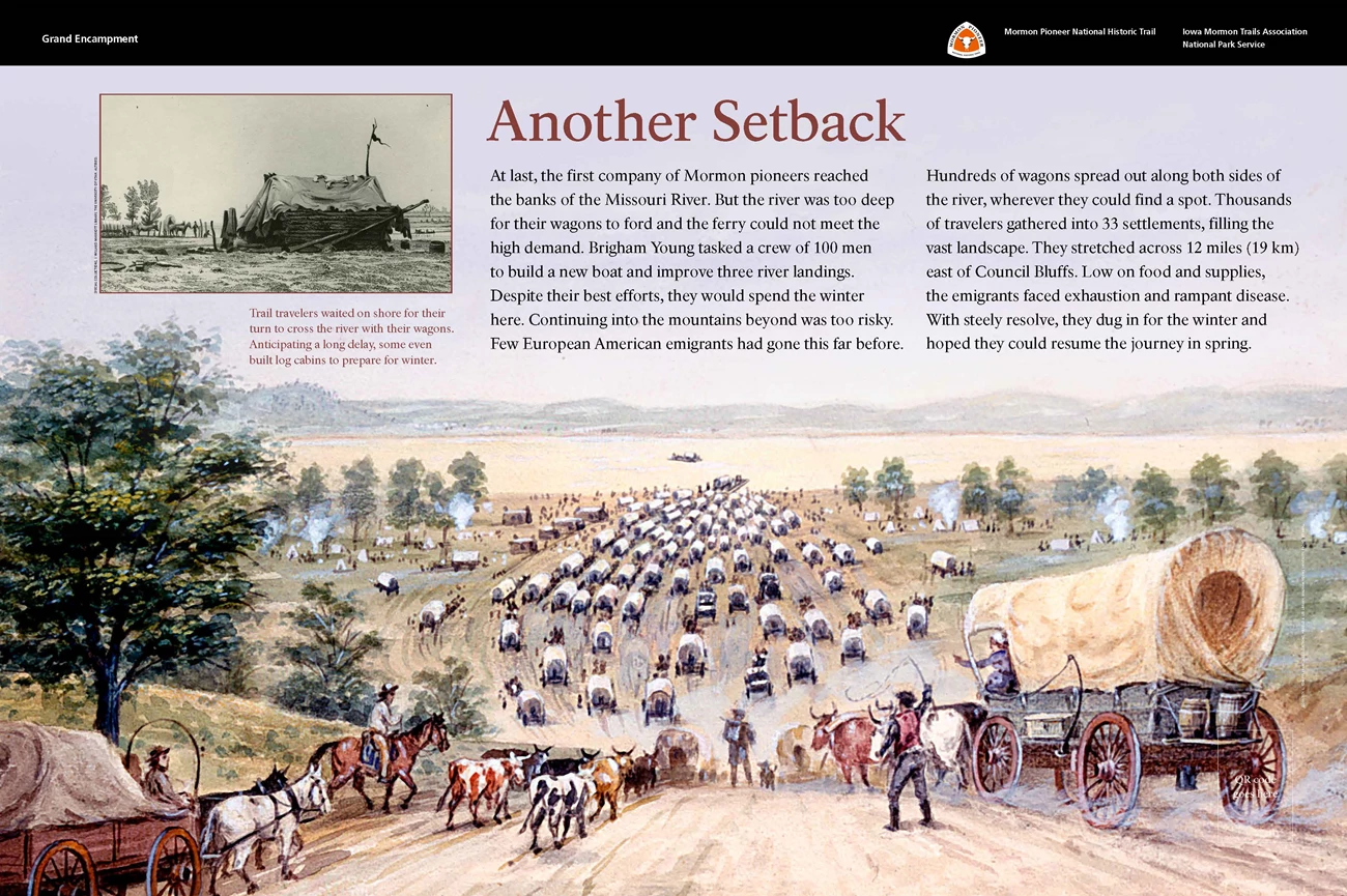
Slanted Wayside Panel: Another Setback In front of you, is a slanted exhibit panel 3 feet wide 2 feet tall, and about 3 feet off the ground. You are on a paved sidewalk that extends to your left and right, and loops around the entire Iowa School for the Deaf campus. There are scattered deciduous trees on both sides of the sidewalk. Beyond the panel, there is a main road, about 60 feet, or 18 meters, away. To your left, about 60 feet, or 18 meters, away is a smaller road that leads to the buildings in the Iowa School for the Deaf campus. This smaller road has a parallel sidewalk. There is a traffic light at the intersection of the main road and the smaller road.There is a black banner across the top on the panel. Left side text reads Grand Encampment. Right side of the panel has the white, orange, and black triangular logo for the Mormon Pioneer National Historic Trail.
Below the banner, in the middle of the panel, is dark red and black text on a light gray background:
Title: Another Setback. Main Text: At last, the first company of Mormon pioneers reached the banks of the Missouri River. But the river was too deep for their wagons to ford and the ferry could not meet the high demand. Brigham Young tasked a crew of 100 men to build a new boat and improve 3 river landings. Despite their best efforts, they would spend the winter here. Continuing into the mountains beyond was too risky. Few European American emigrants had gone this far before.
Hundreds of wagons spread out along both sides of the river, wherever they could find a spot. Thousands of travelers gathered into 33 settlements, filling the vast landscape. They stretched across 12 miles, or 19 kilometers, east of Council Bluffs. Low on food and supplies, the emigrants faced exhaustion and rampant disease. With steely resolve, they dug in for the winter and hoped they could resume the journey in spring.
End of Text
To the left of the text, is a grayscale photograph of a log cabin covered with a loose cloth. The cabin is set in a flat, relatively barren landscape, with scattered items including barrels and large rings. To the left of the cabin, are 2 covered wagons, several animals, and a few men tending to either the wagons or the animals. To the right, in the background, is a river. 2 wagons cross the river on a ferry. On the far side of the river, are 2 more wagons.
Text below illustration: Trail travelers waited on shore to cross the river with their wagons. Anticipating a long delay, some even built log cabins to prepare for winter.
End of Text
A colorful painting fills the rest of the panel. Across the bottom of the panel, is a wide dirt road. The road descends into the background, toward the top of the panel, and levels out. In the foreground, are wagons, teams of oxen, and men on horseback leading livestock. The level part of the road is filled with about 100 covered wagons led by livestock. Gray streaks of dust behind the wagons suggest they are moving quickly. To the left and right of the road, is a grass-covered landscape, with small dots that represent people, stopped wagons, canvas tents, and billowing white smoke from various campfires. There are also tall, green, leafy trees.
The road ends at the river, which spans the panel from left to right and has a light orange, muddy hue. 1 ferry with a covered wagon is leaving shore. Another ferry with a covered wagon is in the middle of the river. There are rolling grayish green hills on the far side of the river. In the bottom right corner of the panel, is a QR code that you can scan with a mobile device to explore more about this wayside, including audio description. [End of Message]

