Last updated: May 10, 2021
Article
Sixty Years in the Life of Denali's Muldrow Glacier (1952 to 2010)
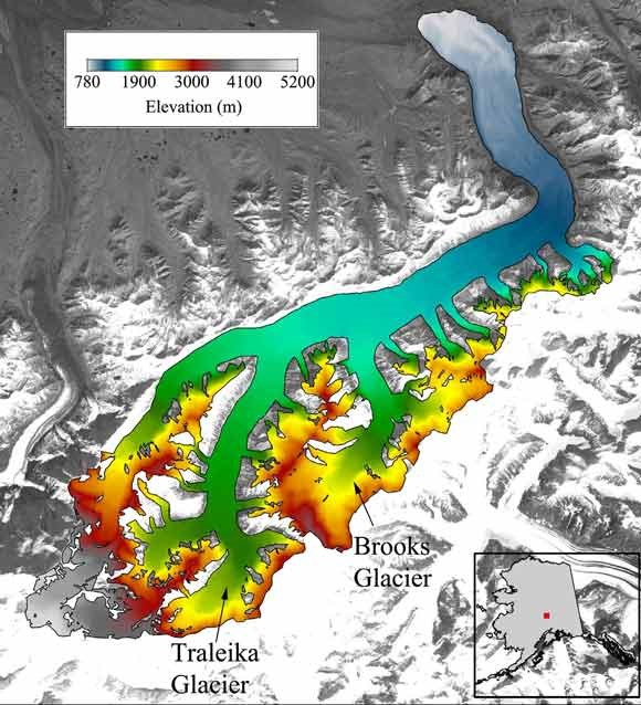
Muldrow Glacier is a long, surging glacier that descends thousands of feet on the northeastern slopes of Denali, in Denali National Park. Muldrow last surged during the winter of 1956-‐1957, with ice moving up to 6.6 km over a period of a few months. Observations by climbers and debris patterns suggest that the surge initiated on the Traleika Glacier, the largest tributary of the Muldrow. Our investigation looked at the likelihood of another surge in the near future.

Harrison (1964) hypothesized that the previous surge of Muldrow occurred between 1906 and 1912, based on observations by climbers and explorers in those years. Harrison (1964) adds that debris patterns on Muldrow Glacier suggest that Muldrow had surged at least three times in the 200 years prior to the 1956-‐57 surge, further suggesting that Muldrow Glacier had maintained a roughly 50 year surge cycle for over two centuries.
However, it is unclear whether Muldrow Glacier will surge again under current climate conditions. It is possible that changes in climate have interrupted Muldrow’s surge cycle similar to other Alaska glaciers (e.g., Heinrichs et al., 1996).
To investigate the likelihood that Muldrow will surge again, we utilize both DEMs and airborne laser altimetry to trace the elevation changes of Muldrow Glacier from 1952, four years before the surge, to 2010.
Methods
We use three DEMs:
(1) the National Elevation Dataset (NED) 2-arcsecond DEM, based on surveys in 1952;
(2) the Washburn DEM, based on aerial photogrammetry and ground-‐based surveys supervised by B. Washburn in 1976; and
(3) the Aero-Metric DEM based on a LiDAR survey completed by Aero-‐Metric, Inc. in 2006.
We calibrated all three DEMs with off-ice locations north of the Muldrow terminus.
We use two centerline elevation profiles from 2008 and 2010 acquired using airborne laser altimetry acquired as part of the UAF laser altimetry project

1952 to 2006
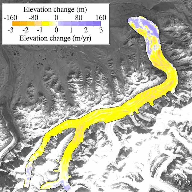
If the Muldrow Glacier was retaining its historical surge period of ~50 years, we would expect similar elevations in 2006, 49 years post-‐surge, to those just prior to the surge in 1952 with a near-‐zero mass balance. Instead, the surface of Muldrow is ~30 to 40 m below its surface in 1952 and the mass balance and mass change are both negative (-0.52 +0.22/-0.24 m/yr w.e. and -0.06 + 0.02/-0.03 Gt/yr).
1952 to 1976
This period is dominated by the 1956-‐57 surge that caused significant drawdown above the hinge line (~1250 m) and buildup below. The elevation changes of the surge are muted by the unavoidable inclusion of the first 19 years of post-‐surge recovery. The mass balance of the measured region is slightly negative (-‐0.2 +0.2/-‐0.6 m/yr w.e.) and the mass change is negligible.
1976 to 2006
Recovery from the surge continued to dominate during this portion of the quiescent period. There was slight build-up of ice above the hinge line, but significant wastage below the hinge line. The mass balance and mass change of the measured region are both negaEve (-‐0.74 +0.44/-‐0.42 m/yr w.e. and -‐0.08 +/-‐0.05 Gt/yr). The included portions of the upper Muldrow and Traleika did show positive elevation change.
2008 to 2010
The overall mass balance and mass change of Muldrow Glacier are negative over this two year period, which may suggest Muldrow will be unable to achieve the ice mass and driving stress necessary to trigger another surge. However, both the Traleika Glacier and upper Muldrow (>1700 m) show positive mass balance.
Conclusions
If Muldrow Glacier had maintained its historical surge period, it should have surged in the mid 2000s. The lack of a surge suggests that the mass balance of Muldrow Glacier and its tributaries has decreased since the last surge cycle.
However, since past Muldrow surges have originated on the Traleika, some form of a surge—either the entire Muldrow or some portion of it— may still occur. Driving stress calculations (not shown here) suggest that the Traleika needs to add approximately 25 m of ice to match 1952 driving stress.
Hence, the Traleika and some portion of the Muldrow may surge again if the Traleika maintains a positive mass balance.
