Last updated: March 11, 2025
Article
The Columbia Sensitive Resource Zone: Balancing Conservation and Visitor Experience at Cuyahoga Valley National Park
"The National Park Service preserves unimpaired the natural and cultural resources and values of the National Park System for the enjoyment, education, and inspiration of this and future generations." — from the National Park Service mission statement
A growing challenge for the National Park Service (NPS) in some parks is finding a sustainable balance between resource conservation and recreation. A sensitive area in Cuyahoga Valley National Park provides an example of this kind of challenge.
Shared Stewardship
You can help by...
The boundaries of Cuyahoga Valley National Park encompass a total of 33,000 acres. Of that acreage, nearly a third is owned and managed by two metropolitan park districts, Cleveland Metroparks and Summit Metro Parks. Although there are some differences between the rules and management strategies of the NPS and these other park systems, stewardship of the natural and cultural landscape is important to all.
But the park systems can't do this on their own. Visitors like you also share in the responsibility for stewardship of Cuyahoga Valley.
Sensitive Resources and Social Trails
Cuyahoga Valley’s planning efforts include a recently completed Community Access Plan. The planning process designated certain “sensitive resource zones” in the park. The designation calls for the highest level of protection of the park’s most sensitive natural resources. In these zones, park staff strive to preserve and protect the ecological integrity of mature forests, high-quality wetlands, rare plant communities, unique geologic features, and habitats such as seeps and springs.
NPS
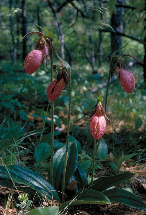
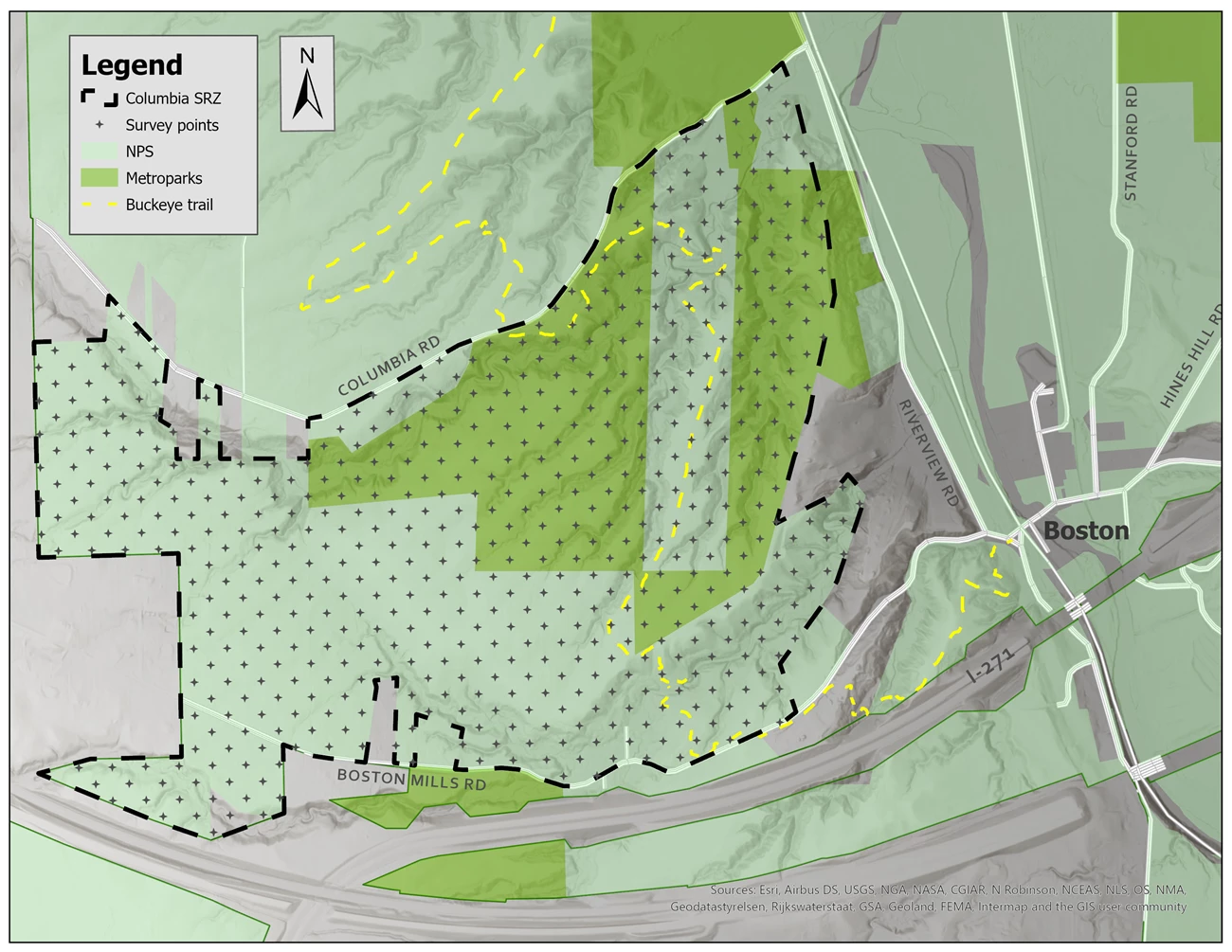
One of the sensitive zones identified by the park is the area between Boston Mills and Columbia roads, referred to as the Columbia Sensitive Resource Zone. This area has been shown to contain a lush streamside plant community with sensitive species such as pink lady's slipper and dwarf crested iris. Blue Hen Falls, one of the most popular sites in the park, also falls within this zone.

NPS
Map of the Columbia Sensitive Resource Zone (SRZ); at top left, the legend lists the Columbia SRZ border, survey points, NPS, Metroparks, and the Buckeye Trail, with corresponding colors and patterns for each, and a north arrow points straight up, parallel to the sides of the map; the Columbia SRZ covers most of the area between Columbia Road to the north, Riverview Road to the east, and Boston Mills Road to the south; the western boundary is irregular and no road is shown on that side; within the zone, a little more than half of the land is shaded light green to show NPS ownership; a few irregularly shaped parcels are shaded a darker green to show Metroparks ownership; cutting through the eastern side of the zone is a yellow dashed line representing the Buckeye Trail, which winds off out of the zone to the north and the southeast as well; throughout the zone, a regular pattern of hundreds of small plus signs indicate survey points; outside the southeast corner of the zone, the village of Boston is labeled and various roads are shown in white, extending off the map in different directions.

Courtesy Summit Metro Parks
The park’s visitation metrics show a noticeable increase to the area in recent years, beginning around 2016. The higher volume of pedestrian traffic to the site has had an impact on natural resources and on the overall visitor experience. With increased pedestrian traffic, park staff have also noted the development of a visitor-created "social trail" that leaves the designated trail near Blue Hen Falls and cuts down toward another waterfall known as Buttermilk Falls. Since such social trails develop unofficially, they are not designed sustainably like other park trails. Resource degradation can become easily apparent when such sites experience a high volume of visitation.
Increased traffic along the half-mile social trail to Buttermilk Falls has resulted in visible soil compaction, trampling of vegetation, soil erosion, and potentially even the spread of invasive plant species. Large sections of the streamside plant community are now devoid of vegetation and rare plants have not been re-located.
Gathering Data to Inform Our Actions
The NPS funded a "focused condition assessment" in 2021 for an intensive inventory of natural and cultural resources in the Columbia Sensitive Resource Zone. Biologists from Summit Metro Parks (SMP) and NPS Inventory & Monitoring staff worked together to perform natural resource investigations. They used a modelling technique developed by SMP to identify areas where recreation and development could be preferred, and others where it should be avoided to protect sensitive resources.Survey work sought to describe plant communities and to locate sensitive habitat types and rare species. They also inventoried other natural resources including wetlands, streams, bats, snakes, salamanders, and fish. Finally, they considered the land use history for the area, which can play a major role both in the current state of the land and its future potential.
When it's published, the final report from the focused condition assessment will be used to guide park managers in planning for this area.

© Joe Prekop, Jr.
Be Part of the Solution
The future state of Blue Hen Falls, Buttermilk Falls, and the entire Columbia Sensitive Resource Zone will depend on all of us. Park managers will need the help of visitors to protect sensitive resources. How can we find a sustainable balance between preserving these resources “unimpaired” and providing for the enjoyment of the public?
Here are some ways you can help:
- Stay on marked trails and respect park closures.
- Avoid following visitor-created “social trails.”
- Tread lightly and avoid sensitive areas. When hiking off-trail for any reason, be mindful of trampling vegetation, soil erosion or compaction, and invasive species – check for seeds on your shoes and clothes.
Thank you for participating in shared stewardship.
Tags
- cuyahoga valley national park
- ohio
- midwest
- heartland network
- htln
- biodiversity
- plants
- wildflowers
- sensitive plant communities
- resource management
- natural resources
- natural resource management
- park science
- conservation
- connected conservation
- collaborative conservation
- landscape stewardship
- conservation partnerships
- inventory and monitoring
- leave no trace
- nrca
- natural resource condition assessment
