Last updated: January 24, 2022
Article
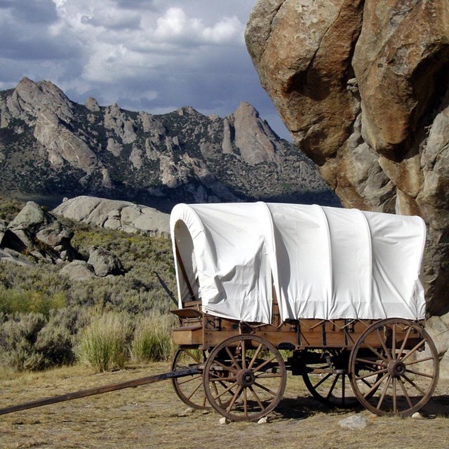
A Hike to Roller Pass on the California Trail
Take a five-mile roundtrip hike along the Pacific Crest National Scenic Trail near Truckee, Cal., to explore one of the California Trail’s more difficult passages through the Sierra Nevada!

Photo/NPS
“As we came up to it the appearances was exactly like marching up some immense wall built directly across our path, so perpendicular is the dividing ridge.” – Elisha Perkins, 1849
If you’ve ever encountered a steep obstacle—a cliff or a seemingly endless set of stairs—you may know the queasy feeling experienced by immigrants approaching the forbidding eastern escarpment of the Sierra Nevada range. Four-hundred miles long, sixty miles wide, and with jagged peaks over 14,000 feet high, the Sierra Nevada posed the most difficult challenge on the California Trail. One way through, and the first to be successfully attempted by covered wagons back in 1844, was the Truckee Route.

Photo/NPS
Today’s travelers can comfortably cruise the eastern section of the Truckee Route by heading west on Interstate 80 from Reno, Nev., toward Donner Pass in California. Travelers 180 years ago, though, had no paved lanes, road cuts, or carefully engineered bridges to ease the bumps and jumps of the trail, and no powerful engines to do the work. Ox-drawn covered wagons had to lurch across boulder-choked streams, clamber through mazes of gullies and canyons, and heave up mountainsides, all under muscle-power alone. The climb from Truckee Lake to the crest of the Sierra Nevada—“steep as the roof of a house,” as one immigrant put it—could be called the first of the worst of these challenges. A modern geologist compares that ascent to “an ant trying to climb out of an ice-cream scoop.”
“When they got to the mountains with their wearied and wabbliny teams, and looked up toward the high and steep summit which they had to cross…their hearts almost gave way.” – Elam Brown, immigration of 1846
“Roller Pass” was one of three places where travelers on the Truckee Route could climb out of the “scoop.” Here, immigrants faced a 400-foot climb up a 30-degree slope littered with loose boulders. To surmount it, they unhitched five to twelve yoke (teams) of oxen and drove them to the summit. There they hooked up the animals to the end of a long chain that ran to the bottom of the slope, where the other end was attached to a waiting wagon. At the lip of the summit the chain passed over a log, which acted as a bearing or “roller” to ease the strain of the haul. Men stationed themselves at each wheel of the wagon to help push. With this setup, the immigrants hauled up their wagons one by one. Sometimes the chain broke and a wagon—with no human occupants—careened back to the foot of the slope and crashed to splinters. Those that made it up and over without accident now faced a frightening descent down the west face of the mountain.
“We had traveled all kinds of bad roads, but we began to believe the worst was yet to come, and in this we certainly were not mistaken.” –Heinreich Lienhard, 1846 immigration.

Photo/NPS
Today, visitors can hike along the Pacific Crest National Scenic Trail to Roller Pass (about 5 miles round-trip with an elevation gain of 800 feet) and view the chutes cut by the towing process. Hikers who start by 8 a.m. will find the trail shady most of the way, and those hiking in early summer will see many kinds of wildflowers. The first half-mile of the hike is steep and rocky, so recreate responsibly by having appropriate footwear, clothing, and first aid equipment. All visitors should carry water with them on the hike.

Photo/NPS
")
Photo/NPS
Directions
This hike is in California. Driving in either direction on I-80, take Exit 174 (Soda Springs) and continue east on Donner Pass Rd/Old Hwy 40. In 3.9 miles, turn right into the parking area next to the Summit Haus, a brown building with a sloping, barn-style roof. Park near the large white (historic) snowshed. Kiosks with historical information about the area are located to the left of the shed.
From the kiosks, walk east down the road about 200 yards to the kiosk and trailhead. Two trails begin there: take the one directly ahead onto the Pacific Crest National Scenic Trail. In about a mile, you can choose to continue straight on the main path or turn left onto the scenic Judah Pass Loop Trail, which rejoins the main trail ahead. A short distance ahead, the main trail diagonally crosses a two-track road—be careful not to turn onto the road. At the pass, footpaths spread out in various directions; the Roller Pass ascent is to the left, and trail swale crossing from it is clearly visible. Look for a brown T-rail marker among the trees as you walk toward the viewpoint at the rim.
July Wildflowers
While Roller Pass offers a chance to step into the shoes of immigrants travelling the California Trail, it is also rich with natural beauty. When National Trails staff visited Roller Pass in July, wildflowers were in bloom along the trail. Enjoy this virtual wildflower tour or visit the trail in the summer to see them in person.
Visit our keyboard shortcuts docs for details
- Duration:
- 55.067 seconds
Take a virtual hike to Roller Pass on the California National Historic Trail and see some of the beautiful wildflowers that bloom during summer.