


Diving in Amistad National Recreation Area
 Diver explores the opening of the long-lost Goodenough Springs
Amistad Lake began impounding water in 1968-its waters deriving from three rivers: the Pecos, Devils, and Rio Grande. Along the border between Texas and Mexico, just north and west of Del Rio, the The Devils River, and Rio Grande merge and the lake they form behind the dam is fed farther east by the Devil's River. Though dammed into a lake, the rivers retain their shape, creating a branching body of water with a lengthy shoreline.
Amistad has literally had its ups and downs. In August, 1998, it was 58.64 feet lower than noral conservation level at 1,117l, leaving huge pieces of the surrounding landscape whitened by dried algae. Paved roads, long ago flooded by the lake, had to be cleared of decades of lake-bottom silt so boaters could drive their rigs down to the edge of the lake. In May, 2013 Amistad had its historical low at 1055.87' (-61.13ft) below conservation level at 1,117.
BASICS
Location: West Texas on border with Mexico
Elevation: Lake Level at conservation pool 1,117ft
Skill level: Intermediate-advanced
Access: Boat or shore
Dive support: There are currently no open dive shops. The closest is 3 hrs away in San Antonio or San Angelo.
Best time of year: November-April; algae May-October
Visibility: Nov thru Apr 15, 20ft; May thruOct -10ft
Highlights: Submerged boats, buildings, old dams, fish and clear water.
Concerns: Fishing lines, hooks under water; bring knife Emergencies: Dial 911
Medical Facilities: Val Verde Regional Medical Center, Del Rio, TX 830-775-8566
Nearest hyperbaric chamber: Fort Duncan Regional Medical Center, Eagle Pass, TX 830-773-5321
Dive Site Map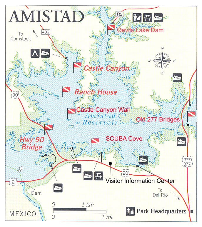
Dive Overview
Diving Amistad is a relatively easy proposition; it's getting there that's the challenge. Del Rio is not located at the crossroads of the nation, but if you make it to this part of Texas, you'll find plenty to do. Most people park and dive at the SCUBA cove and various pullouts. Of the sites we list below, all except the Ranch House and Castle Canyon can be reached from the shore. If you have a boat, the rest of the park is at your subaqueous disposal. Boat launches are spread around the lake, and you can rent boats at the Diablo East Marina.
Water visibility is best during cool months (November to April) when it peaks at 25 to 30 feet. From May to October, increased algae growth reduces visibility to less than 10 feet. Surface water temperatures range from mid-50s in winter to mid-80s in the summer. Thermoclines occur at 30-40 feet during the winter and deeper during the summer.
A knife is essential to diving Amistad. Monofilament fishing line is everywhere and a cheap diver's knife could make entanglement just a nuisance instead of a tragedy. In certain areas of the lake, such as around the Ranch House, carry wire cutters. You will probably never need them, but the first time you are caught in a trot line or strand of barbed wire, any prior inconvenience in carrying them will be quickly forgotten. Check in and register at the Visitor Information Center and pick up a brochure to learn about any recent changes in diving regulations or accident management protocols.You will also find useful information online at www.nps.gov/amis. Many of the park employees are divers themselves and you will find them helpful and knowledgeable.
Dive Sites
DIABLO EAST VIEWPOINT ROAD - CLIFFS AND SCUBA COVE
The dive cove is buoyed to keep boats out. There are two boat wrecks here to explore. A dock with exit ladder is provided. Due to this area being regularly used for SCUBA instruction, spear guns are prohibited.
CASTLE CANYON
A number of protected coves in this canyon make convenient spots to beach a boat and dive. There is a rock wall dive on the north side of the island between buoys CC-A and CC-B. This dive will give you plenty of opportunities to interact with fresh water fish.
HIGHWAY 90 BRIDGE
This is generally a good dive area throughout the year. Visibility is some of the best in the lake, especially at whichever end of the bridge is in the lee of the wind, for example, the northwest end of the bridge during northwesterly winds.
GOODENOUGH SPRINGS
When Lake Amistad was formed, Goodenough Springs - the third largest in Texas, was submerged under its waters. Visiting divers and park rangers were convinced it was still flowing somewhere in the bottom of the lake, but finding it was a challenge. In 1994, members of the Submerged Resources Center located, with the assistance of the park staff, the entrance to Goodenough Springs and made the first dive a short distance into the conduit. The lake water could boast only three or four feet visibility and the temperature in late May was not much above 60 degrees F. How startling, then, to find crystal-clear water in the 70s at 125 feet. This dive should only be attempted by experienced, certified cave divers with specific equipment and training. Recreational divers are not allowed to dive this site. Should an accident occur in Goodenough Springs, the park does not have the resources to affect a rescue or recovery.
RANCH HOUSE
Northeast of Ward's Point in Evans Creek, it is marked by a buoy. When visibility is good, this is a fascinating dive into recent history. It is a single-story house from the thirties, complete with windows and fireplaces but missing a roof so you can see it all without getting into an overhead environment. Although there are a few small and uninteresting structures where you can end up with a ceiling above your head, there is no reason at all to go inside them, even if you are trained in cave diving.
DEVILS RIVER DAM
Located just below the Rough Canyon Campground, the historic Devils River Dam is now open to divers. Constructed in 1928, the dam was submerged in 1969 after the completion of Amistad Dam. The top of the old power house is approximately at 55 foot depth when the lake is at conservation level. It is highly recommended that divers not enter the power house as black out conditions and entrapment dangers exists.
OLD 277 BRIDGES
Submerged in 1969, the old Highway 277 bridges offer a look at historic bridge construction and some great fish habitat. It can be accessed from boat or shore using either the 277 North or 277 South park areas.
DIVING RULES AND REGULATIONS
Diver-down flag must be displayed while divers are in the water except in the scuba cove.
Diving prohibited in the marinas, protected swim areas, near the Amistad Dam or near the two submerged dams in the Devil's River, and in the Rio Grande below the dam from the stilling basin up to and including the Weir Dam.
All archaeological artifacts, historical items, and natural features are protected by federal law and must be left undisturbed.
Divers must have a Texas fishing license to spear in U.S. waters and a Mexican license for the Mexico side of the lake.
No game fish such as bass, catfish and walleye may be speared, only rough fish such as carp, buffalo, drum, suckers, shad, goldfish, Tilapia (African Perch) and gar.
Boats must stay clear of all protected buoy areas and at least 100 feet from diver-down flags.
Last Updated: September 5, 2013


