| |
 | |
 | |
 | |
 | |
 | |
 | |
 | |
 | |
 | |
 | |
 | |
 | |
 | |
 | |
 | |
 |
 |
Yosemite Roads and Bridges
Yosemite National Park, California
 |
This brochure was produced by the Historic American Engineering Record (HAER), a division of the National Park Service, U.S. Department of the Interior. The Yosemite Roads and Bridges Recording Project, conducted in 1991, was cosponsored by Yosemite National Park. Michael Finley, Superintendent; Kevin Cann, Chief of Maintenance and Engineering:; The NPS Roads and Bridges program, John Gingles, Manager; and the Historic American Buildings Survey/Historic American Engineering Record (HABS/HAER), Robert J. Kapsch, Chief. The fieldwork measured drawings, histories, photography and this brochure were completed under the direction of Eric N. DeLony, Chief and Principal Architect, HAER. The recording team consisted of Todd A. Croteau, field supervisor: architectural tehnicians Dione DeMartelaere, David R. Fleming and Marie-Claude LeSauteur (US/ICOMOS); and photographer Brian C. Grogan. Web Edition by RD Payne. This brochure was written by project historian, Richard H. Quin, designed by the HAER team, and edited by Lola Bennett. |
|
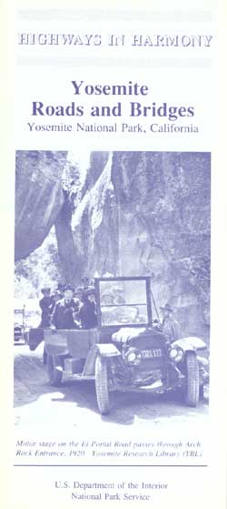
Motor stage on the El Portal Road passes through Arch Rock Entrance, 1920. Yosemite Research Library (YRL) |
| begin tour | back | home |
| Introduction | Acadia | Blue Ridge Parkway | Colonial Parkway | Generals Highway | George Washington Memorial Parkway | Great Smoky Mountains | Mount Rainier | Rock Creek and Potomac Parkway | Shenandoah's Skyline Drive | Southwest Circle Tour | Vicksburg | Yellowstone | Yosemite | Discover History |