![]()
Cover Page
MENU
![]() Glacier
Glacier
|
Glimpses of Our National Parks
THE GLACIER NATIONAL PARK MONTANA (United States Section of the Waterton-Glacier International Peace Park) Special Characteristics: Rugged, Colorful Mountains of Distinctive Shape; Enormous Twisting Glacier-Scooped Valleys; High Precipices; 200 Alpine Lakes of Great Beauty; 60 Small Glaciers |
 XI
XI

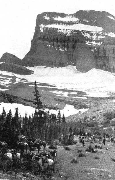
 Camping party at foot of Grinnell Glacier—Glacier National Park |
THE Glacier National Park is so named because in the hollow of its rugged mountain tops lie more than 60 small glaciers, the remainders of ancient monsters which once covered all but the highest mountain peaks. It is a richly colored land of gigantic cirques, ruggedly modeled mountains, enormous twisting glacier-scooped valleys, precipices thousands of feet high, innumerable rushing streams, and hundreds of lakes of unusual romantic beauty. Though all the national parks have these general features in addition to the ones which differentiate each from the other, the Glacier National Park possesses them in unusual abundance and especially happy combination. In fact, the almost sensational massing of these scenic features is one of the elements of its marked individuality.
Its geological history is identical with that of the Canadian Rockies, but the region lies in a much older rock formation. There is no other scenic area in the world to compare it with except the far less colorful, much snowier, and much less accessible Canadian Rockies. In richness of beauty it stands alone.
A ROMANCE OF GEOLOGY
How nature made this remarkable area far back in the dim ages long before man is a stirring story.
In an age of the earth's making millions of years ago, before the Continent of North America had emerged in its present outlines from the sea, the shales which now loom so loftily in Glacier National Park were deposited as sediments in the waters. Over these muds thick beds of ooze solidified into limestones, and over the limestones more sediments deposited and turned to shales. It is these very strata, now hardened into rocks, that streak so picturesquely the sides of Glacier precipices thousands of feet above us. The story of their elevation from deep-sea bottoms to these giddy heights is a romantic chapter in the making of America.
The earth has assumed its present proportions through the settling of its masses, and this settling caused great internal pressures.
Often the earth's skin has broken as the skin of the squeezed orange breaks; and that is what must have happened where Glacier National Park now lies. The bottom of the sea, under the enormous pressure against its sides and from below, gradually rose and became dry land.
Then the land at this point, probably because it was pushed hard by the contracting land masses on both sides of it, rose in long, irregular wavelike masses, forming mountains. Then, when the rock could no longer stand the awful strain, it cracked, and one edge was thrust upward and over the other edge and settled into its present position.
The edge that was thrust over the other was thousands of feet thick. From the overthrust place, erosional agents, principally glaciers, carved the mountains, precipices, and gorges that are the distinguishing beauty of the Glacier National Park today.
But mark this: When the western edge of the earth's cracked skin overthrust the eastern edge, it brought its bottom surface over and on top of the eastern edge; and this bottom surface was the oldest sedimentary rock known, the very same strata of mud and limestone ooze which were deposited in the sea millions of years ago. And mark this also, that the erosion of the years following has washed away all the deposits of the later geological ages that lay on the top of these strata, so that this ancient rock here lies fully exposed in all the glory of its greens and reds and grays, and all the fantastic carvings of the countless years. Of course, the pressures which made the earth's skin rise and buckle and break made the Rocky Mountains, which at this point carry the Continental Divide. It is the same process which has made most of the mountain systems throughout the world, though there are few overthrusts so great as Glacier's.
The fantastic carving of Glacier National Park was principally the work of glaciers in the soft rock. Three times did great ice sheets, wooed south by falling temperatures, descend upon this region to dig the mighty cirques and scoop the immense valleys, and, between these visitations and since the last, frost and rain have chipped and washed and polished. Eating backward into the rocks from both sides, the glaciers nearly met a thousand times, leaving a land of enormous hollows separated by gigantic walls twisting and winding in all directions.
By these processes during uncountable years nature has created and decorated this marvelously beautiful region for our enjoyment today.
SCENES OF EXQUISITE BEAUTY
To picture to yourselves this region, imagine a chain of very lofty mountains, twisting about like a worm, spotted everywhere with snow fields and bearing glistening glaciers in 60 or more hollows. Imagine these mountains crumbled and broken on their east sides into precipices, sometimes 3,000 or 4,000 feet deep, and flanked everywhere by castellated walls, lesser peaks, and tumbled mountain masses of smaller size in whose hollows lie gemlike lakes.
Down from the Continental Divide descend 19 principal valleys, 7 on the east side and 12 on the west. Of course, there are very many smaller valleys tributary to each of these larger valleys. Through these valleys run the rivers from the glaciers far up on the mountains.
PURCHASED FROM THE INDIANS
Many of these valleys are not yet thoroughly known. It is possible that some of them have never been even entered unless by Indians. The great Blackfeet Indian Reservation, one of the many tracts of land set apart for the Indians still remaining in this country, adjoins the Glacier National Park on the east. Northward the park adjoins the Waterton Lakes Park in Canada.
There are 200 known lakes, many of them stocked with fish. There may be small ones in the wilder parts which white men have not yet seen.
This park was not seen by white men until 1846, when Hugh Monroe visited and named St. Mary Lake. In 1853 a Government engineer, exploring for a route to the Pacific Ocean, ascended one of the creeks by mistake and returned when he found that no railroad could be built there. The next explorers were engineers who went in to establish the Canadian boundary line in 1861.
In 1890 copper was found and there was a rush of prospectors. In 1895 Congress bought the land east of the Continental Divide from the Blackfeet Indians, but there was not enough copper to pay for the mining. After that few persons except big-game hunters went there till 1910, when it was made a national park.
GOING-TO-THE-SUN HIGHWAY
The Going-to-the-Sun Highway, opened to travel throughout its length in 1934, is a magnificent transmountain road, the only highway crossing the Continental Divide within the park. By means of this spectacular roadway, visitors unable to take to the trails afoot or on horseback may penetrate into the mountains, going over the divide by way of famous Logan Pass.
It is the plan of the National Park Service that no other road shall be constructed across the park, which always will remain primarily a wilderness area.
INTERNATIONAL PEACE PARK
The Waterton-Glacier International Peace Park was established in 1932 by Presidential proclamation, as authorized by the Congress of the United States and the Canadian Parliament.
At the dedication exercises in June of that year, the following message from the President of the United States was read:
The dedication of the Waterton-Glacier International Peace Park is a further gesture of the good will that has so long blessed our relations with our Canadian neighbors and I am gratified by the hope and the faith that it will forever be an appropriate symbol of permanent peace and friendship.
In the administration of these areas each component part of the Peace Park retains its nationality and individuality. The Chief Mountain International Highway connects the two sections.
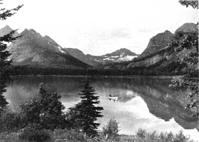
Red Eagle Lake—Glacier National Park
A fishing camp on this lake has no telephone. Mail
and newspaper delivery is indefinite.
It is an ideal vacation spot for the city-wearied.
 Top
Top
Last Modified: Fri, Sep 1 2000 07:08:48 pm PDT
http://www.cr.nps.gov/history/online_books/glimpses1/glimpses11.htm
![]()