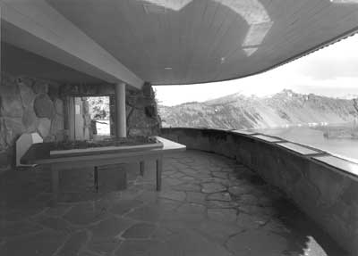

Parapet of the Sinnott Memorial.
|
|
Other Designed Features along Rim
Drive
A series of contracts let for grading,
surfacing, and paving were the most visible and costly parts of road
construction, but the NPS also took the lead in designing and building
trails, structures, and signs on Rim Drive. The latter group did not
require contracts or the need for BPR oversight and could be funded from
park accounts for projects (generally through hiring temporary employees
from these accounts, a method called "day labor") or through allotments
from work relief programs like the CCC. In each case, these designed
features were intended to meld with the contracted items as a part of
the circulation system called Rim Drive.
Trails
With only a few notable exceptions, most of
the foot trails built during the 1930s were intended to provide park
visitors with distinctly different views of Crater Lake from points not
reached by road. Trails allowed relatively easy access to a couple of
observation stations located along the western portion of Rim Drive,
while also giving visitors the opportunity to reach viewpoints such as
Mount Scott and Sentinel Point on the opposite side of the lake. Like
roads, they were built to specified standards that required (at least in
several instances) reconstructing earlier work on prominent features
like Garfield Peak or the Watchman. Much like his BPR colleagues, the
NPS resident engineer took the lead in locating trails, though final
approval of the route along with measures to protect vegetation came
through the lead landscape architect on site.
NPS resident engineer William E. Robertson
located a new trail linking the western end of Rim Village with
Discovery Point during the summer of 1932. This occurred once Merriam
and Wallace W. Atwood selected a site for an observation station, one
serving as the end of the footpath from Rim Village and a viewpoint that
required only a short walk from the nearby parking area on Rim Drive.
The Discovery Point Trail thus consisted of two segments, with the
longest having easy grades lasting for nearly a mile along the rim
before it met the large parking area at Station 55. From there the
trail made a short climb to the observation station at Discovery Point.
Crews built the trail in roughly three weeks in 1932, while Robertson
noted that he consulted Sager both before and during
construction.
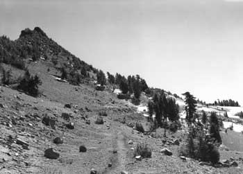
Trail following the old Rim Road below Hillman Peak.
|
Work on reconstructing the trail to the top of
Watchman also took place in 1932, starting from a point on the old Rim
Road that was situated above the new location for Rim Drive. This path
utilized portions of a rough trail made the previous summer to transport
materials for constructing the lookout and trailside museum, but with
better curvature and the addition of features like hand-placed retaining
walls and stone slabs for use as benches. The completed trail started
at the Watchman Overlook on Rim Drive and incorporated a piece of the
old Rim Road to a point where the path built by day labor brought park
staff and visitors to the summit. As with other popular trails where
dust was perceived as a problem, crews oiled the finished
surface.
A trail planned for connecting the parking
area at the Diamond Lake Junction with the viewpoint selected by Merriam
as the fourth observation station along Rim Drive did not materialize.
This probably stemmed from a decision made in 1934 to transfer funds
earmarked for development of three observation stations to instead help
finance repairs at the Sinnott Memorial. Without money to build masonry
guardrail and install a viewfinder at the observation station, there
seemed to be little need for a short trail from the junction to what
became known as Merriam Point, or a longer path to Llao Rock.
None of the remaining observation stations
beyond the Diamond Lake Junction featured trails. CCC enrollees
improved a path linking Sentinel Rock with the parking overlook at
substation 7-B in 1940, once the steps forming a trailhead were
completed through the surfacing contract. The CCC also extended a rough
"service road" part way up Mount Scott by building a horse trail that
reached the summit, which provided a better way of packing supplies to a
lookout located more than 2 miles away from Rim Drive. Visitor use as a
foot trail came as a secondary consideration, at least initially, so the
connection between trailhead and parking area remained weak.
Building foot trails became even less of a
priority once Rim Drive proceeded past Kerr Notch toward Park
Headquarters. Nothing more than social trails resulted at Sun Notch,
for example, despite of the careful study urged by an art professor
commissioned by Merriam to visit the park in 1932. In a similar vein,
Lange suggested extending a trail begun by the CCC near Vidae Falls in
1934 to Garfield Peak, or making a loop with an overlook so that
visitors could view the falls from above. Neither idea came to fruition,
though CCC enrollees built 1 new mile of trail to the top of Crater Peak
in 1933. Visitors traveling by foot or horseback on a fire road that
commenced where Rim Drive ran near Tututni Pass could thus reach the
summit of the prominent cinder cone that can be seen from various
viewpoints around the park. The trail through the Castle Crest
Wildflower Garden near Park Headquarters originated in 1929, though not
in reference to any future location of Rim Drive. A new parking area
intended to serve as the trailhead, however, came about as part of the
grading contract for 7-E2 in 1938. This development corresponded with
an effort led by the permanent park naturalist to reconstruct the trail
that summer.
Buildings
The NPS actively encouraged visitors to see
the Sinnott Memorial "as soon as possible" upon arriving in the park
because it helped them locate places of interest. Although situated in
Rim Village, "Observation Station No. 1" functioned as the main
orientation point prior to participating in a naturalist-led Rim Caravan
or taking a self-guided excursion on Rim Drive. In this respect, the
official park brochure for 1938 described the parapet as featuring
high-powered field glasses
"http://www.nps.gov.trained on the important features, helping
the visitor to understand the geological history of the lake and to
appreciate the relationship between the scenic and scientific. Displays
in the exhibit room, maintained in connection with the observation
station, further aid the visitor to appreciate the beauties of the park
and to interpret the moods of Crater Lake."
Built in 1930, the Sinnott Memorial's design
borrowed heavily from the slightly larger Yavapai Station erected on the
south rim of the Grand Canyon in 1927. Merriam was the main force
behind both buildings and saw to it that each incorporated an open porch
or parapet along with an enclosed display room or museum. Sager drew
the plans for the Sinnott Memorial, but Merriam expressed the underlying
purpose of the building as
"http://www.nps.gov.a window through which it is planned to
show the visitor things of major interest at the Lake. The active use
of the structure is strictly that of looking out and the museum aspect
should be reduced to a minimum, using only such materials as are helpful
in development of the window idea."
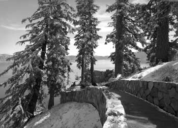
Victor Rock Trail to the Sinnott Memorial.
|
Although operational with the installation of
parapet exhibits in 1931, Merriam and park officials did not consider
the Sinnott Memorial completed until August 9, 1938. That morning an
exhibition aimed at helping visitors appreciate the aesthetic values of
Crater Lake opened in its museum room. The featured photographs,
paintings, and lighted transparencies were intended to induce visitors
to see various aspects of the beautiful landscape for themselves.
Merriam and his associates hoped that a "new phase" of educational work
at Crater Lake might thus begin, one where the interpretation of scenic
and scientific values at the Sinnott Memorial might inspire visitors as
they explored the park on their own.
Apparent success with reaching visitors at the
Yavapai Station prompted NPS Chief Naturalist Ansel Hall to suggest in
early 1930 that a fire lookout planned for the Watchman be enlarged to
accommodate an "educational lookout station or branch museum" on the
lower floor. Albright and Merriam received copies of Hall's letter to
Solinsky, and by March landscape architect Charles E. Peterson had
prepared a sketch for the building that included an elevated lookout
with a "trailside museum" adjoining it but at ground level next to a
"terrace" on the lakeside. After making a more definite study of the
building's location, Sager sent Hall a revised sketch by Lange in June
1931 incorporating all three elements. An allotment of $5,000 and the
final drawings prepared by Lange allowed laborers to complete most of
the building that summer. Work at the site continued in 1932, at which
time workmen built a masonry parapet wall around the point in front of
the building along with a bituminous walk. Hall installed field glasses
for the use of visitors to reinforce dual purpose of the
structure.
Assistant Superintendent and Chief Park
Naturalist Donald Libbey described plans for exhibits and the mounting
of range finders at each corner of the parapet prior to official opening
of the Watchman Observation Station in 1933, but his transfer that year
put installation of those interpretive devices on indefinite hold. The
NPS, however, continued to promote the building as an observation
station throughout the 1930s by offering a shortened version of the full
Rim Caravan that ran from Rim Village to the Watchman Overlook and
culminated with a hike to the lookout. The trip was so popular that it
became a daily feature of the naturalist program, relegating the full
Rim Caravan to the status of a special offering held just once a
week.
Visitors using the north entrance eventually
obtained their first view of Crater Lake at the Diamond Lake Junction.
The ranger station located there became known as the "North House" to
employees upon its construction in 1930. The initial design called for
exterior walls made of logs, but Sager drew the final plans to specify
the use of stone masonry in line with the precedent established at Rim
Village. The North House contained public restrooms, made possible by
piping water from a spring located near the Devil's Backbone, with an
office situated between them. In being slightly recessed into a gentle
slope back from the rim, the structure provided an attractive seasonal
residence that could also double as a visitor facility. Nevertheless,
the park's master plan started calling for its removal in 1939, since
improvement of the North Entrance Road (Route 8) in the interim allowed
for fee booth and associated quarters to be located next to the park
boundary.
Funds for building a "checking kiosk" near
the North House became available in the fall of 1933, but work did not
begin until the following summer. Robertson commented that frequent
storms led to periodic delays during the project, which was finally
completed over the summer of 1936. Until that time rangers collecting
park entrance fees at the road junction enjoyed no protection from the
elements because the North House had been located some 80' removed from
Rim Drive. Collecting fees remained difficult, however, because the
volume of traffic that resulted from opening the Willamette Highway in
1940 led to longer lines and congestion at the road junction. As a
result, the NPS placed a portable station near the actual north entrance
in July 1941 that Superintendent Leavitt described as greatly improving
fee collection. Despite the advantages of being on the rim to provide
visitor information, moving the checking operation spelled a quick end
to the kiosk's effective life.
A development seen as complementary to the
Diamond Lake Junction was briefly considered for Kerr Notch near the end
of 1936, though not referenced in the site plan by Lange for a parking
overlook. Envisioned for the junction of Rim Drive and the East
Entrance Road, a ranger station similar in size and appearance to the
North House would take the place of a log structure built in 1917 near
the park boundary some 7 miles distant. Crews razed the latter
structure in 1938, but the new ranger station at Kerr Notch did not
materialize even though the building could have used the same water
system that allowed use of a drinking fountain at the parking
overlook.
Signs
Customized signage for Rim Drive evolved from
a CCC project begun in 1936 at Park Headquarters that aimed to replace
various types of metal signs posted throughout the park. Enrollees
produced hand-carved wood signs of varying sizes with raised letters
painted chrome orange (for visibility at night) against a dark brown
background, based on Lange's drawings of entrance, directional, and
building signs. Their production and placement greatly accelerated over
the summer of 1938 after establishing an outdoor workshop at the CCC
camp near Annie Spring. Lange reported that 200 signs had been completed
by November, including some that identified parking areas and points of
interest on Rim Drive. Through photographs in his season-ending report,
he attempted to show how this type of sign possessed good visibility, if
properly placed, for conveying mileage and direction on Rim Drive.
These examples included signs mounted in a triangular configuration at
road junctions and others slotted into bollards.
East Entrance motif.
|
CCC enrollees produced more signs at Camp
Oregon Caves over the following winter and began installing them upon
returning to Crater Lake for the 1939 season. They reestablished a
workshop at the park that summer for a crew of fifteen men to carve,
assemble, and then place eighty signs. Lange provided "field sketch
details" as drawings for the crew to follow as he had the previous year,
but the signs completed that year varied somewhat more in size and shape
because of emphasis on the individualization of signs for points of
interest located along Rim Drive. Although he originally expected to
complete the project by October, the shift away from standardization may
have accounted for why the crew did not finish installation of the
remaining signs until 1940.
The sign project's apparent success stood in
sharp contrast to the lack of orientation markers or literature
describing each of the observation stations, ideas once advanced by
Merriam and embraced to some degree by the naturalists. At one point
Assistant Superintendent and Chief Park Naturalist Donald Libbey had
plans drawn to install markers similar to one on top of Pilot Butte in
Bend, but he transferred before the NPS could fund the project. Lange's
recommendation in 1935 for a "binocular instrument" at each of the
observation stations quickly dropped off the list of prospective
projects, as did the suggestion from Merriam about placing inconspicuous
holders for interpretive literature targeted specifically at the
stations and substations. The latter probably resulted when no one came
forward to implement the recommendation by Merriam that experts produce
literature for each of these stations, even after Howel Williams began
his classic study of the park's geology in 1936 and actively continued
his fieldwork through 1939.
|

