.gif)
A Survey of the Recreational Resources of the Colorado River Basin
MENU
Recreational Benefits of Reservoirs
![]() The Grand Canyon
The Grand Canyon
Canyon Lands of Southeastern Utah
Conservation of Recreational Resources
|
A Survey of the Recreational Resources of the Colorado River Basin
|

|
Chapter VII:
THE GRAND CANYON (continued)
EFFECT OF PROPOSED PROJECTS ON THE GRAND
CANYON
The projects proposed for the control and use of the Colorado River would completely change the natural conditions and character of the river through the Grand Canyon. In place of a thundering, heavily silt-laden river, it would be harnessed by dams into a series of quiet mill ponds, except through Grand Canyon National Park where it would be diverted under the plateau through which it has for millions of years been grinding its own way. The silt and debris would be dropped behind upstream dams. The river through the Grand Canyon without its grinding agents would no longer be the Colorado known to thousands of visitors who go to the bottom of the canyon each season. It would be a clear stream.
In place of great fluctuations in volume of flow between the spring months when the snow is melting on the Rockies, the Uintas, and the White Mountains and the winter months when the plateaus are dry and the mountains frozen, the flow would be regulated to meet the demands of the power plants. Between Marble Gorge Dam and Kanab Creek, roughly the area covered by Grand Canyon National Park, the flow would be regulated to a constant 1,000 second feet.
|
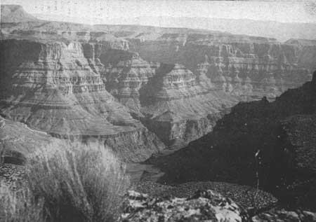
| Figure 70.—The Grande Canyon above Bridge Canyon—the high rim of Grand Canyon north of Diamond Creek forms the skyline. |
|
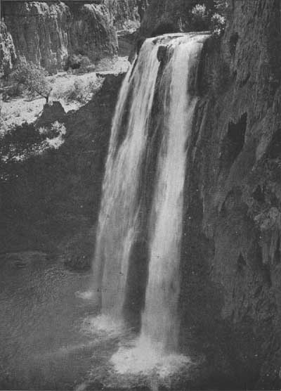
| Figure 71.—Havasu Falls—one of the four falls of Havasu Creek. |
With the series of dams proposed, silt and debris now carried by the Colorado River and deposited in Lake Mead would be drastically reduced. Navigation in the canyon section of Lake Mead, practically impossible at the present time because of silt conditions, would be stabilized, making it possible to travel with ordinary types of boats from Pierce Ferry to just below the Bridge Canyon Dam.
Bridge Canyon Dam and Reservoir.—The impounding of water behind Bridge Canyon Dam to an elevation of 1,876 feet probably would conceal few geological features that are unique or of special importance as documents of geological history. Any impoundment more than a few feet higher than that elevation, however, would back water beyond the upper reaches of the inner canyon to which it would otherwise largely be confined, and create a conspicuous, insistent intrusion into the broader part of the canyon visible from the rim. There would result an artificial reservoir replacing the natural river in some of the most spectacular and characteristic views of the canyon obtainable. The greatest losses, insofar as geological features are concerned, would be in the area of volcanic activity at and westward from Toroweap Valley. Several features illustrating the early stages of canyon cutting and of local volcanism would be inundated. Also covered would be the remnants of lavas that flowed down the river channel and, in two places, the sediments formed in ancient lakes or reservoirs behind natural lava dams. A detailed report on many of these features was made by Edwin D. McKee and Edward J. Schenk to the Director, National Park Service, in December 1941. The report is entitled "Lava Dams in Grand Canyon." The following statement appears in the report: "The spectacle of lavas that have cascaded down the steep canyon walls, and [of] cinder cones perched on the sides and brink of the chasm usually makes a profound impression on the layman, while to the geologist the problems presented are intriguing."
Toroweap Valley slopes gently toward the canyon rim and ends with a sheer cliff almost 3,000 feet above the river. The views down into the canyon, combined with the roar of the rapids, are spectacular and awe-inspiring. The increased width of the strip of water in the bottom of the canyon through submergence of the talus slopes would decrease the apparent depth and impressiveness of the chasm.
Havasu Creek, an unfailing spring-fed stream of crystal clear water, is a distinctive feature of the canyon. The notable and beautiful, though seldom seen, mingling of the blue waters of Havasu Creek with the brown waters of the Colorado would be radically altered for the worse. But the more frequently visited waterfalls and other features that have made Havasu Canyon famous would not be affected by the Bridge Canyon Reservoir.
Between Havasu Canyon and Kanab Creek the high, upper rim of the Grand Canyon is characterized by narrow, long projecting points, with deep bays between, and an abrupt descent from its edge to an exceptionally wide "bench" nearly 2,000 feet lower. The general appearance of the bench is extraordinarily flat, although it is dissected by minor canyons and has a number of isolated small buttes rising from it. This wide bench appears to be nearly bare of vegetation, has a peculiar and distinctive rock texture and color, and extends to a sharply defined edge much closer to the river and more nearly parallel with its course than is the case with this formation in the canyon farther east. The inner gorge lying between the two rims of this bench is correspondingly deeper and more closely shut in, making the river invisible from the upper rim except at a few projecting points, of which the most remarkable is Boysag Point. This point is much closer to the river than any point of the upper rim in Grand Canyon National Park. Views into the inner canyon from places on the inner rim would doubtless be impressive but that rim is at present extraordinarily difficult of access. Only a minute fraction of all the visitors to Grand Canyon National Park thus far have ever obtained a good view of the depths of the inner gorge between Tapeats Creek and Havasu Creek, and probably most of that relatively small number have seen it only from the mouth of Havasu Creek. These conditions, however, could be changed by later park developments.
For its entire length the Bridge Canyon Reservoir would be confined in the lower inner gorge and extend only short distances up side canyons. The largest arm would extend up Diamond Creek and Peach Spring Draw about 2.5 miles. The narrowest arm would extend more than 2.5 miles up the sheer-walled Parashont Canyon. The entire reservoir would be in colorful canyons of overwhelming grandeur, and the north-south section of this fiord-like lake between Diamond Creek, Granite Park, and Parashont Canyon, would be extraordinarily scenic.
The Act of February 26, 1919 (40 Stat. 1175) creating Grand Canyon National Park provides in Section 7
That, whenever consistent with the primary purposes of said park, the Secretary of the Interior is authorized to permit the utilization of areas therein which may be necessary for the development and maintenance of a Government reclamation project. (U.S.C., title 16, sec. 227.)
Various heights for Bridge Canyon Dam have been considered, but the one presently planned would have a maximum water surface elevation of 1,876 feet. This would raise the water 666 feet above the stream bed at the dam and place the head of the reservoir less than a mile downstream from the mouth of Kanab Creek. It would raise the water surface about 85 feet at the mouth of Havasu Creek, backing the water approximately one-half mile up Havasu Canyon in Grand Canyon National Park.
Frederick Law Olmsted, noted landscape architect, made a study of the probable effects of the proposed Bridge Canyon Dam upon the national park and monument. In his report Mr. Olmsted said:
This section of the Grand Canyon as a whole is notable for the distinctive character of its scenery, especially as seen from certain places on the upper rim on both sides of the canyon. It was completely included from rim to rim in the portion of the Grand Canyon originally set apart in 1908 as a national monument for preservation of the noneconomic values of its unique and inspiring scenery. It was, and is worthy of selection for such a purpose.
When the Grand Canyon National Park was established in 1919, its boundaries were so drawn as to leave the entire north side of the canyon between Tapeats Creek and Havasu Creek under the administration of the Forest Service, which had previously administered all parts of the Grand Canyon set apart for preservation of its natural scenery in 1908. The investigators have found no record indicating that the omission of that area from the park was due to a deliberate and reasoned decision to reverse the earlier intention of protecting the scenery of this entire unit of the canyon from rim to rim.
If that is to remain the policy of the Government concerning this entire unit of the Grand Canyon, in accordance with the decision made in 1908 and adhered to in essence ever since, then the limitation of Bridge Canyon Reservoir to an elevation that will not encroach on that protected area should be continued, for the following points are clear, viz: A higher elevation would substantially alter natural conditions and injuriously affect the natural scenery along the Colorado River as far as the backing up of the water extends, for the sake of an exclusively economic gain, in direct contradiction of that policy. The conclusion above stated is not invalidated by the fact (a) that the impairment of natural scenery within the supposedly protected area would be relatively limited in extent in comparison with the entire area of the Grand Canyon that is supposedly protected, and would probably be observed by no more than a small fraction of the people who visit various parts of that entire area in order to enjoy its scenery, and (b) that the economic gain would be relatively large.
If, on the other hand, it is decided that the justifying reason for existence of a national park extending into the canyon downstream from Tapeats Creek is not that of protecting, in conjunction with the Forest Service, natural conditions and scenery in the Grand Canyon from rim to rim, but merely to protect Havasu Canyon Unit and adjacent areas south of the river; then the logical procedure would be Congressional action making a marginal modification of the present boundary of the park west of the Tapeats Creek watershed, shifting it from the north bank of the river to a contour on the south bank that would keep it clear of the prospective reservoir.
Choice between those alternative policies depends not primarily upon technical details such as have been discussed in this report, but upon broad considerations of public purpose; in the last analysis upon how much the people of the United States care about preserving the natural conditions and scenery in the portion of the Grand Canyon selected for such preservation in 1908, and whether they are able and willing to pay the economic price of such preservation.
Marble Gorge Dam.—The Marble Gorge Dam site is 15 miles upstream from Nankoweap Canyon, the northeast corner of Grand Canyon National Park. Neither a low dam, as contemplated under the Bridge Canyon Route for diversion of water to central Arizona, nor a high dam, such as the one proposed under the Marble Gorge diversion route, would be particularly objectionable from the scenic and recreational viewpoint. In either case the part of the reservoir below Navajo Bridge would be confined in the deep narrow Marble Gorge. From Navajo Bridge to Lees Ferry the lake formed by the higher dam would cover the bottom lands between the Echo Cliffs on the east and the high, vermilion cliffs of the Paria Plateau on the west. This more open body of water would be very scenic and easily accessible from United States Highway 89 which crosses the Colorado River on Navajo Bridge.
Considering only the recreational use of the proposed Marble Gorge Reservoir and the Glen Canyon Reservoir, a high dam at the Marble Gorge site, which would eliminate a dam at the Glen Canyon site, might be more suitable for recreational development and use than a low dam at that site and a high dam at the Glen Canyon site. The Glen Canyon site is in a deep, sheer-walled canyon which extends upstream for a number of miles. Access to the reservoir from United States Highway 89 would be difficult, and there is little or no land suitable for development of recreational facilities adjacent to the water.
Kanab Tunnel and Power Plant.—The proposal to divert the main flow of the Colorado River from just above the Marble Gorge Dam to a power plant on the Colorado River near the mouth of Kanab Creek by means of a 44.8-mile tunnel under the Kaibab Plateau would be infinitely more serious in its effect upon Grand Canyon National Park than that resulting from the construction of Bridge Canyon Dam. According to the preliminary plans of the Bureau of Reclamation, the Kanab Power Plant would utilize for power generation most of the water available from the Colorado River in excess of the 1,000 second feet released through the Grand Canyon National Park, which is entirely inadequate for scenic purposes. The tunnel and power plant would be designed for a maximum discharge of 13,000 second feet.
The average discharge of the Colorado River at Bright Angel Creek was 17,720 second feet for a period of 19 years—1922-41. The maximum discharge during that period was 127,000 second feet and the minimum 700 second feet. The gage height at the maximum was 29.25 feet and at the minimum—0.70 feet. (Reference Geological Survey Water-Supply Paper 929.) The 1,000 second feet which would be permitted to flow through the national park section of the Grand Canyon under the plan proposed would be only slightly more than the minimum flow of the past 23 years, and less than one-seventeenth of the average flow. The minimum flow in 1941 was 4,300 second feet (gage height 2.61 feet), more than four times the amount proposed.
This stringent limitation on the volume of water permitted to flow through Grand Canyon between Marble Gorge Dam and Kanab Creek would greatly alter the character of the river and natural conditions in the bottom of the canyon through Grand Canyon National Park, that portion of the Grand Canyon which has been set apart since 1908 for preservation of the noneconomic values of its unique and inspiring scenery.
With the construction and operation of the Kanab Tunnel and Power Plant, the Colorado no longer would be a great river grinding the Grand Canyon ever deeper, but a man-controlled stream which could be turned on and off at will. In this section of the Grand Canyon, contrasting sharply with the section of the canyon which would be in undated by the Bridge Canyon Reservoir, the river is visible from numerous points on the upper rim and well-used trails provide access to and along it.
|
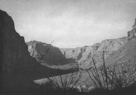
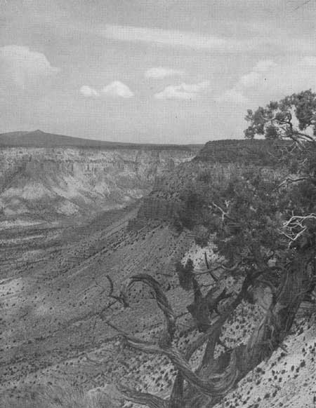
| Figure 72.—View across the inner gorge of the Colorado River from Bridge Canyon. |
|
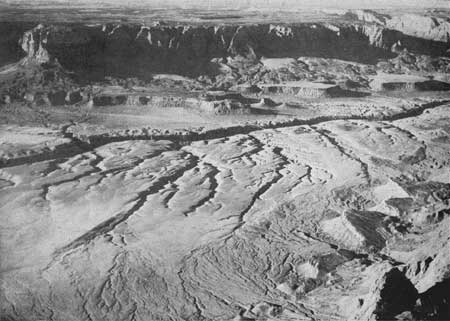
| Figure 73.—Where United States Highway 89 crosses Marble Gorge—Paria Plateau in the background. (Air photo) |
|
| Figure 74.—Mount Dellenbaugh from the rim of Green Springs Canyon, Shivwits Plateau. |
The Kanab Creek diversion proposal would, in effect, take away from the Grand Canyon the very agent that created it; the remaining trickle would be sham and mockery in comparison to the once great force that carved the canyon—the Colorado River. The natural river and its companion piece, the canyon, are vitally significant and interrelated elements of the whole which is Grand Canyon National Park. Without the normal flow of the river the significance and completeness of the park will be destroyed and the will of the people defeated in that the great spectacle of the Grand Canyon, as set aside by the Congress in the national park, to be preserved in its natural state for this and succeeding generations, will be seriously impaired.
NEXT >>>
 Top
Top
Last Modified: Mon, Sep 6 2004 10:00:00 pm PDT
http://www.cr.nps.gov/history/online_books/colorado/chap7a.htm
![]()