
|
Geological Survey Professional Paper 446
Geology of the Guadalupe Mountains, New Mexico |
TERTIARY IGNEOUS ROCKS
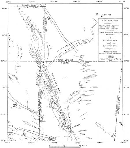
Three igneous dikes occur in the Castile Formation in secs. 11, 14, and 15, T. 26 S., R. 24 E., just west of U.S. Highway 62. The dikes strike about N. 60° E., dip about 80° N., and are 1,000 to 4,000 feet long on the outcrop. The dikes are more easily detected on vertical aerial photographs than on the ground where they generally appear as linear zones of brown-weathering soil. At one place near the west end of the northern dike, relatively fresh rock is exposed in a gully. Here, the dike is 6 to 7 feet thick. The rocks of the Castile Formation adjacent to the dike show no apparent alteration. The dike is made up of a fine-grained vesicular rock identified as alkali trachyte by P. H. Masson (Pratt, 1954, p. 143). Fragments of similar rock, identified by Masson (Pratt, 1954, p. 146) as trachyandesite, are scattered on the surface about 1,000 feet southeast of U.S. Highway 62 in NE1/4 sec. 31, T. 25 S., R. 25 E. These fragments were probably eroded from a dike or sill and perhaps were trapped in a sinkhole or solution channel in the Castile Formation in much the same way as the Cretaceous rock fragments discussed on page 37. Igneous rock is not known to occur elsewhere in the mapped area. The igneous rocks are post-Castile in age, and by analogy with igneous rocks of similar composition and known age found in many parts of southern New Mexico and western Texas they are probably Tertiary in age.
Other bodies of igneous rock are present in nearby areas. A small plug in the Bell Canyon Formation crops out about 15 miles to the southwest (fig. 24). The rock in this plug was tentatively identified by P. B. King (1948, p. 103) as trachyte. According to Pratt (1954, p. 146), this plug is on one of several low north-northwest-trending ridges of altered sandstone. Another nearby occurrence of igneous rock is a sill 410 feet thick in Carboniferous rocks at a depth of 8,730 feet in the Magnolia Homer Cowden 1 well about 14 miles south-southwest of the 3 dikes in the present mapped area. This sill rock was identified by Flawn (Pratt, 1954, p. 147) as leucosyenodiorite. All the above-mentioned igneous rocks are of similar composition and probably have a common source.
|
| FIGURE 24.—Tectonic map of Guadalupe Mountains region, New Mexico and Texas. Texas part of map adapted from P. B. King (1949). |
| <<< Previous | <<< Contents >>> | Next >>> |
pp/446/sec5.htm
Last Updated: 13-Feb-2008