
|
Geological Survey Professional Paper 446
Geology of the Guadalupe Mountains, New Mexico |
POST-PERMIAN DEPOSITS
CRETACEOUS ROCKS
No rocks of definite Cretaceous age crop out in the mapped area, but pebbles of limestone and sandstone containing marine fossils of early Washita (Early Cretaceous) age (Lang, 1947, p. 147-2) are scattered on the Castile Formation along a side road 400 feet southeast of U. S. Highway 62 in N1/2 sec. 31, T. 25 S., R. 26 E. Lang (p. 1474) suggested that these Cretaceous rock fragments were "trapped * * * in a deep sink or cavernous channel which later collapsed, and they have been preserved there while the enclosing rocks were eroded away." Inasmuch as solution features are common in the Castile Formation, the suggestion seems reasonable. Possibly other small areas of Cretaceous rock fragments are preserved in the Castile outcrop area, but no others have been found.
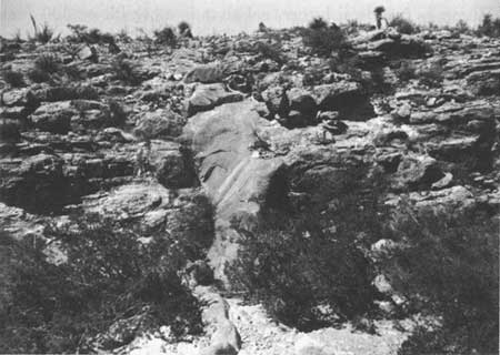
At several places along the top of the Reef Escarpment, joints in the Tansill Formation of Permian age are filled with quartzitic pebble-bearing sandstone dikes, and low areas on the ridge top resembling shallow sinks contain scattered quartz pebbles. The largest of the sandstone dikes were seen at the east rim of Slaughter Canyon in SW1/4 sec. 13, T. 25 S., R. 23 E., near the Reef Escarpment and at the head of a small canyon in S1/2 sec. 7, T. 25 S., R. 24 E. Dikes at both of these localities contain rounded granules and pebbles of quartzite, and a 10-foot-thick dike at the latter locality contains pebbles of limestone and siltstone as well. Other sandstone dikes of this type occur in Jurnigan Draw in NW1/4 sec. 17, T. 24 S., R. 24 E. (fig. 22). Similar conglomeratic sandstone was also found at the head of Yucca Canyon in SW1/4 sec. 28, T. 25 S., R. 23 E., and on the ridge top in NW1/4 sec. 24, T. 25 S., R. 23 E. Scattered quartz pebbles were found at many localities along the top of the Reef Escarpment between the mouths of Rattlesnake and Double Canyons.
|
| FIGURE 22.—Nearly vertical sandstone dike of probable Cretaceous age in the Capitan Limestone near its transition into the Tansill Formation in Jurnigan Draw. |
Horberg (1949, p. 466) examined some of these deposits and pebble localities and believed they were Ogallala (Pliocene) in age. P. B. King (1948, p. 140), on the basis of geomorphic and stratigraphic evidence, suggested that Cretaceous rocks may once have covered the Guadalupe Mountains, although he saw no remnants of them in the southern part of the range. An outlier of Cretaceous rocks is present on the crest of the Sacramento Mountains (Pray and Allen, 1956, p. 2735) about 95 miles to the northwest. This outcrop contains marine fossils of Cenomanian (early Late Cretaceous) or latest Albian (late Early Cretaceous) age in a shale overlying pebble-bearing quartz sandstone 150 feet thick which is similar to the pebble-bearing sandstone in the present mapped area. This occurrence of Cretaceous rocks on top of the Sacramento Mountains to the northwest, the occurrence of fossils of early Washita age on the Castile Formation to the southeast of the Guadalupe Mountains, and the presence of rocks of Washita age overlying Permian rocks in the vicinity of the Cornudas Mountains (King, P. B., 1949) about 55 miles west-southwest, together suggest that the pebble-bearing sandstone and scattered gravel along the Reef Escarpment are remnants or slightly reworked deposits of a once-extensive blanket of Cretaceous rocks of probable Washita age.
QUATERNARY
DEPOSITS
GRAVEL OF PLEISTOCENE AGE
Gravel, sand, and silt of probable Pleistocene age cover much of the Castile Formation, especially north and west of Black River. Most of the Mescal Wash area, south of Rattlesnake Canyon and west of Black River, is overlain by gravel that is as thick as 300 feet.
The northeastern part of T. 24 S., R. 26 E., is also covered by gravel that is at least 300 feet thick where penetrated by wells a few miles to the north. In both areas the gravel probably was deposited on an uneven erosion surface cut on the Castile Formation. Numerous gravel remnants occur at several levels between these two areas. The more conspicuous of these smaller comparatively thin deposits are shown separately on the geologic map (pl. 1), and some areas mapped as Castile Formation may be covered by low-level gravel of considerable thickness.
All the gravel deposits mapped consist of poorly sorted detritus ranging in size from silt to cobbles derived mostly from the Capitan Limestone and the carbonate facies of the Artesia Group. Quartzite pebbles probably derived from the Cretaceous rocks that presumably once covered the Guadalupe Mountains are also present in most of the gravel deposits. Most of the gravels are uncemented, but locally the upper surface has been consolidated by recent caliche. Scattered patches of gravel along Black River and below Blue Spring (sec. 33, T. 24 S., R. 26 E.) have been cemented by calcareous tufa of Recent age.
Relatively thin gravel deposits similar in composition to those on the Castile Formation cap most of the drainage divides in the Seven Rivers Embayment (fig. 1), but they were not mapped. Detritus in these deposits apparently was derived largely from the San Andres Limestone and from the Grayburg and Queen Formations in the Guadalupe Mountains.
Except for gravel of Recent age in modern arroyos in the Mescal Wash area, all the gravel deposits described above are older than those of the present erosion cycle and are tentatively assigned to the Pleistocene. Several cycles of erosion are suggested by the varying degrees of dissection and the different levels of the deposits. Horberg (1949, fig. 3) correlated the extensive gravel surface of the northeastern part of T. 24 S., R. 26 E., with the Orchard Park terrace as described by Fiedler and Nye (1933, p. 11-12) in the Roswell artesian basin about 20 miles north of the present area. The higher surfaces of the Mescal Wash were also tentatively correlated with the Orchard Park terrace by Horberg (1949, fig. 3). He correlated the dissected surface associated with the higher gravel remnants adjacent to the Reef Escarpment on both sides of White City to the older Blackdom terrace (Fiedler and Nye, 1933, p. 12), whereas he tentatively correlated most of the lower surfaces with the younger Lakewood terrace (Fiedler and Nye, 1933, p. 10-11). The dissected gravel surface of the Seven Rivers Embayment may represent the Blackdom terrace.
ALLUVIUM
Recent alluvial deposits border the larger drainage courses throughout the area, but the only ones mapped are those along Black River in the southeastern part of the area, and in Shattuck Valley, Dog and Upper Dog Canyons, and the Salt Flat in the western part. Elsewhere, the alluvial deposits have limited extent and are not shown on the geologic map (pl. 1).
The composition of all the alluvial deposits reflects the local bedrock. Finely divided gypsum comprises most of the alluvium in drainage courses on the Castile Formation, such as Cottonwood Draw, Ben Slaughter Draw, and Hay Hollow. Gypsum and limestone detritus make up most of the alluvium along Black River. Alluvium in the western tributaries of Black River consists of poorly sorted silt- to pebble-sized limestone detritus and minor quartz silt and sand derived from the Capitan Limestone and Artesia Group. The lower reaches of most of the larger canyons in the Reef Escarpment, from Big Canyon on the southwest to Elbow Canyon on the northeast, are floored with coarse detritus, as large as boulder size, derived from the same source. The large northeastward-trending canyons of the Guadalupe Mountains from Dark Canyon on the southeast to Siegrest Draw on the northwest contain poorly sorted coarse rubble derived from the bedrock along the upper reaches of the canyons. The lower reaches of these canyons in the Seven Rivers Embayment contain alluvium from the same sources, but the constituent fragments are smaller. Shattuck Valley, Dog and Upper Dog Canyons, and the Salt Flat all contain rather broad, but apparently relatively thin, alluvial deposits consisting predominantly of clay- to sand-sized detritus derived chiefly from the Yeso Formation, the San Andres Limestone, and the Grayburg and Queen Formations.
CALCAREOUS TUFA
Calcareous tufa deposits are common where springs issue from carbonate beds or carbonate gravel deposits. The largest accumulations of tufa are in the Last Chance Canyon drainage and along Black River valley.
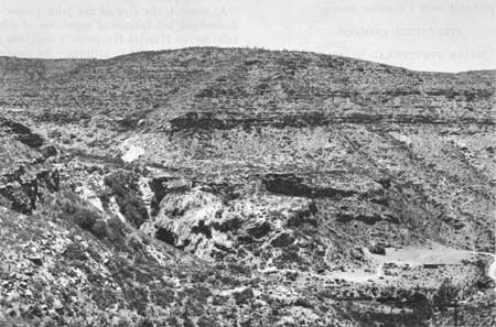
The largest single accumulation of tufa in the area is below Sitting Bull Spring (NE1/4 sec. 9, T. 24 S., R. 22 E.). This deposit covers the bottom of Sitting Bull Canyon for a distance of three-fourths of a mile and ends abruptly in a 1,000-foot-wide and nearly 200-foot-high cliff over which the water from Sitting Bull Spring drops in a narrow waterfall (fig. 23). A similar but smaller tufa deposit is present in White Oaks Canyon below White Oaks Spring (SW1/4 sec. 5, T. 24 S., R. 22 E.).
|
| FIGURE 23.—Calcareous tufa at Sitting Bull Falls. Rock picnic shelters and automobiles at lower right provide scale. Falls are visible as a small trickle near left edge of tufa dam. Sitting Bull Spring, out of view up the canyon, issues from tongue of the San Andres Limestone. |
Of numerous tufa accumulations along Black River valley, the largest are in the river, below Rattlesnake and Blue Springs, and at Black River Village. The tufa of Black River and environs cements the gravel deposits of the river.
The calcareous tufa deposits represent calcium carbonate precipitated from very limy spring water that lost carbon dioxide as it was warmed by the atmosphere, thus decreasing the solubility of calcium carbonate. Although algae, which use the carbon dioxide in the water, are often abundant in the spring-fed pools on the tufa, it is not known how important a part they play in the precipitation of the calcium carbonate. They probably contribute in a small way.
| <<< Previous | <<< Contents >>> | Next >>> |
pp/446/sec4.htm
Last Updated: 13-Feb-2008