
|
Geological Survey Professional Paper 446
Geology of the Guadalupe Mountains, New Mexico |
STRUCTURAL GEOLOGY
MAJOR STRUCTURAL ELEMENTS
The principal structural feature of the report area is the Guadalupe Mountains uplift (fig. 24). This uplift may be generally described as a gently northeastward tilted block bounded on the west by a zone of nearly en echelon normal faults of late Cenozoic age and on the east by a monoclinal fold of Cenozoic age, the Huapache monocline. The monocline apparently is superimposed on a zone of late Paleozoic thrust faults. The southeast margin of the Guadalupe Mountains uplift coincides with the Reef Escarpment which may have resulted partly from Cenozoic rejuvenation of a late Paleozoic fold, the Bone Spring monocline. Adjacent to this monocline on the northwest is a zone 5 miles wide characterized by the broad northeastward-plunging Walnut Canyon syncline and Guadalupe Ridge anticline.
West of the Guadalupe Mountains is a graben area occupied by Big Dog and Upper Dog Canyons. This area is bounded on the west by a north-northwestward-trending zone of normal faults of late Cenozoic age in and adjacent to the Brokeoff Mountains. Only the extreme north end of this fault zone lies in the report area.
Strata to the northeast and southeast of the Guadalupe Mountains are relatively undisturbed and, in general, dip gently east to northeast.
OLDER STRUCTURAL FEATURES
HUAPACHE THRUST ZONE
The only pre-Permian structural element known in the report area is a buried fault zone along the east side of the main Guadalupe Mountains block. The displacement, attitude, trend, and age of the fault zone are suggested by logs of deep oil tests drilled in the Guadalupe Mountains and the Seven Rivers Embayment. One well, the Humble Huapache 1 (sec. 35, T. 23 S., R. 22 E.) on the east flank of the Guadalupe Mountains, penetrated at least two and possibly as many as five faults. The nature and thickness of Mississippian, Pennsylvanian and Lower Permian rocks penetrated in several other wells indicate that the fault zone is very nearly coincident with the present east boundary of the northern Guadalupe Mountains, that it was apparently intermittently active through all or most of Pennsylvanian time and possibly Early Permian time, and that the fault zone defined the east boundary of a rising positive area.
At present, the dips of the fault planes cannot be determined, but because of repetition of stratigraphic units in the Humble Huapache 1 well, the faults are known to be reverse in attitude. By comparing logs of two wells drilled to the west and to the east of the fault zone (Union White 1 and Humble Huapache 2), it is apparent that rocks on the west sides of the faults are upthrown. Comparison of the Continental-Standard of Texas Bass 1 and the Continental East Texas Hill 1 establishes the strike of the fault zone as about N. 35° W. Because no faults were detected in the Humble Huapache 2 it is unlikely that the fault planes dip at a low angle. They apparently dip westward 45° to 85°. Abnormal thicknesses of stratigraphic units above and below the major faults found in the Humble Huapache 1 indicate that the rocks are dipping eastward as much as 60°, and possibly much more, throughout a vertical interval of nearly 4,000 feet. Because this seems excessive for drag folding along a fault, the dipping rocks are interpreted to be part of a thrusted fold. The fault zone could be a normal fault zone which was later folded and overturned early in Permian time, but this seems unduly complicated. Thrust faults of Pennsylvanian age cut surface rocks in the Marathon uplift (King, P. B., 1937, p. 134-136), 160 miles to the southeast (fig. 3), and reverse faults may be present as close as 70 miles northwest in the Sacramento Mountains (G. O. Bachman, oral communication, 1959). These faults indicate that the entire region was subjected to compressional forces during Pennsylvanian time.
Mississippian rocks underlying the area show no important lithologic change from one side of the fault zone to the other, but they are vertically displaced by as much as 4,000 to 6,000 feet and are found twice in the Humble Huapache 1 well; therefore, the faulting must be post-Mississippian in age. On the other hand, the Permian San Andres Limestone, which lies at the surface over the fault zone, is not ruptured; so the faulting must be pre-Guadalupe in age.
Pennsylvanian rocks in a sequence about 1,800 feet thick were found in the Union White 1 well on the west or upthrown side of the fault zone and a Pennsylvanian section, nearly 4,500 feet thick, was found in the Humble Huapache 2, drilled on the downthrown side of the fault zone. The rocks in both wells are reported to contain fusulinids ranging in age from Early to Late Pennsylvanian. Slow but continuous movement or slight intermittent movements along the faults could have kept the area to the west near effective wave base so that it received less than half as much sediment as the area to the east. If all or nearly all the movement on the faults took place within a relatively short interval of time, the upthrown fault block would probably have been raised above sea level and eroded, and the rocks would not contain a complete sequence of fusulinids.
The Hueco Limestone and Yeso Formation of Wolfcamp and Leonard age are both thinner on the west side of the fault zone than on the east side, indicating that some movement on the faults probably persisted into Early Permian time. In the Continental East Texas Hill 1 well, drilled about 2 miles east of the fault zone, a 2,200-foot sequence of rock is reported to contain anomalously mixed Late Pennsylvanian and Early Permian fusulinids. This suggests that movement took place in the fault zone near the close of Pennsylvanian time and (or) early in Permian time, and that Late Pennsylvanian fusulinids which had been deposited on the uplifted west side of the fault zone were locally eroded and transported eastward early in Permian time.
The fault zone is reflected today on the surface by the low eastward-dipping Huapache monocline. Inasmuch as the Huapache monocline affects rocks of late Guadalupe age, it appears that minor post-Guadalupe, probably Tertiary, movement has taken place along the old zone of weakness.
Vertical movement along the Huapache thrust zone was apparently greater in the vicinity of Texas Hill than it was to the south near Last Chance Canyon. Near Last Chance Canyon 1,500 to 2,000 feet of Pennsylvanian rocks are present on the upthrown side of the fault zone in the Union White 1 and the Humble Huapache 1 and 3 wells. On the other hand, in the Continental-Standard of Texas Bass 1 drilled on Texas Hill, no Pennsylvanian rocks were found. The presence of Late Pennsylvanian fusulinids mixed with Early Permian fusulinids in the Continental East Texas Hill 1 may indicate that some Pennsylvanian sediments were deposited in the area now occupied by Texas Hill, but later movement along the fault zone raised the area above the base level and all Pennsylvanian rocks and several hundred feet of Mississippian rocks were removed by erosion (section A—A', pl. 1). Even greater uplift is indicated northwest of Texas Hill. In the Standard of Texas Scarp Unit 1 (sec. 18, T. 21 S., R. 18 E.), 8 miles west of the northwest corner of the mapped area, all Mississippian and Pennsylvanian rocks are missing, and a very thin section of Hueco Limestone rests directly on Devonian rocks.
How far southeast of the Last Chance Canyon area the thrust zone extends is not known. The fact that the reported thickness of the sequence from the base of the Mississippian System to the top of the Leonard Series in the Superior Federal 1—134 well (sec. 12, T. 26 S., R. 24 E.) is nearly 3,000 feet less than the same sequence in the Gulf Estill 1—AD (sec. 29, T. 24 S., R. 26 E.) suggests that the former well was drilled over a buried highland. The Huapache thrust zone may well extend into the Delaware basin between the two wells.
The Pennsylvanian positive area to the west of the Huapache thrust zone may be a southeastward extension of the Pedernal land mass of Torrance County, described by Thompson (1942, p. 12), or it may be one of a chain of smaller positive elements (fig. 3). As shown by Foster (1959), in most wells drilled in the eastern foothills of the Sacramento Mountains northwest of the present report area, Pennsylvanian rocks are either thin or missing. In the Sierra Diablo, about 60 miles to the south, a positive area is present in which Permian rocks rest on rocks ranging in age from Precambrian to Pennsylvanian (King, P. B., and Knight, J. B., 1944). The position and nature of the west edge of the positive element or chain of elements in the latitude of the report area cannot be determined accurately at present.
BONE SPRING MONOCLINE AND BONE SPRING ARCH
Late in Leonard time and early in Guadalupe time, a broad southeastward-dipping fold, the Bone Spring monocline, formed along the basinward edge of the Victorio Peak Limestone. The folded rocks are not exposed in the report area, but they are exposed near the south end of the Guadalupe Mountains in Texas. The fold has been described by P. B. King (1948, p. 18-19). The monocline is presumed to continue northeastward beneath the surface of the mapped area where it is believed to form the southeast flank of an arch 15 to 20 miles wide. Blanchard and Davis (1929, p. 964) apparently had such a feature in mind when they originally named the "Bone Springs" arch, but their interpretations of the stratigraphy adjacent to the northwest side of the arch differ from those presented here.
In his description of the effects of the Bone Spring monocline on Permian sedimentation, P. B. King (1948, p. 19) stated that the "upraised limestones were being eroded in early Delaware Mountain time, and the Brushy Canyon formation of that group overlaps their sloping surface. The overlap is so great that 1,000 feet of beds, the entire Brushy Canyon formation, is cut out." In areas to the northwest of the monocline, the contact between the Cutoff Shale and the sandstone tongue of the Cherry Canyon Formation is apparently an unconformity representing all Brushy Canyon time. The unconformity present at the base of the sandstone tongue of the Cherry Canyon Formation in Last Chance Canyon (stratigraphic section 9, pl. 3) is probably a continuation of that unconformity, and rocks of Brushy Canyon age are apparently absent there. However, as shown on page 28, about 580 feet of rock in the middle part of the San Andres Limestone on Algerita Escarpment is apparently of Brushy Canyon age. A northwest flank of the Bone Spring arch is thus implied although direct evidence for its existence has not been observed. If present, the northwest flank should be exposed on the Big Dog Canyon scarp somewhere in T. 24 S., R. 20 E., but Tertiary faulting and slumping have obscured the relations.
The Bone Spring arch was almost completely buried by the close of Brushy Canyon time, and it had little effect on sedimentation during most of early Cherry Canyon and late San Andres time. Near the end of San Andres time, however, a narrow subsidiary arch formed near the northwest flank of the main Bone Spring arch. This subsidiary arch is indicated by the slight angular unconformity between the San Andres Limestone and overlying Grayburg Formation in Last Chance Canyon (stratigraphic sections 1, 7, 8, 9, pl. 3). An unconformity at the same stratigraphic position occurs near Berlin Tank in the southern part of the Brokeoff Mountains (Hayes, 1959, p. 2211) and is probably due to erosion on an extension of the same small arch. Blanchard and Davis (1929, pl. 11) show what may be the same subsidiary arch as the Tank Canyon arch near the northwest edge of their "Bone Springs" arch. The subsidiary arching ceased by the beginning of Grayburg time, and the Grayburg Formation was deposited across the fold with no apparent thinning.
The Bone Spring flexure was probably slightly rejuvenated at about the same time as the subsidiary arch formed. The resultant southeast-facing dipslope on the sandstone tongue of the Cherry Canyon Formation thus formed an accentuated northwest margin for the Delaware basin. This accentuated basin margin had a profound control on later Permian sedimentation.
CENOZOIC STRUCTURAL FEATURES
FOLDS
Two systems of folds involving the San Andres Limestone and Artesia Group at the surface interrupt the northeastward regional dip of about 1° to 2°. These are the north-northwestward-trending Huapache monocline and its related structures and the northeastward-trending folds that parallel the Reef Escarpment on its northwest side. In addition to these are folds related to faults in the Brokeoff Mountain-Big Dog Canyon area and other minor irregularities, some of which are probably solution and collapse features.
The east-northeastward-dipping Huapache monocline is a prominent fold that extends from the Reef Escarpment between Rattlesnake and Slaughter Canyons to a point beyond the north edge of the mapped area (pl. 1; fig. 24). It may also extend southeastward across the older Bone Spring monocline into the Delaware basin. It resulted from post-Permian flexing along the trend of the late Paleozoic Huapache thrust zone. Maximum dips along the monocline in the San Andres Limestone and younger rocks that form the surface generally range from 5° to 8°. The width of the fold is generally less than 2 miles, and the difference in elevation of equivalent beds on opposite sides is about 1,000 feet.
Closely associated with the Huapache monocline is the asymmetrical Texas Hill dome. Its axis is parallel to the trend of the Huapache monocline, and the relatively steep east flank of the dome merges with the monocline. The west flank of the dome is formed by a slight reversal of the gentle regional dip. The total structural closure on the dome at the surface is apparently less than 100 feet. The crest of the structure is at about the summit of Texas Hill.
The folds that parallel the Reef Escarpment on its northwest side may also be indirectly related to an older structural feature, the Bone Spring monocline of Early Permian age. As stated above, the Bone Spring monocline may have controlled the position of the Capitan Limestone. An original sedimentary dip of 20° to 30° in the reef breccia beds of the Capitan Limestone has apparently been increased as much as 10° by Cenozoic tectonism. The tectonic component of dip on the Reef Escarpment forms the southeast flank of a long sinuous anticline whose gently dipping northwest limb is the southeast limb of the northeast-plunging Walnut Canyon syncline (pl. 1; fig. 24). The Walnut Canyon syncline, whose axial trace is about 1 mile northwest of the crest of the Reef Escarpment, extends from Big Canyon to near the mouth of Walnut Canyon, a distance of nearly 25 miles. The maximum dips on the northwest flank of the syncline average 6° and locally are as great as 9°; the southeast flank rarely dips more than 1° or 2°. For much of its length, the axial trace of the Walnut Canyon syncline nearly coincides with West Slaughter, South Rattlesnake, and Walnut Canyons. The steeper northwest limb of the Walnut Canyon syncline is the southeast limb of the asymmetrical northeast-plunging Guadalupe Ridge anticline whose axial trace is near the crest of Guadalupe Ridge. Dips on the northwest limb of this anticline are also very gentle and barely exceed 1°. The structural contours indicate one more indistinct shallow, northeast-plunging syncline adjacent to the Guadalupe Ridge anticline on the northwest. These folds that parallel the Reef Escarpment are presumed to be Laramide in age. They are obviously post-Permian inasmuch as they affect Permian rocks, and apparently they antedate the development in early and middle Tertiary time of Carlsbad Cavern, for the open joints that controlled the solution of the limestone are probably tension joints that formed during the folding.
Other small undulations in the carbonate surface rocks in the northern part of the Guadalupe Mountains, as shown on the geologic map (pl. 1), are probably tectonic in origin. Undulations in the outcrop areas of the evaporite member of the Seven Rivers Formation and the Castile Formation are probably at least partly due to solution and collapse of evaporite beds.
FAULTS
Many closely spaced faults trend north to northwest along the west edge of the geologic map area (pl. 1). Several faults of small displacement also parallel the Reef Escarpment, but only one near White City was considered of sufficient magnitude to show on the map. Linear features in the Castile Formation may be faults of small displacement and are described on page 46.
The faults on the west side of the area are assigned to three groups: (a) those along the Guadalupe Mountains scarp north of Stone Canyon, (b) those parallel to the Shattuck Valley scarp south of Stone Canyon, and (c) those in and north of the Brokeoff Mountains.
The Guadalupe Mountains scarp from Stone Canyon northward is characterized by numerous closely spaced high-angle faults which are parallel or subparallel to that scarp. Dip slip is probably predominant. Nearly all these faults are downthrown on the west, but a few short faults have the opposite displacement. Only one of the latter kind, in the northeastern part of T. 25 S., R. 20 E., is shown on the geologic map (pl. 1). It was possible to measure accurately the dips of only 2 faults, which were 86° and 87° W. The traces of these faults suggest that all but those near the north end of the scarp dip at high angles. Toward the north the principal faults in the scarp may dip as low as 60° to the west. Stratigraphic displacements of faults high on the scarp rarely exceed 100 feet, but 2 faults that are mostly buried beneath alluvium in Big Dog Canyon have maximum stratigraphic displacements of about 800 feet where they are exposed low on the scarp. A group of en echelon faults between Sixshooter and Stone Canyons dies out southward into a relatively steep west-dipping flexure that forms the east side of a syncline occupied by the lower end of Upper Dog Canyon. Near the north end of the mapped part of the scarp, the largest fault apparently splits into a series of "horsetail" faults of smaller displacement. These faults, like those farther south on the scarp, are mostly high-angle dip-slip faults downthrown on the southwest from a few feet to at least 300 feet. Beds in fault slices near Sixshooter Canyon and at the north edge of the mapped area in the Guadalupe Mountains scarp dip away from the mountains so that, in effect, the scarp is a faulted monoclinal fold, whereas between these two areas the beds in the fault slices dip mountainward, suggesting that some of the displaced blocks may be large landslides.
The faults paralleling the Shattuck Valley scarp are separated from the faults at the south end of the main Guadalupe Mountains scarp by an unfaulted monoclinal fold about 1-1/2 miles wide. Most of the displacement on the Shattuck Valley scarp is along one long fault high in the scarp, although some displacement is taken up by a smaller fault. The larger fault can be traced for about 13 miles from north of El Paso Gap southward into a fault which P. B. King (1948, pl. 20) called the Dog Canyon fault. It has an arcuate trace convex to the east, and the average strike is a little east of north. The fault plane was nowhere seen, but it probably dips to the west at a high angle. Stratigraphic displacement along the fault is as much as 800 feet locally. Adjacent to the fault, beds on the down-dropped side dip sharply to the west with dips as great as 70° and are cut by strike faults of small displacement (Boyd, 1958, p. 56). None of these small faults are shown on the geologic map (pl. 1). The steep westward-dipping beds on the west side of the fault flatten out under the alluvium of Shattuck Valley and, on El Paso Ridge on the west side of the valley, the dip is as much as 14° to the east, thus forming a syncline. On the west side of Upper Dog Canyon near the southwest edge of the mapped area is another arcuate fault, downthrown on the east, which parallels the fault on the Shattuck Valley scarp. Upper Dog Canyon, therefore, is a combination graben and syncline.
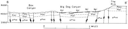
The faults in and north of the Brokeoff Mountains are a closely spaced complex of northwestward-striking faults, most of which are downthrown on the east side. A few faults, particularly toward the north, are downthrown on the west so that the area contains several narrow grabens and horsts. Stratigraphic displacement on the faults range from a few feet to as much as 600 feet. Two of the fault planes dip 60° and 80°; dips of the others could not be measured. Most of the faults appear to be normal faults that dip at high angles. The Brokeoff Mountains fault zone and the main fault zone of the Guadalupe Mountains are separated by a graben occupied by Big Dog Canyon (pl. 1; fig. 25). Just beyond the west edge of the mapped area the two fault zones merge and form a profusion of subparallel faults along the Guadalupe Mountains scarp.
|
| FIGURE 25.—Section B—B' across Big Dog Canyon. (See pl. 1 for line of section.) Qal, alluvium; Psau, upper member of San Andres Limestone; Psal, lower cherty member of San Andres Limestone; pPsa, pre-San Andres rocks. |
Relatively steeply dipping strata in the northern part of the Brokeoff Mountains and the central part of the Guadalupe Mountains scarp owe their dip to their inclusion in tilted fault slices. Dipping strata on the west side of the Dog Canyon fault and at the north and south ends of the Guadalupe Mountains scarp may be attributed to drag folding, at least in part. Folded and inclined strata on the east side of Martine Ridge, on El Paso Ridge, on the west side of Upper Dog Canyon, and elsewhere, however, cannot be so easily related to faulting. It is possible that either mild compressive forces from the northeast or southwest, or differential uplift perhaps due to faulting in the subsurface, produced a broad anticline in the position of the Brokeoff Mountains, a syncline or series of en echelon synclines in the position of Big Dog and Upper Dog Canyons, and slight warping of the Huapache monocline. The system of normal faults on the west side of the Guadalupes may have formed perhaps as a result of release of compression or a result of uplift. In the Texas part of the Guadalupe Mountains, P. B. King (1948, p. 125) reported no evidence of compression at the surface and suggested that—
the Guadalupe and Delaware Mountains may have arisen as a result of deep-seated compression, manifested at the surface by essentially vertical uplift, which put the surface rocks under tension, thereby producing along the crest of the uplifted region an extensive system of tension joints and normal faults.
On the basis of his detailed studies and regional considerations, P. B. King (1948, p. 125) dated the normal faults of the Guadalupes as late Pliocene and early Pleistocene.
The short normal faults of very small displacement parallel to the Reef Escarpment, such as the one mapped in Walnut Canyon near White City, probably originated as tension joints on the crest of the narrow anticline adjacent to the Reef Escarpment.
JOINTS
No systematic study of joints was made, but some of the jointing observed is of special interest.
The Capitan Limestone and adjacent parts of the Artesia Group contain a conspicuous system of nearly vertical joints that parallel the Reef Escarpment. Associated with these are less conspicuous joints that trend at right angles to the Reef Escarpment. These intersecting joints formed the avenues for solution of such caves as Carlsbad Cavern and New, Goat, and Lechuguilla Caves. (See table 1.) Many of the joints parallel to the Reef Escarpment contain sandstone dikes of probable Cretaceous age, described on page 37. Numerous small drainage courses are controlled by this set of joints. Among these are Calamity Cove and Lefthook, Yucca, Nuevo, and Fence Canyons.
The fact that these joints are everywhere parallel or at right angles to the Reef Escarpment, no matter what its trend, suggests a relation between the Capitan Limestone and the joints. Sandstone dikes of probable Cretaceous age in some of the joints indicate that they were opened before late Early Cretaceous time. Possibly they were formed soon after deposition of the Permian rocks by differential compaction of rocks in the Northwest-shelf area and the Delaware basin, or they may have been formed during post-Permian regional uplift by tensional stresses resulting from differential movement between the shelf and the basin. Some of the joints may have been enlarged and others may have formed concurrent with the folding of the Walnut Canyon syncline and related structures in Tertiary time.
Another type of jointing that is peculiar to the Capitan Limestone is sheeting parallel to the present erosion surface. Sheeting occurs locally along the Reef Escarpment and on the walls of some of the canyons which cut through the escarpment. The sheeting can be easily confused with the crudely developed bedding in the breccia member, which is subparallel to the surface of the Reef Escarpment. The type of sheeting or exfoliation noted in the Capitan Limestone is often well developed in granitic rocks, but it is rarely observed in sedimentary rocks. Similar jointing in massive sandstones of the Colorado Plateau was described by Bradley (1958, p. 1724).
Other joints in the area are more obviously directly related to structural features of Tertiary age. Along the west edge of the area are numerous closely spaced joints parallel to the faults there. These are particularly prominent along The Rim on the west edge of the Guadalupe Mountains. Less closely spaced joints of north-northwesterly trend are present in limestone and dolomite throughout the Guadalupe Mountains.
LINEAR FEATURES IN CASTILE FORMATION
Low scarps in the Castile Formation trend about N. 75° E. across the Yeso Hills in the southwestern part of the Castile outcrop area. Some of the scarps are several miles in length and are as high as 50 feet. They face south or north and bound relatively flat valleys or ridges that resemble horsts or grabens ranging from a few hundred feet to more than a mile in width. Such linear features are present in the Castile Formation for nearly 30 miles south into Texas; they were mapped by P. B. King (1949) and described in detail by Olive (1957).
The scarps are apparently the traces of shallow faults of small displacement. Olive (1957) has described the grabens between the scarps as "solution-subsidence troughs." He believes that gypsum is dissolved along underground drainage channels following fractures that closely parallel the regional dip direction and that when the roofs over the channels can no longer be supported, collapse ensues. In Olive's words (p. 357)—
The collapse debris forms a barrier across the channels and causes the underground drainage to seek passage * * * along near-by fractures, which also approximate the trend of the regional dip. Subsidence that gives rise to troughs probably is not the result of a single cavern but of several.
The presence of small caverns and sinks, the irregular topography in the troughs, and the existence of gypsiferous springs (Ben Slaughter, Cottonwood, and Jumping Springs) to the east of the troughs in a downdip direction all support Olive's theory on the origin of the troughs.
| <<< Previous | <<< Contents >>> | Next >>> |
pp/446/sec6.htm
Last Updated: 13-Feb-2008