![]()
Cover Page
MENU
![]() Minidoka
Minidoka
|
| |
Confinement and Ethnicity: An Overview of World War II Japanese American Relocation Sites by J. Burton, M. Farrell, F. Lord, and R. Lord |

|
|
| |
Chapter 9 (continued)
Minidoka Relocation Center
Central (Fenced) Area
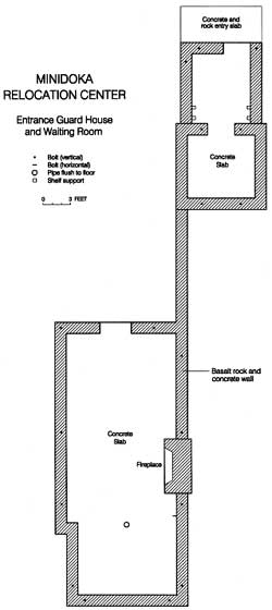 Figure 9.9. Plan map of guard house and waiting room at Minidoka. |
With a few notable exceptions, beyond the Bureau of Reclamation parcel little remains of the relocation center. Most of the central area is now cultivated fields of alfalfa, potatoes, and other crops (Figure 9.13). Concrete rubble from cleared building foundations has been pushed to the perimeter of many fields.
At least two buildings remain: Firehouse No. 1, which is now serves as a barn, and a root cellar, which is abandoned and in danger of collapsing (Figures 9.14 and 9.15). Adjacent to the root cellar are seven concrete slabs from buildings in the warehouse area (Figure 9.16). In the former administration area there is a concrete slab, with a rock alignment nearby. At least 100 feet long, the rock alignment may be the remains of a low wall or ditch. There is also a manhole, a rock alignment, and small concrete slab in the adjacent staff housing area (Figure 9.17).
Some of the farm houses and outbuildings in the central area appear to be recycled barracks or other relocation center buildings, but most have undergone extensive remodeling, with new siding and additions (Figure 9.18). The relocation center water wells appear to be still in use. The sewage disposal plant location is now a cultivated field.


 Top
Top
Last Modified: Fri, Sep 1 2000 07:08:48 pm PDT
http://www.cr.nps.gov/history/online_books/anthropology74/ce9c.htm
![]()