MENU
|
| |
Confinement and Ethnicity: An Overview of World War II Japanese American Relocation Sites by J. Burton, M. Farrell, F. Lord, and R. Lord |

|
|
| |
Chapter 16 (continued)
Assembly Centers
Sacramento Assembly Center, California
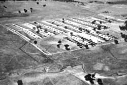
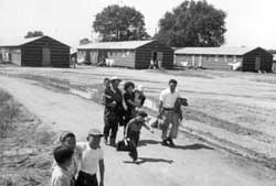
Constructed at a migrant workers camp 15 miles northeast of downtown Sacramento, this assembly center was also known as Walerga. It was occupied for 52 days, from May 6 to June 26, and held a total of 4,770 persons, with at maximum at one time of 4,739. Evacuees were from Sacramento and San Joaquin counties. Aerial photographs indicate there were 11 blocks with over 225 buildings (Figures 16.37 and 16.38); one block was likely devoted to the military police and administration.
 Figure 16.37. Oblique aerial view of the Sacramento Assembly Center. (from DeWitt 1943) |
 Figure 16.38. Sacramento Assembly Center. (National Archives photograph) |
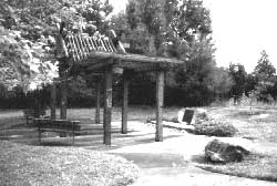
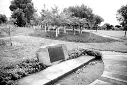
The assembly center area is now bisected by Interstate 80 and covered by recent housing subdivisions in what is now the "Foothill Farms- North Highlands" area of Sacramento. There is a historical marker, a ramada, and a small grove of cherry trees at a small neighborhood park and playground (Walerga Park) at the northwest corner of Palm Avenue and College Oak Drive, within what once was the assembly center (Figure 16.39). The monument incorporates a small concrete slab that may be a remnant assembly center foundation (Figure 16.40).
 Figure 16.39. Ramada and historical marker at Walerga Park. |
 Figure 16.40. Historical marker and grove of cherry trees at Walerga Park. |
 Top
Top
Last Modified: Fri, Sep 1 2000 07:08:48 pm PDT
http://www.cr.nps.gov/history/online_books/anthropology74/ce16i.htm
![]()

