![]()
Cover Page
MENU
![]() Tule Lake
Tule Lake
|
| |
Confinement and Ethnicity: An Overview of World War II Japanese American Relocation Sites by J. Burton, M. Farrell, F. Lord, and R. Lord |

|
|
| |
Chapter 13 (continued)
Tule Lake Relocation Center
Outlying Areas
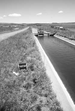 Figure 13.67. M" Canal today. |
Farm Fields and Ditches
Around the perimeter and within the central area there are two large concrete-lined irrigation canals, at least one of which ("M" Canal) was lined by the evacuees (Figure 13.67). Other outlying ditches constructed or used by the relocation center are still in use as well. The portion of Farm Area 1 east of the central area is private land still under cultivation; the part of Farm Area 1 north of the central area is apparently used for grazing. Farm Area 2, west of the central area, is now part of the Tule Lake National Wildlife Refuge.
The farm kitchen located within Farm Area 1 is still standing, but abandoned. The building is pretty well overgrown by trees, bushes, and other vegetation (Figure 13.68). Irregular in shape, it appears to be a combination of at least two buildings salvaged and reconstructed at the site. It has a partial concrete slab, an interior bathroom, and an interior door that reads "diet kitchen" (Figure 13.69).
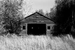 Figure 13.68. Tule Lake Relocation Center farm kitchen today. |
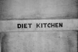 Figure 13.69. Detail of interior door at the Tule Lake Relocation Center farm kitchen. |
Hog and Chicken Farms
The site of the hog and chicken farms is now within the Tule Lake Wildlife Refuge, which limits access during the nesting season. From the Peninsula overlooking the hog and chicken farms, distinctive patterns in the grass are easily visible showing the outlines of former buildings, fences, and roads (Figures 13.70 and 13.71). Most notable is the red cinder road that was once around the perimeter. There are intact manholes at the hog farm, and at the southern end of the hog farm there are the concrete foundations of the slaughterhouse, other structures, and a watch tower (Figures 13.72-13.77). There is also a dilapidated well house (Figure 13.78), with inscriptions in its 5-foot-by-5-foot concrete floor (Table 13.3, Figures 13.79 and 13.80).
Table 13.3. Inscriptions at the Tule Lake Hog Farm (all in English).
|
1943 Charles Kodowaki Pre-Segregation |
Figures 13.79 and 13.80 |
|
TULE LAKE WATER WAGON 200-06 |
Figure 13.80 |
|
George Ohano 8/12/43 |
Figure 13.80 |
|
Ted Ohi 8/12/43 |
Figure 13.80 |
|
Aki Hamasaki 8/12/43 |
Figure 13.80 |
Horse corral
At the horse corral location, across Highway 139 from the central area, there are two badly weathered concrete slabs (Figure 13.81) and several concrete bases with imbedded metal straps which supported the roof columns of the stable. At the southwest end of the corral there are several half-buried, in-line creosoted poles apparently delineating that edge of the corral, surrounded by red cinder gravel used for a road. There are more red cinders at the forage shed location (Figure 13.82).


 Top
Top
Last Modified: Fri, Sep 1 2000 07:08:48 pm PDT
http://www.cr.nps.gov/history/online_books/anthropology74/ce13k.htm
![]()