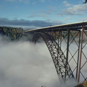
NPS / Louise McLaughlin The completion of the New River Gorge Bridge on October 22, 1977 solved a travel challenge. The bridge turned a 40-minute drive into less than a minute. It removed the need to navigate down narrow mountain roads across an ancient river. When it comes to road construction, mountains do pose a challenge. At New River Gorge, the challenge transformed into a work of structural art. The New River Gorge Bridge is the longest steel span in the western hemisphere. It is also the third highest bridge in the United States. The New River Gorge Bridge is one of the most photographed places in West Virginia. In 2006, the U.S. Mint chose the bridge to represent West Virginia on the state commemorative quarter. In 2013, the National Park Service listed the New River Gorge Bridge in the National Register of Historic Places. This listing signifies the importance of the bridge as a historic resource. 
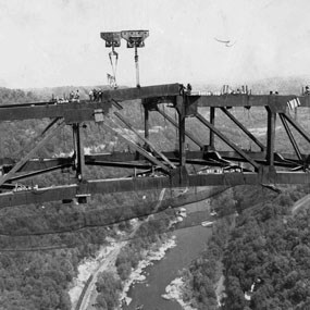
NPS Bridge ConstructionBefore construction could begin, someone had to design the bridge. Crossing a wide, deep gorge was no easy task. The West Virginia Division of Highways chose the Michael Baker Company for this task. They designed a single span arch bridge 3,030 feet long and 876 feet above the New River. The American Bridge Division of U.S. Steel received the construction contract. In June 1974, trolleys positioned the first steel over the gorge. These trolleys ran on three-inch diameter cables. The cables were strung 3,500 feet between two matching towers. To avoid the need to paint, workers built the bridge from Cor-ten steel. Cor-ten steel has a rust-like appearance that never needs painting. Three years later, construction was complete and the bridge opened. Communities long separated by the deep gorge were now connected at last. New River Gorge Bridge TodayAs US Highway 19, the New River Gorge Bridge continues to connect communities. Visitors can view the bridge from overlooks at Canyon Rim Visitor Center. The Long Point trail provides excellent bridge views from a rocky outcropping. The New River Gorge Bridge is a highway, not a pedestrian bridge. There is no way to walk on top of the bridge except on Bridge Day. Visitors that want to walk underneath the bridge can schedule a tour with Bridge Walk. Bridge Walk is the only company that take visitors on the bridge. They offer 3-hour tours on the maintenance catwalk underneath the bridge. Bridge Quick Facts

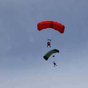
NPS / John Chapman Bridge DayOn the third Saturday of October, the Fayette County Chamber of Commerce hosts "Bridge Day." On this one day a year, the famous New River Gorge Bridge is open to pedestrians. A wide variety of activities draw thousands of people. Visitors experience great views, vendors, BASE jumping, rappelling, music, and more. Bridge Day is not only West Virginia's largest one-day festival but also the largest extreme sports event in the world. The first official Bridge Day was in 1980 when two parachutists jumped from a plane onto the bridge. Three more parachutists joined them and all five jumped from the bridge into the gorge. Today, the event lures hundreds of BASE jumpers, cheered on by thousands of spectators. "BASE" stands for Building, Antenna, Span, and Earth. These are the four categories of objects in which BASE jumpers jump from. Spans include arches or bridges like the New River Gorge Bridge. Bridge Day is an event hosted by the Bridge Day commission. For more information, visit the Official Bridge Day website, or call the New River Convention and Visitors Bureau at (800) 927-0263. Please be aware: Pets, bicycles, carts, and strollers are not permitted on the bridge during Bridge Day. Coolers, packages, and large packs or satchels will not be permitted on the bridge for security reasons. 
NPS DirectionsThe New River Gorge Bridge is located on U. S. Route 19, just north of Fayetteville, WV. It is easily reached from Interstates 64, 77, & 79 and from U. S. Route 60 (Midland Trail). It is approximately 30 minutes north of Beckley, 70 minutes east of Charleston, and 70 minutes south of Interstate 79. On the north side of the bridge, Canyon Rim Visitor Center provides outstanding overlooks of the bridge. If you have the time, consider driving the Fayette Station Road for some fantastic views from underneath the bridge. |
Last updated: September 26, 2025
