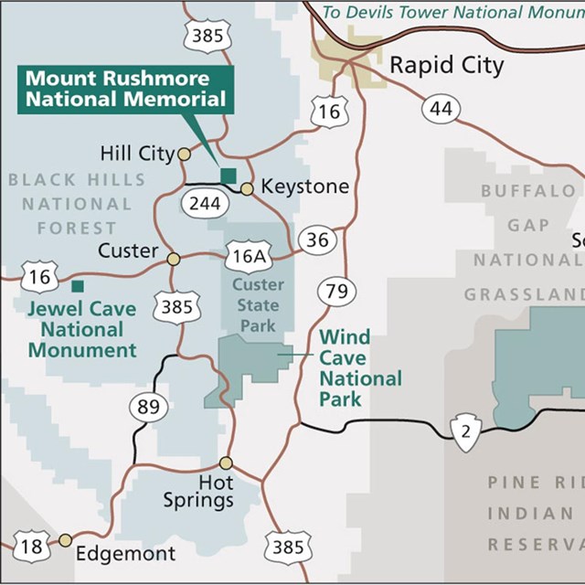
National Park Service LogoU.S. Department of the InteriorNational Park ServiceNational Park Service
National Park Service:  U.S. Department of the InteriorNational Park Service Arrowhead
Mount Rushmore National Memorial Rushmore coming out of the fog
view map
text size: largest larger normal
printer friendly
Mount Rushmore National Memorial
Directions
 

Getting Here:

Plane

Rapid City Regional Airport is located 35 miles from Mount Rushmore National Memorial on Highway 44.

Car

Visitors traveling by car on I-90 should exit at Rapid City and follow U.S. Highway 16 southwest to Keystone and then Highway 244 to Mount Rushmore. Visitors coming from the south should follow Highway 385 north to Highway 244, which is the road leading to the memorial.

Public Transportation

Rental cars or private tour companies can bring visitors to the memorial from Rapid City, SD. Personal vehicles are the most common form of transportation. No public transportation options are available.

Getting Around

Mount Rushmore National Memorial facilities are concentrated in a central area with pedestrian access from parking. Plan on at least a 2 hour stay to fully enjoy the memorial.

You are exiting the National Park Service website

Thank you for visiting our site.

You will now be redirected to:

We hope your visit was informative and enjoyable.

Jefferson on Washington's left

Did You Know?
The figure of Thomas Jefferson was originally started on Washington's right side. After 18 months of carving the figure of Jefferson had to be blasted off the mountain and restarted on Washington's left side.

Last Updated: June 04, 2011 at 15:30 MST