Longer and More Challenging Hikes

Skagway is a good starting point for several interesting day hikes. Stop by the Visitor Center to pick up maps and further information. The only National Park Service hiking trail in Klondike Gold Rush National Historical Park is the Chilkoot Trail. Our listed hikes below are on Forest Service or other public lands, but are neither maintained nor patrolled by NPS personnel. Descriptions of trails courtesy of City of Skagway and are duplicated from the Skagway Trail Map. Distance and time are round trip (return) estimates from the NPS Visitor Center at 2nd and Broadway except where indicated.
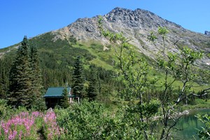
 
Cabin and vegetation a long a clear lake with mountain background.
Upper Dewey Lake cabin.

NPS photo

Upper Dewey Lake
Time: 5 - 6 hours
Distance: 6 miles (9.7 km) round trip
Rating: Strenuous
Elevation Gain: 3,100 ft. (930 m)

Getting to the trailhead: From Lower Dewey Lake go left at the junction sign, follow the trail north across several wooden footbridges to the Upper Dewey Lake trail junction sign and turn right up the trail.
Trail description: The route climbs steeply through a series of switchbacks. About 800 feet above Lower Dewey Lake there is a view of town. Near the trail’s end, the climb eases, and the route follows Dewey Creek closely for a short way. It finally emerges from the trees into a muskeg meadow, where there are views of Mt. Harding and the inlet below. A primitive cabin sits by the lake and is open to the public. Follow the trail to the left from this cabin across a spillway to a new cabin perched on the northwest end of the lake. This cabin is available for rent through the Skagway Recreation Center (907-983-2679, www.skagwayrecreation.org). Overnight campers should carry a cooking stove and not cut any live wood.

 
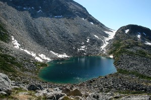
Small body of water surrounded by loose rocks and a mountain
Looking at Devil's Punchbowl from the ridge to Upper Dewey Lake.

NPS photo

Devil's Punchbowl
Time: 2 hours from Upper Dewey Lake
Distance: 2.5 miles (4 km) round trip from Upper Dewey Lake
Rating: Moderate
Elevation Gain: 600 ft. (180 m)

Getting to the trailhead and trail description: From Upper Dewey Lake, follow the narrow footpath south from the primitive cabin up the alpine ridge to a spectacular overlook. Watch for rock cairns where the trail crosses boulder fields. Devil’s Punchbowl is a tarn nestled in a deep, rocky bowl, but it is not a recommended camping spot.
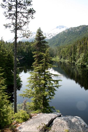
 
Mountain lake behind trees.
Arriving at Lost Lake.

NPS photo

Lost Lake
Time: 3 - 4 hours from Dyea Slide Cemetery
Distance: 2 miles (3.2 km) from Cemetery
Rating: Strenuous
Elevation Gain: 1,500 ft (500 m) Drive to Dyea.

Getting to the trailhead: Park at the Slide Cemetery and walk .8 mile (1.3 km) north to the trailhead sign.
Trail description: Follow the path toward the hillside and climb up a series of steep banks. This is a seldom-used trail, so look carefully for tree blazes and other evidence of travel. A large rock to the left provides a good view, but the trail continues upward along the gully to the right. (Ignore trails going straight up!) If it is blueberry season you will begin to notice the bushes shortly before arriving at a ridge overlooking the lake.

 
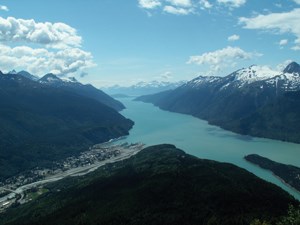
View of townsite and fjord surrounded by mountains from a mountain.
View from atop AB mountain looking down on Skagway and Lynn Canal.

Photo courtesy of K. Rain

A. B. Mountain
Time: All day
Distance: 10 miles (16 km) round trip
Rating: Difficult
Elevation Gain: 5,000 ft. (1,500 m)

Getting to the trailhead: This trail is accessible from a trailhead on the Dyea Road. Visitors without cars can hike the Smuggler's Cove trail and take the access road up to the Dyea road. From there, turn left and walk along the road a short distance until you see the trailhead across the road.
Trail description: From the trailhead, the route follows the ridgeline through spruce and hemlock forest to the base of AB Mountain. About 30 minutes into the hike, a good view of Skagway can be seen from a large rock just off the trail to the right. Beyond the stream crossing, the trail may not be clearly visible because of thick brush. Be sure to note landmarks for your return. Above tree line, some rock cairns mark the way, but the trail is easily lost on steep rocky slopes, switchbacks, and heavy brush and vegetation. Do not cross patches of ice-go around them. When you reach alpine meadows, the panoramic views are spectacular. WARNING: This trail is dangerous above tree line. Do not attempt it when weather may obscure the summit.

 
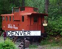
US Forest Service Denver Glacier Cabin
Denver Caboose Cabin

NPS

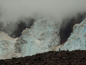
Denver Glacier
Time: All day

Distance: 4-6 miles (6-10 km) round trip from railroad stop
Rating: Moderate (difficult beyond trail end) Elevation Gain: 900 ft. (270 m)

The trail begins from the flag stop at miles 5.8 on the WP&YR railroad. From the caboose cabin, the trail parallels the south bank of the Skagway River through spruce and hemlock forest. After about two miles the trail turns south up the outwash of the glacier. The route continues south, but slippery footing and thick brush make access difficult. Winter is a good time to explore the valley on snowshoes or skis because frozen rivers are easier to cross and the brush is buried in deep snow. Avoid the area in March and April when avalanche danger is high. For information about renting the caboose, please contact the Tongass National Forest.

A note about this trail: The Denver Glacier trail is located out of town 5.8 miles up the White Pass & Yukon Route Railroad. The railroad offers flagstop service May-September; purchase tickets in advance (at depot on 2nd Ave., 1-800-343-7373, or www.wpyr.com). The U.S. Forest Service maintains cabins on both trails; call 1-877-444-6777. Both trails are used for commercially guided day hikes.

 
A person stands on rocky ground in front of a cascade of glacier ice
A hiker stands on the moraine in front of Laughton Glacier.

NPS photo

Laughton Glacier
Time: All day
Distance: 3-5 miles (5-8 km) round trip from railroad stop
Rating: Moderate (difficult beyond trail end)
Elevation Gain: 200-600 ft. (60-180 m)
Getting to the trailhead: The trail begins from the flag stop at mile 14 of the WP&YR railroad.

Trail description: The trail parallels the south bank of the river upstream to Warm Pass. After passing through a tall grass meadow the trail enters a spruce and hemlock forest where river and trail continue in close proximity to a point where the river narrows and runs through a rock cleft. Some of the small streams that are crossed have slippery logs as bridges; also, windfalls cause occasional interruptions in what is otherwise smooth traveling. The USFS cabin, which sleeps six, is located about 1,000 feet below the glacier, and about one mile from it near where the glacial outwash enters the Skagway River. The wood stove is for heating only, bring your own cook stove, and never cut living trees. For information about renting the cabin, please contact the Tongass National Forest.

Use extreme caution in venturing out on the glacier, especially during spring and summer thaws and fresh snow that may conceal crevasses.

Notes about this trail: The Laughton Glacier trail is located out of town 14 miles up the White Pass &Yukon Route Railroad. The railroad offers flagstop service May-September; purchase tickets in advance (at depot on 2nd Ave., 1-800-343-7373, or www.wpyr.com). The U.S. Forest Service maintains cabins on both trails; call 1-877-444-6777. This trail is used for commercially guided day hikes.


Hiking around Skagway

Last updated: December 20, 2019

Park footer

Contact Info

Mailing Address:

Klondike Gold Rush National Historical Park
P.O. Box 517

Skagway, AK 99840

Phone:

907 983-9200

Contact Us