|
You are viewing ARCHIVED content published online before January 20, 2025.
Please note that this content is NOT UPDATED, and links may not work. For current information,
visit https://www.nps.gov/aboutus/news/index.htm.
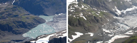
USGS photo August 6, 2005 and NPS photo August 19, 2008
Contact: Jim Ireland, (907) 224-7520 On August 19, 2008 a local sea kayak guiding company expressed concern to the National Park Service about unusually high water levels and standing waves at the mouth of Bear Glacier Lake, a popular sea kayaking destination in Resurrection Bay and Kenai Fjords National Park. Park staff flew over the Bear Glacier area that afternoon and determined that a small glacier-dammed lake had recently drained. This small unnamed lake was about 8 miles up-glacier and northwest of Bear Glacier Lake. Satellite imagery from 2005 shows that this unnamed lake previously occupied an area of about 0.17 square miles. Aerial photographs show that the glacier-dammed lake had floated a small portion of Bear Glacier prior to draining and minimum estimates of water released exceed 7,500 acre-feet. There was no evidence for flowing water on or near the surface of Bear Glacier, suggesting that the unnamed lake’s water drained through channels cut into the base or sides of the glacier. The distribution of icebergs stranded several feet above current water level in Bear Glacier Lake indicates that floodwaters are currently subsiding. Although it is likely that this small unnamed lake has drained and refilled in years before, no previous events are documented. Glacier-lake outburst floods happen when lake water stored behind, below, or inside of glaciers is rapidly released. They are not uncommon in Alaska and occur once every few years at other locations on the Kenai Peninsula (including Skilak Glacier and Snow Glacier). During glacier-lake outburst floods water discharge will increase over a period of a few days (sometimes up to two weeks) followed by a decrease to normal water levels. Outburst floods such as this can create hazardous boating conditions that might include an increase in iceberg calving at the terminus of Bear Glacier, standing waves and strong currents, or the redistribution of sediment and debris in channels like the one that exists at the outlet of Bear Glacier Lake. It is unclear if these conditions currently exist, but boaters are always advised to exercise caution in this very dynamic area. For the most up-to-date information on the status of this area, contact the parks visitor information center at 907-224-2125. As in this instance, reports of unusual conditions or events are always appreciated, and can be made to the park’s visitor information center. |
Last updated: April 14, 2015