Directions

 
An elevated view looking over Hot Springs with rolling hills, tall evergreen pine trees and blooming deciduous trees. The sun is shining and casting a glow over the valley.

NPS Photo

Physical Addresses

Hot Springs National Park Visitor Center in the Fordyce Bathhouse

369 Central Ave.
Hot Springs, AR 71901

Gulpha Gorge Campground

305 Gorge Road
Hot Springs, AR 71901


Driving Directions

 
54 miles, approx. 1 hour
  • Interstate 30 W toward Texarkana
  • Interstate 30 W to US 70 W - Hot Springs via Exit 111 (28.57 miles)

  • US 70-W (US 70 W becomes US 70 Business/East Grand Avenue) (18.65 miles)

  • Turn right onto Spring Street (Spring Street becomes Reserve Street) (4.66 miles)

  • Right turn onto Central Avenue (0.3 miles)

112 miles, approx. 2 hours
  • Interstate 30 E to AR 7 (Caddo Valley - Arkadelphia - Hot Springs) via Exit 78 (77.66 miles)
  • Turn left off the exit ramp (under the highway) to head north on AR 7/Valley Street. Valley Street becomes Central Avenue near DeGray Lake. (31 miles)

129 miles, approx. 2 hours, forty minutes

  • Head southeast on Garrison Ave/US-64 E/AR-22 toward N 8th St. (0.25 miles)

  • Take the 3rd right onto Towson Ave/US-71 Bus S. (3.68 miles)

  • Turn slight left onto Highway 71/US-71 Bus S. Continue to follow US-71 Bus S. (0.77 miles)

  • Turn slight right onto Highway 71/US-71 Bus S. Continue to follow S Highway 71 E. (39.37 miles)

  • S Highway 71 E becomes US-71 S. (16.42 miles)

  • Turn left onto Highway 270/US-270 E. Continue to follow US-270 E. (64.11 miles)

  • Stay straight to go onto Albert Pike Rd/US-270 Bus E. Continue to follow US-270 Bus E. (2.98 miles)

  • Turn left onto 3rd St/US-70 Bus E/US-270 Bus E. (0.26 miles)

  • Turn right onto W Grand Ave/US-70 Bus E/US-270 Bus E. (0.52 miles)

  • Turn left onto Central Ave/Arkansas Scenic 7 Byway/AR-7. (0.71 miles)

133 miles, approx. 3 hours

  • Head southeast on Garrison Ave/US-64 E/AR-22 toward N 8th St. (0.25 miles)

  • Take the 3rd right onto Towson Ave/US-71 Bus S. (3.68 miles)

  • Turn slight left onto Highway 71/US-71 Bus S. Continue to follow US-71 Bus S. (0.77 miles)

  • Turn slight right onto Highway 71/US-71 Bus S. Continue to follow Highway 71. (9.61 miles)

  • Turn left onto W Center St/AR-10 Spur. Continue to follow W Center St. (5.47 miles)

  • W Center St becomes AR-10. (50.76 miles)

  • Turn left onto E 8th St/AR-10. Continue to follow AR-10. (11.08 miles)

  • Turn right onto Arkansas Scenic 7 Byway/S Scenic 7 Dr/AR-10/AR-7/AR-28. (0.55 miles)

  • Turn left onto Arkansas Scenic 7 Byway/S Scenic 7 Dr/AR-7. Continue to follow AR-7. (44.06 miles)

  • Turn slight right onto Fox Pass Cutoff. (3.30 miles)

  • Turn right onto Park Ave/Arkansas Scenic 7 Byway/AR-128/AR-7. Continue to follow Arkansas Scenic 7 Byway/AR-128/AR-7. (3.26 miles)


Other Transportation Options:

Air Travel

Hot Springs is serviced by a local airport, Hot Springs Memorial Field, or Little Rock National Airport (with shuttle service and rental cars) approximately 60 miles away.

Commercial Bus

Greyhound Bus Lines service Hot Springs with a station located at 1001 Central Ave, Suite D. For fare and scheduling information, call 1-800-231-2222.

Passenger Train

Amtrak's Texas Eagle route serves Little Rock, Arkansas.
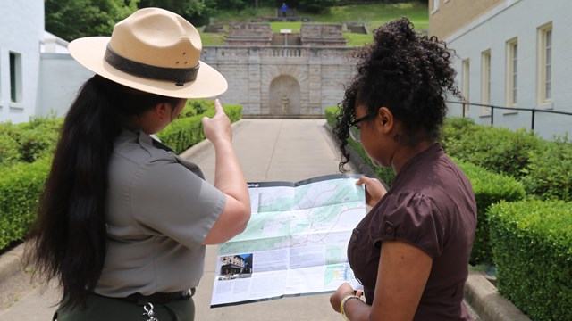
 
A park ranger uses a park map to provide a visitor with directions
Maps

Explore Bathhouse Row, scenic drives, trails, and camping in the park.

A family strolls down bathhouse row. The Fordyce Bathhouse is in the background.
Getting Around

Parking, public transportation, biking, and walking are all ways to get around the Park.


Last updated: June 11, 2020

Park footer

Contact Info

Mailing Address:

101 Reserve Street
Hot Springs, AR 71901

Phone:

501 620-6715

Contact Us