Please check Canoe Trail Conditions prior to planning your trip!
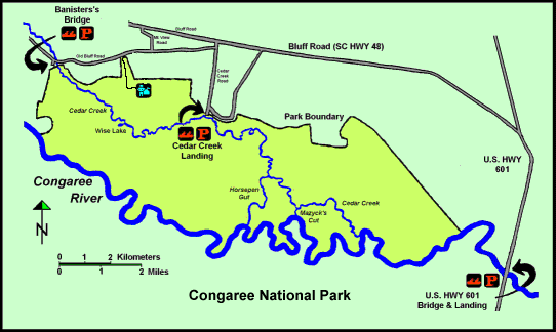
This option is ideal for canoeists or kayakers with only one vehicle. From the Cedar Creek landing, paddlers can put in and explore either upstream or downstream. This portion of the creek is beautiful and tranquil, with large bald cypress trees on either bank forming a graceful canopy over the streams dark water. Downstream from the landing is Dawson's Lake, a popular fishing spot and an excellent place to spot river otter and other wildlife. Bannister's Bridge to Cedar Creek Landing
Also a great option for canoeists with two vehicles, this trip allows paddlers to explore the wilder eastern section of the park and float down the Congaree River. As the creek winds its way towards the Congaree, it travels through some of the oldest forest remaining in the park. Here you can see immense bald cypress and towering tupelos dripping with Spanish moss. Cedar Creek makes a sharp bend to the left where Horsepen Gut enters the stream, approximately four miles from the landing. Three miles beyond this point is Mazyck's Cut, where Cedar Creek enters the river. A wooden sign post points the way and three trail markers guide paddlers to the river. Once on the river, you can make a leisurely float downstream to the Route 601 Landing. Note: This trip is best done as an overnight trip. To camp in the backcountry, you must obtain a backcountry camping permit. Backcountry camping permit requests are made by emailing cong_information@nps.gov. Requests must be made at least 72 hours in advance of a trip to guarantee processing. Requests made within 72 hours will not be considered. Congaree River Blue Trail The Congaree River Blue Trail is a collaborative effort between local, state and federal agencies, including the National Park Service, with the goal of providing access to the recreational opportunities that the Congaree River provides. The Blue Trail follows the river from its start in the city of Columbia to the Route 601 Landing near the confluence of the Congaree and Wateree, and travels past diverse habitats, offering paddlers the opportunity to see bald eagles, alligators and a variety of other wildlife. This is a trip that is best spaced out over two or three days. Canoes or kayaks can be launched at one of several landings in the city of Columbia. There are no designated campsites along the river, but paddlers can use the sandbars that are available during times of low water, or backcountry camp when the reach Congaree National Park near River Mile 26. A backcountry permit is required to camp in Congaree, and can be obtained by emailing cong_information@nps.gov. Paddlers should be aware of the backcountry rules and regulations before stopping for the night. Please carry plenty of water, as it is not advisable to drink any water out of the Congaree River. If you would like to check out the route, you can find the Blue Trail map on the All American Rivers website . There are also waterproof copies available at the Harry Hampton Visitor Center. |
Last updated: November 1, 2024