Protection zones for nesting birds and sea turtles are seasonal or temporary area closures to motor vehicles with the exception of the following permanent closure areas:
A Cape Lookout Beach Access Status Map is available for seeing which ramps and beach areas are open for vehicle usage. Please note: Signage in the field has the "final say". The closures on the beach represent the most current beach access status, and should be considered more accurate than this map. 
NPS Photo/S.Godin Know Before You GoBefore heading to Cape Lookout National Seashore, familiarize yourself with our wildlife protection signs. Wildlife signs are seasonal or temporary depending on the wildlife activity. If you are unsure of what a sign means, stop and read it before you proceed. Below is a gallery of signs you may see posted while visiting Cape Lookout National Seashore. Wildlife Protection Zone Frequently Asked Questions Temporary protection zones are put into place to protect a variety of nesting colonial shore birds as well as sea turtle nests. The park is required under the Federal Endangered Species Act and the Federal Migratory Bird Act to protect these species. A wildlife protection zone protects these endangered species while still allowing people to drive on most of the beach.
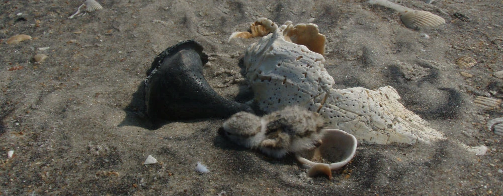
Human activity can cause adult birds to abandon their nests. In addition, the nests of shore birds are very difficult to see and avoid and when young chicks are threatened, they hide by staying perfectly still and blending in with the sand. Closing an area to humans and vehicles prevents nest abandonment, the eggs from being crushed in the nest, or young chicks from being run over. Find more information on the Piping Plover webpage. Read about the American Oystercatcher under the protected species page. Driving on the beach creates deep tire ruts in the sand. A sea turtle hatchling is very small and may become trapped in a tire rut as they head down the beach towards the ocean. Sea turtle hatchlings unable to get out of the tire rut will die from predation or dehydration. Protection zones are put up approximately ten days before the nests are expected to hatch so that the beach can smooth out naturally.
Protection zones for bird nesting occur from April to August. Protection zones for sea turtle nesting occur from July to October. A bird protection zone area is selected based on where the birds are nesting, how many nesting pairs are in the area, and the age and activity of the chicks. Turtle protection zone areas are selected based on where the turtles nest. Park staff work to restrict access to as small an area and for as short a period of time as is absolutely critical for the protection of the nests, young chicks, and turtle hatchlings.
Bird protection zones are in place from the time that nesting begins until the chicks are able to fly. It takes 25-35 days from the time the eggs are laid for them to hatch. Once the eggs hatch it will take around another 30 days until the chicks are able to fly. Turtle protection zones stay up for ten to fifteen days, depending on when the eggs hatch.
Nesting areas are often on the upper beach out of the way of vehicle traffic. Once the eggs have hatched, the young chicks wander away from the nesting area looking for food along the sound or ocean beach, or near tide pools. At this time protection zones may need to be expanded to allow them to safely feed until they are old enough to fly. To keep turtle hatchlings from getting stuck in tire ruts, a protection zone is established on the beach in front of a turtle nest shortly before the nest is due to hatch. Vehicle traffic is only affected in those areas where the chicks are feeding along the ocean beach or where turtle nests are within two weeks of hatching. The signs marking the protection zone will specify if you can walk through or if it is closed to all entry. Be sure to read and follow the sign directions! For more information on beach signs, view the photo gallery above.
Annual reports for bird counts, nesting success, endangered plant species, and Shackleford horses can be found on the publication page.
|
Last updated: July 31, 2025
