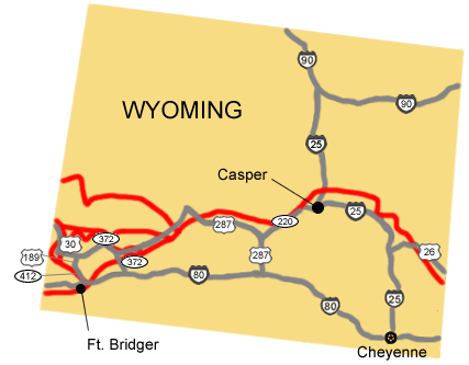
To Utah:
1. Take U.S. Route 26 west to Interstate 25.
2. Turn north onto Interstate 25.
3. Take Interstate 25 west to State Route 220 at Casper.
4. Turn west onto State Route 220.
5. Take State Route 220 to U.S. Route 287.
6. Turn west onto U.S. Route 287.
7. Take U.S. Route 287 west to State Route 28.
8. Turn West onto State Route 28.
9. Take State Route 28 west to State Route 372.
10. Turn south onto State Route 372.
11. Take State Route 372 to Interstate 80.
12. Turn west onto Interstate 80 to the Utah border.
Northern Route to Idaho:
1. Take U.S. Route 26 west to Interstate 25.
2. Turn north onto Interstate 25.
3. Take Interstate 25 west to State Route 220.
4. Turn west onto State Route 220.
5. Take State Route 220 to U.S. Route 287.
6. Turn west onto U.S. Route 287.
7. Take U.S. Route 287 west to State Route 28.
8. Turn West onto State Route 28.
9. Take State Route 28 west to State Route 372.
10. Turn west onto 372.
11. Take State Route 372 west to U.S. Route 189.
12. Turn south onto U.S. Route 189 to U.S. Route 30.
13. Turn west on U.S. 30 towards Montpelier, ID.
Route through Ft. Bridger to Idaho:
1. Take U.S. Route 26 west to Interstate 25.
2. Turn north onto Interstate 25.
3. Take Interstate 25 west to State Route 220.
4. Turn west onto State Route 220.
5. Take State Route 220 to U.S. Route 287.
6. Turn west onto U.S. Route 287.
7. Take U.S. Route 287 west to State Route 28.
8. Turn southwest onto State Route 28.
9. Take SR 28 west to State Route 372.
10. Turn southeast onto State Route 372.
11. Take State Route 372 South to Interstate 80.
12. Turn west onto Interstate 80.
13. Take Interstate 80 west to State Route 412.
14. Turn South to Ft. Bridger, then back north onto SR 412.
15. Take SR 412 North to U.S. Route 189.
16. Turn north onto U.S. Route 189.
17. Take U.S. Route 189 north to U.S. Route 30.
18. Turn west onto U.S. Route 30 toward Montpelier, ID.
Total original route miles in Wyoming (including alternate routes): 1,088.