 and shale (bottom) rock layers, as seen from NM County Road 2900.")
Nicoletta Browne, NPS. IntroductionThe environment that the ancestral Pueblo people lived in heavily influenced their culture. In the San Juan Basin, the presence of particular animals, such as wild deer and domesticated turkeys, or plants, such as yucca and juniper, determined what they ate, what they used to make tools, what they made clothes out of, and so on. Although the people living at what is now Aztec Ruins National Monument traded for items that were not locally available, they were still most heavily dependent on and influenced by the ecosystem they were living in. The same, too, can be said about the landscape itself, from the rocks and minerals present in the area to the soil. The geology of the San Juan Basin heavily influenced ancestral Pueblo culture, as did that of surrounding areas where people went to obtain materials or, in some cases, which were (and still are) the source of materials brought by the Animas River.A Brief Overview of Geologic TermsGeology is the study of rocks and the physical processes of the Earth, while paleontology, which is inextricably tied to it, is the study of ancient life. Rocks come in three varieties: igneous, sedimentary, and metamorphic. All three types are represented in the San Juan Basin, although the sedimentary rocks are most common.Igneous rocks form from magma that either cools underground or erupts at the surface as a volcano. Most of the Earth's crust is fundamentally made of igneous rock, but much of it is buried. On the surface, wind, water, plants, and other processes will contribute to the breakdown (erosion) of rock into physical particles and chemicals, collectively known as sediment. When sediment, sometimes along with dead organisms, is compressed and hardened over geologic time, it becomes sedimentary rock. If the dead organisms are preserved, they are known as fossils. A third type of rock, metamorphic, occurs when pre-existing rock, either igneous, sedimentary, or a different metamorphic rock, is fundamentally changed in regards to its mineral content and structure. Via the rock cycle, it is possible for any one of these three rock types to, eventually, be converted into the others. Our understanding of the past relies on all three rock types. Sedimentary rocks form from sand, mud, oozes, and other materials that often contain fossils, and studying them also tells us what sort of environment existed here in the past. At Chaco Culture, for example, ripple marks, shrimp burrows, and clam fossils in the sandstone cliff walls indicate that the sand that formed the sandstone was initially deposited in a beach environment, a very different environment than today's landlocked desert. While igneous and metamorphic rocks rarely contain recognizable fossils, they often contain minerals that contain trace amounts of uranium and other radioactive isotopes. This allows geologists to determine (within limits) the age that, for example, a lava flow cooled or a layer of rock was metamorphosed. 
Nicoletta Browne, NPS 
Nicoletta Browne, NPS Geology of the San Juan BasinThe northeast corner of New Mexico, including Aztec, consists of the San Juan Basin (named after the river of the same name), which is part of the Colorado Plateau geomorphic province. This province also covers southwestern Colorado and large portions of Arizona and Utah. Unlike most of the rest of New Mexico, but like all of the Colorado Plateau, rivers in the San Juan Basin drain to the Colorado River and ultimately to the Pacific Ocean, since they are on the western side of the Continental Divide.The rocks of the Colorado Plateau range from being billions of years old to only a few tens of millions of years old, although not all of these layers are visible in the San Juan Basin. Compared to surrounding areas, such as the heavily deformed rocks of the "Basin and Range" province that covers much of Nevada and Utah, the rocks of the Colorado plateau are relatively horizontal and far less warped, making them easier to study. The oldest rocks are igneous rocks like granite and metamorphic rocks like gneiss, schist, and quartzsite that are normally only exposed where uplift and subsequent erosion by rivers have exposed them. Although not normally visible in northeastern New Mexico, rivers entering the state from Colorado cut down deep enough in the San Juan Mountains to expose these rocks and carry pieces of them with their flow, depositing them as the rivers start to slow down when they leave the mountains. Most of the rocks visible near Aztec Ruins are sedimentary rocks from the Mesozoic, The Age of Dinosaurs, and the more recent (and current) Cenozoic, known as The Age of Mammals. Along the Arizona border, minor warping results in the rocks from before the Mesozoic plunging downwards and not being visible in New Mexico; this also causes the elevation of this area to be fairly low, creating a river valley. The edges of the San Juan Basin are rimmed with sandstone and shale from the Mesozoic Era, originating from beach and continental shelf deposits, respectively, that indicate the presence of an ocean. During the Cretaceous Period, the lack of ice at the poles led to a higher sea level that flooded much of what is now the central United States, with Northeastern New Mexico being along the edge of that interior seaway. The center of the basin consists of more-or-less horizontal layers of Cenozoic Era sediment. The Cenozoic Era also saw the uplift of the Rocky Mountains, which caused volcanism along the western fringes of the basin; Shiprock, a volcanic neck sacred to the Navajo and other indigenous peoples who have lived in the area, originated during this time. Shiprock is a volcanic neck: the magma inside of a volcano cools into a durable rock, and when the surrounding, softer rock erodes away, the neck is left behind, with horizontal ridges of lava rock or "dikes" emanating from the center where veins of lava existed. Today, the San Juan Basin is noted for oil and gas production. Most of the fossil fuels in this area occur in a series of rocks known as the Mesaverde group, which originates from the Cretaceous Period, the last period of the age of dinosaurs, when much of this area was either underwater or along the shoreline of the interior seaway. Oil and gas form when the remains of marine phytoplankton, single-celled photosynthetic organisms that live in seawater, accumulate on the seafloor and are buried and altered by geologic pressure before they can decay. The overlying rock layers from the age of mammals pressurize the oil and gas, meaning that when wells are drilled, pumping is not normally required. 
Nicoletta Browne, NPS 
Nicoletta Browne, NPS 
Andrew Kearns, NPS 
Nicoletta Browne, NPS Building a Pueblo: The Rocks of the Aztec West Great HouseAztec West, the great house accessible to visitors, was built in the 12th century AD as an "outlier" of Chaco, essentially a satellite city. The ancestral Pueblo people built the main complex out of lumber harvested from what is now southern Colorado as well as several types of stone, most of which are common in this area but some of which also came from Colorado. Particularly in arid regions, stone buildings are fairly durable, explaining in part why buildings such as the Pyramids and Great Sphinx of Giza still stand after thousands of years. Although some rocks are more durable than others, all will erode to some extent when exposed to wind and water; like the Great Sphinx, the great houses at Aztec and Chaco were better-preserved when covered by soil, and they have required modern restoration and preservation efforts to combat the effects of erosion. This is one of several reasons why Aztec East, Aztec North, and several other sites identified within the monument remain unexcavated.The ancestral Pueblo people built most of Aztec West out of sandstone bricks. This was partially out of intent to emulate construction styles at Chaco, where the cliffs of the canyon are composed of a marine Cretaceous sandstone that is well-consolidated, making it especially durable, but also fairly easy to break and shape into slats and bricks. Sandstone is also common in the Aztec area, and the bricks here were quarried from sandstone deposits, also of marine origin but from the more recent Age of Mammals, that are visible as one drives on the roads heading north towards the Colorado border. In general, since it is porous and permeable and allows water to pass through it before it becomes stuck and begins to cause damage, sandstone is a durable building material; as a contrasting example, shale or "mudstone" from ocean and lake mud deposits tends to be impermeable, and water causes them to crumble much more quickly, producing the slopes characteristic of "badlands." The sandstone here, however, is more crumbly and less durable than that found at Chaco, and was thus somewhat harder to work with. In some areas of the great house, cobblestones from the Animas River were used instead of sandstone. These cobblestones consist of pieces broken off from rocks along the course of the Animas River, which include granite, schist, and gneiss that, in some cases, are as old as the Proterozoic Era, hundreds of millions of years old and from a time before most complex life had evolved. Uplifted by mountain building, eroded by the river, and then deposited along its banks as it slows, these cobblestones largely consist of rock types that are harder than sandstone, and since they had no metal tools, the ancestral Pueblo people would fashion axes, hammers, and other tools out of these rocks that they would use to quarry and shape the sandstone bricks. In some cases, they would also use these cobblestones as a building material: they were closer to the city than the sandstone deposits, and did not require shaping. Since round cobblestones do not stack well, builders would set them in a large amount of clay mortar. Some archaeologists have proposed that the cobblestone segments date from the later stages of occupation during the 13th century, by which time the Chacoan system had collapsed and the political will to emulate Chacoan construction would have been diminished. This is true in some cases, but some older wall segments also have cobblestones, indicating that, on ocassion, they may simply have been used as a substitute material, or possibly as a a quicker and easier material for repairs. Cobblestones were also used to help support the foundations of the buildings, and so from the beginning, ancestral Pueblo engineers were aware of their usefulness: they dug ditches on the intended sites for walls, and filled them with cobblestones and infill dirt to provide more stability than they would get from simply building on loose soil. Like most of the complex, the Great Kiva was built largely out of sandstone bricks, and this includes the four columns holding up its roof. Pueblo engineers went to great lengths to ensure the stability of these columns. At the base of each column was a stack of discs made from limestone, with lignite (a soft grade of coal) used to hold them together. Limestone, like sandstone, is a sedimentary rock, but one formed from chemicals dissolved in water rather than physical pieces of rock. Frequently, limestone forms on ocean flats devoid of sand and mud, far from shore, where over time, the dead bodies of phytoplankton (the same organisms that oil originates from) accumulate on the seafloor. Many of these phyotoplankton have cell walls made of calcium carbonate, the same compound found in clam shells, coral, and the shells of many water-dwelling organisms. Over time, an ooze forms out of these millions of tiny shells, which form into limestone when put under geologic pressure; less commonly, limestone can form from the accumulation of coral or seashells as well. The limestone used in these discs formed in an ocean that predates the dinosaur era, and the rocks that originally formed in this ocean were uplifted and shaped into mountains during the formation of the Rocky Mountains. Limestone is sometimes found near Aztec, but the most widespread and best-quality deposits within the Chacoan world were those in the Colorado mountains, and so just as they did with the ponderosa pine trees, the inhabitants of Aztec went quite far out of their way to obtain good building materials for the Great House, and the Great Kiva in particular. Limestone, unless exposed to acid (which causes fizzing, a good field test), is fairly durable and also denser and easier to shape than the sandstone. The rock was quarried, shaped into discs that the entire column could comfortably fit on, and flattened, providing more stability for the columns and the roof that unconsolidated soil would have. The presence of one final rock in the walls is something of a mystery. Along the western side of Aztec West, and only along this side, some of the rooms and parts of the outer wall have stripes of a dark-green rock called greywacke taking the place of some of the sandstone pieces. Greywacke is, in fact, a special variety of sandstone: it is a "dirty" sandstone, with a higher-than-usual percentage of mud and volcanic rock fragments mixed in, that forms during underwater avalanches or "turbidity currents" like the ones that sometimes occur off the West Coast of North America today. These events are uncommon, and thus greywacke deposits are also rare. In the San Juan Basin, only a few hills containing greywacke exist, with one being three or four miles from the present site of Aztec West. Neither archaeological evidence nor Puebloan oral histories give a clear idea as to what the purpose of these greywacke stripes was. For one thing, they would have been covered with a mud plaster, just like all of the walls, meaning that they would not have been visible when people lived here. The same pattern occurs at Salmon Ruin, a roughly contemporaneous Chacoan Outlier along the San Juan River, but is not documented from Chaco, Aztec East, or other Chacoan outliers. The stripes likely have some connection to water, agriculture, astronomy, or perhaps a combination of those, since the placement of walls, windows, and other features at Aztec West was so heavily influenced by solar or lunar events (such as the north wall lining up with the summer solstice sunrise), and these events were used as a "calendar" to determine, among other things, the timing of crop planting. 
Nicoletta Browne, NPS 
Nicoletta Browne, NPS Rocks and Minerals in Spiritual and Everyday Life at Aztec WestThe ancestral Pueblo people used rocks, minerals, and clay for a wide variety of purposes besides building. Just like the sandstone, some of these were present nearby, while for others people would either travel or trade to obtain them."Clay" refers to fragments of rock that are fine-grained (far smaller than sand particles) and rich in clay minerals, aluminum-based minerals that form in the presence of water. When wet, clay has a plastic, malleable texture and can be shaped into pottery. Firing the pottery has the effect of drying and hardening the clay, but the high temperatures used by potters cause the minerals to recrystallize and fuse, which makes the finished product far stronger than clay that slowly dries in the sun. The clay content of the soils around Aztec has multiple consequences, such as making the area suitable for agriculture but also somewhat prone to flooding (since clay soils do not drain well), but the clay also enabled artisans to make a great deal of beautiful and high-quality pottery, namely the light-colored vessels that were painted with black dyes to produce the classic "black-on-white" style. The same cobblestones used to make tools and as a building material were also used as manos, the round, hand-held stone used to grind corn, while the stone troughs used for this process (metates) along with flat cooking stones were made of limestone or sandstone. Hematite, the mineralogical name for "rust", was gathered nearby and used to make pigments, beads, and paint sticks, while locally available selenite and other forms of gypsum were used to make jewelry. 
Nicoletta Browne, NPS 
Nicoletta Browne, NPS 
Nicoletta Browne, NPS. 
Nicoletta Browne, NPS Dating the Rocks: Radiometric Dating and FossilsThe construction dates of Aztec West and other great houses found throughout the American Southwest were determined by tree-ring dating or dendrochronology. For rocks, geologists have to use a variety of techniques to determine their ages, and it is not always possible to assign an exact date. Different practices are used to place metamorphic and igneous rocks in time than are used for sedimentary rocks, but sedimentary rocks often have the most useful information about what sort of environment existed at the time of formation, and so having more than just one category of rock provides a more complete picture for geologists and paleontologists.Igneous rocks, and to a lesser extent metamorphic rocks, can be studied using a technique called radiometric dating. The minerals in igneous rocks form when the magma cools, and some of these minerals, like zircon and titanite, contain trace amounts of uranium or other radioactive isotopes (varieties) of elements. A radioactive isotope is unstable and will break down at a regular rate; uranium, for example, decomposes to lead over time, and since the breakdown is regular, scientists can make calculations using the amount of leftover uranium compared to the amount of lead formed by decay. A number of variables go into this, including the hardness and chemical reactivity of the given minerals, but in short, a high-quality sample of granite or another igneous rock can yield minerals whose chemical content can be used to determine the age at which that rock formed. The same process can be used for metamorphic rocks, though it is usually even more complicated; if a scientist is sure that a mineral formed during the process of metamorphism, a radiometric date obtained from this rock will tell when the rock was changed from one rock into another. Radiometric dates from the granites, schists, and other rocks making up the river cobbles in the Animas River, along with their source rock, are how we have determined that these are some of the oldest rocks on earth. Throughout much of the San Juan Basin, there are few igneous or metamorphic rocks, with only a few scattered volcanic features like Shiprock cutting across the sandstones and other sedimentary rocks. A radiometric date on Shiprock or a volcanic dike that cuts across sedimentary layers can tell us the age of the volcanic rock and that the sedimentary layers are older. However, it is nearly impossible to obtain absolute dates from sedimentary rocks since they are composed of parts of other rocks, and radiometric dates from the minerals don't actually indicate when the rock was compressed. The ages of sedimentary rocks can be determined in a relative manner by comparing them to the placements of igneous rocks (such as lava flows or layers of ash) as well as one another, which can give age ranges and estimates. An especially powerful tool that helps with this is the presence of fossils. For one thing, fossils give scientists clues as to what type of environment rocks formed in, and how the earth has changed since then. The four corners region, for example, is full of petrified wood from the Triassic Period (the first period of the dinosaur age) that indicates that what is now desert was once a verdant conifer forest. The presence of seashells in sandstone, likewise, indicates that the sandstone formed on a beach and not in a desert. Some fossils are common but only occur during a relatively narrow time frame, and the presence of these "index fossils" can indicate when a rock was deposited. Much of this work is done through careful study of minor variations in clams, trilobites (extinct arthropods), corals, and other common species, but on the rare occasions that fossils of dinosaur, mammals, or other larger, more charismatic animals are found, they can be a dead giveaway as to whether a rock is from the Cenozoic, Mesozoic, or before. How do we know that the sandstones in this area are from the Age of Dinosaurs? Aside from a few radiometric dates of nearby rocks and careful study of the layering and index fossils, we have some dinosaur fossils from the area! Bistahieversor, an early relative of Tyrannosaurus, was found in and named after the Bisti wilderness, an area just south of here, while rocks near Moab, Utah that also crop out in this area have produced Utahraptor, a larger and earlier relative of the more famous Velociraptor. While the ancestral Pueblo people did not have access to radiometric dating or other modern scientific equipment, they certainly would have had plenty of scientific observations about the geology and fossils of the area. They may not have been able to tell exactly when these ancient stones were formed, but they could certainly tell the difference between different types of rock and mineral, in regards to properties like their hardness, density, and color, and appropriate uses for each type. They also likely would have observed oddities like the presence of seashells, items that they mainly knew from trade, in an area that is now hundreds of miles from any ocean. Pueblo people may have even come across fossils of dinosaurs or other extinct animals, and wondered, just as we do today, about the worlds these mysterious creatures had once lived in. 
Image courtesy of the Bureau of Land Management; fossil in the collection of the New Mexico Museum of Natural History and Science. 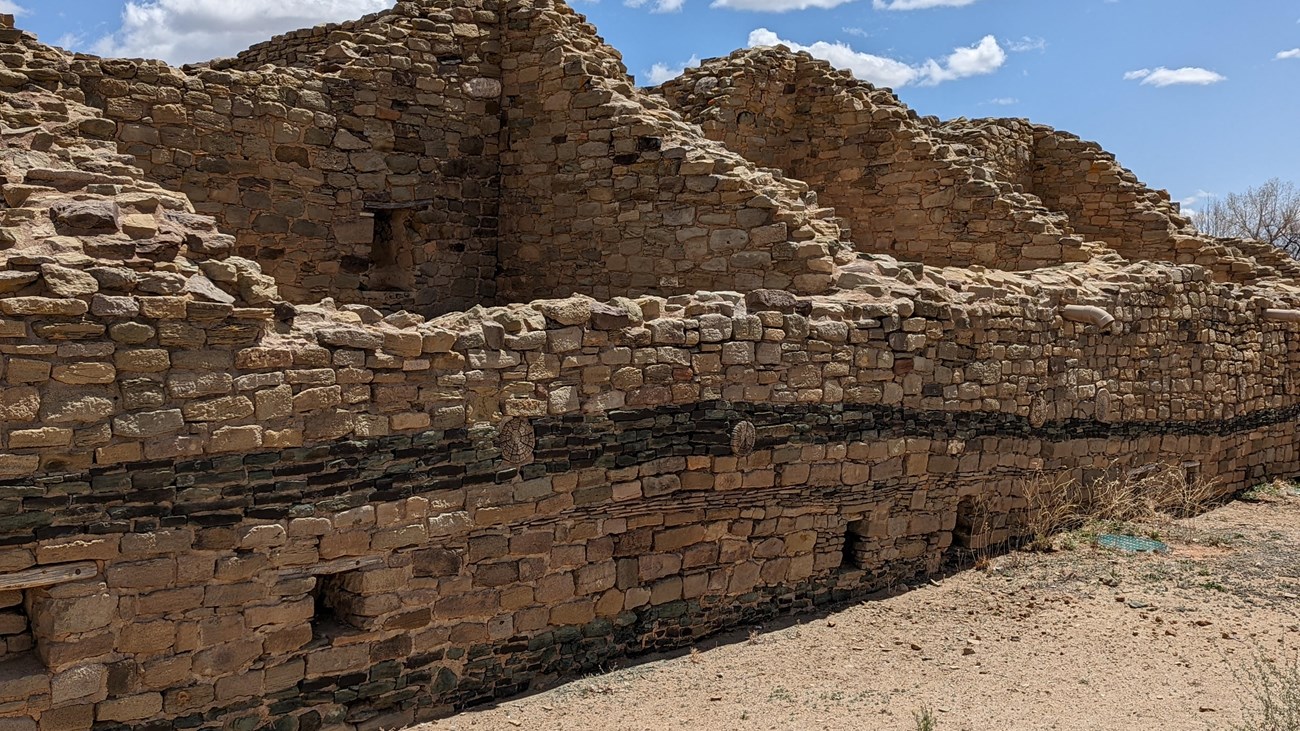
NPS Geodiversity Atlas - Aztec Ruins NM
Learn more about the Geodiversity at Aztec Ruins National Monument! |
Last updated: April 8, 2023