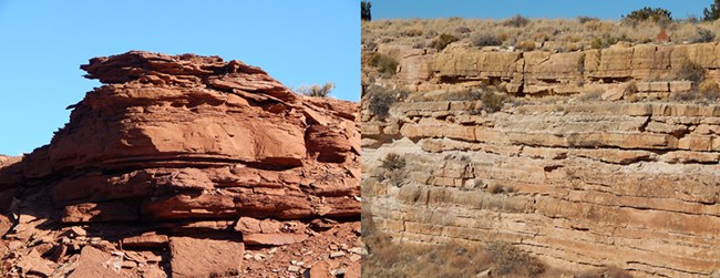
NPS photo by Dallas Larsen. Geology Of WupatkiTraveling through the four corners states is like jumping into a time machine and going through millions of years of geologic time. Some of the oldest rocks are at the bottom of the Grand Canyon but most of the geology in Wupatki consists of sedimentary rocks from the Permian and Early to Middle Traissic. An Uplifting ExperienceAbout 80 million years ago, near the Pacific coast, two large pieces of the earth's crust were colliding. The resulting compressive forces caused the western edge of North America to fold and buckle. This compression caused the Colorado Plateau to slowly inch upward, eventually reaching over a mile in height. Though many of the rock layers on the plateau remained level, great folds and faults formed in the process; the Doney fault and Black Point monocline in Wupatki are examples of such features. With the plateau's mass of marine and coastal rocks now exposed to weathering by rain, river and wind, the magnificent canyons and sculptured rock formations characteristic of the Plateau began to develop. Then about 40 million years ago, compression and uplifting ceased. However, the slow, imperceptible erosional processes are still at work today wearing down mesa tops and deepening the canyons. Uplift and buckling of the Colorado Plateau resulted in fracturing of the local rock layers. Life Among the RocksUsing the help of rocks deposited by water, fractured by great uplifts, and erupted out of volcanoes, the people here carved a life out of the desert. Because of fractures formed during uplift, the sandstone and limestone break naturally along flat edges, making great building blocks. Clay formed from the erosion of rocks was used for mortar to hold walls together. Chert found in the river gravel deposits was knapped into arrow points and cutting tools. What did the ancestral puebloans think of the occasional pyrotechnics? Some people speculate the black cinders acted as a valuable moisture-holding mulch for crops and may have influenced people to move to the Wupatki area around AD 1100. Blowholes are also important. Stories among the Hopi refer to these openings as the source of the wind and the home of the wind god, Yaponcha. Wind is significant to farming for it can create clouds which bring needed rain. Many large pueblo sites in northern Arizona, including Wupatki Pueblo, are located near blowholes. Rocks are no less important to people today. Buildings are built from rock, and icy roads are made safer with cinders and sand. Flakes of volcanic glass (obsidian), sharper than steel blades, are used for eye and heart surgery. The list is long. Think of how your day is made better by rocks...perhaps you'll be surprised. Where can these rocks be seen?You will see many of the layers within the Moenkopi formation throughout the southeastern areas of the monument. Since most of the pueblo walls are built with these naturally straight ‘bricks’ you can easily view them while also absorbing the dynamic human history. Prominent in-situ sandstone and shale outcrops can be seen along the Wupakti and Wukoki pueblo trails. 
Blowholes and Earth CracksWupatki National Monument is home to a surprising phenomenon where air blows directly out of the ground beneath your feet. At the end of the Wupatki Pueblo trail is one of several ‘blow holes’ where visitors can experience what some have called the ‘breathing earth’. The blowhole crack system has not been fully explored or mapped because it is too narrow for human passage but, by measuring the amount of air blowing out of the holes, scientists estimate it to be 7 billion cubic feet of air space. That’s enough air to fill about 84 thousand hot air balloons! Archeologists are unsure what the ancestral Puebloan residents of Wupatki thought of this natural wonder. No structures were built around the hole near Wupatki Pueblo during that time. |
Last updated: August 6, 2024
