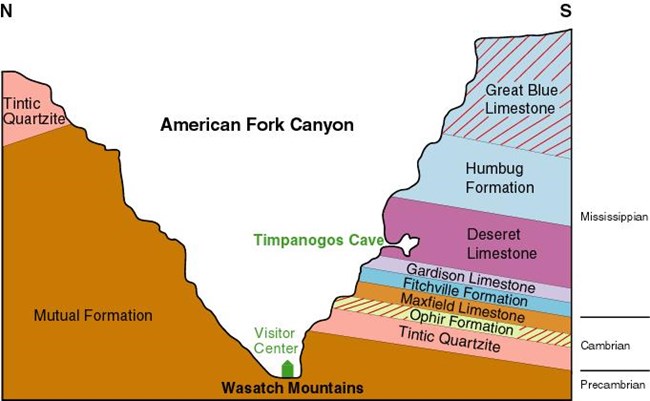
Timpanogos Cave National Monument resides at the boundary between the Rocky Mountains and the Great Basin. These are two of the huge physiographic provinces that make up the American West. Locally, the Wasatch Range is the westernmost expression of the Rocky Mtns, while Utah Valley is the beginning of the Great Basin. Both the Wasatch Mountains and the Great Basin are relatively new landforms, geologically speaking, and are still developing today.
Deposition of Deseret Limestone 340 myaDuring the Mississippian Period, Utah was near the equator and mostly covered with a warm, shallow sea. Out in the ocean basin, away from terriginous (land-derived) sediments, conditions were perfect for the deposition of calcium carbonate, the main ingredient of limestone. Rock Layers along the Cave TrailThe layers you hike past as you climb to the caves are, in sequence from the bottom:

NPS / A. Shirey Window Into the PastMuch of the early geologic history of Utah is exposed within the rocks of Timpanogos Cave National Monument. Along the trail you will see seven types of rocks that were deposited in shallow seas 600 million to 340 million years ago. These shallow seas existed at sea level near the equator. After the deposits were turned to rock, they rode on a continental plate to their current location and then were uplifted to their present elevation. Deseret Limestone - As the sea continued to advance to the east about 340 million years ago, this limestone was deposited at the bottom of an ever deepening sea. Mostly broken pieces of fossils are found here, however solitary horn corals and colonial corals are locally common. This formation is 400-feet thick, is composed mostly of dolomite with some limestone, has numerous nodules and lenses of tan to black chert, and has a unit of shale near the base.
|
Last updated: April 23, 2025
