Last updated: November 9, 2022
Thing to Do
Tree Scavenger Hunt in the Ohanapecosh Campground
NPS/C. Raven Photos
Use the provided tree identification key to see if you can identify the different types of trees within the Ohanapecosh Campground. Three tree species, western hemlock, Douglas-fir, and western red cedar, are the most abundant. See if you can tell them apart using their identifying factors listed below. This is a fun educational activity to do on your own, with a partner, with friends, or with family. The knowledge gleaned from this activity can be used in many places where these trees are found other than in Mount Rainier National Park.
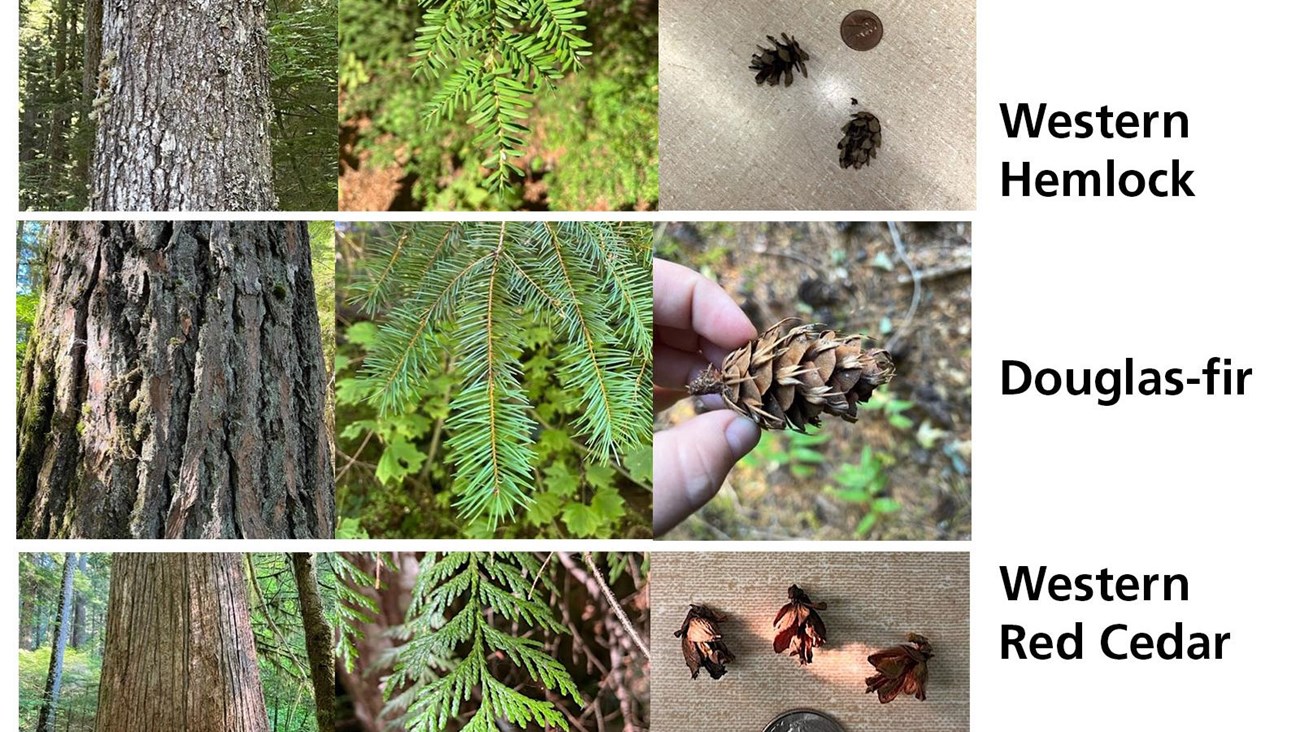
Western Hemlock (Tsuga heterophylla)
- Smaller than Douglas-fir
- Needles:
- Very short
- Distinctly different sizes along the same twig
- Yellow-green on top
- Two white bands running along their undersides
- Tend to stick out on the sides of the twig, but can occur on top of the twig
- Cones:
- Egg shaped
- 1 inch long (small)
- Bark:
- Thin
- Furrowed
- Brown
Douglas-fir (Pseudotsuga menziesii)
- The tallest tree in Mount Rainier National Park. This tree typically has higher growing branches meaning that the lower 1/2 to 1/3 of the tree will be devoid of branches. Other tree species will have branches that are within eye level. The reason for their higher growing branches is due to the fact that a Douglas-fir will self-prune, an adaptation to conserve energy.
- Needles:
- Blunt
- 1” long
- Green on top
- 2 white bands underneath
- Cones:
- Woody
- Paper thin 3 pointed bract that protrudes downwards underneath the woody scales
- Young cones can be crimson or yellow
- Bark (Mature Trees):
- Reddish brown
- Deeply grooved
- Thick
- Bark (Young Trees):
- Gray
- Thin
- Smooth with resin blisters
Western Red Cedar (Thuja plicata)
- Most distinctive markers of this tree are its bark and needles.
- Needles:
- Scale like
- Tightly bunched along twig
- Green on top
- White butterfly pattern underneath
- Cones:
- Small (½” long )
- Woody
- Grow upright on twig
- Have a rose bud shape
- Bark:
- Thin
- Reddish-brown
- Stringy
Learn more about the Trees of Mount Rainier.
Details
Duration
30-60 Minutes
This activity can be modified to fit any time constraints.
Activity
Self-Guided Tours - Walking
Take a self-guided walk and see if you can identify the trees you are looking at. This self-guided walk can take place within the campground or on one of the trails. This can be modified as a walk or a hike. While you are looking at the trees, see if you can spot any wildlife such as Douglas squirrels, pileated woodpeckers, chipmunks, Stellars jays, or any other wildlife that lives among the trees.
Age(s)
Suitable for all ages.
Pets Allowed
Yes with Restrictions
Pets are allowed within the campground (at a campsite if you have one), but must remain on paved roads otherwise and are not allowed on any trails. Pets must be on a leash.
Activity Fee
Yes
Park entrance fee required.
Location
Ohanapecosh Campground.
The Ohanpecosh Campground is located in the southeast corner of the park and is located 2 miles (3.2 km) south of the Stevens Canyon Entrance or 1.5 miles (2.4 km) north of the south east park boundary.
Reservations
No
Season
Spring, Summer, Fall
The Ohanapecosh area is typically open late spring through early fall, depending on weather.
Time of Day
Day
This activity should be done during daylight hours for better visibility of trees.
Accessibility Information
This activity can be done in the campground on paved roads. Note that pets are allowed on the campground loop roads, but are not allowed on any trails (service animals excepted).
This activity can be done on the Silver Falls Trail. This is a loop trail that is 2.7 miles, has about 300' elevation gain and change, can be slippery and steep in some areas, has a bridge crossing, alternates between narrow and wide trail width, and has uneven rocky and muddy terrain along some areas.
This activity can be done on the Ohanapecosh Hot Springs Nature Trail. This is a loop trail that is about 0.4 mile long and has less than 100' of elevation gain. This trail alters between narrow and wide width, can be slippery, muddy and has uneven and steep terrain along some areas.
There are restrooms located outside the visitor center, as well as in each of the campground loops.