Last updated: December 15, 2022
Thing to Do
Places To See in One Hour
If you only have an hour to visit Pictured Rocks, here is a list of popular spots you can get to quickly, depending which end of the park you are on. Be aware that just driving from one end of the park to the other already takes more than an hour. If you have a boat tour scheduled in Munising, give yourself extra time to get there.
COMING FROM MUNISING: (west side of the park)
Munising Falls / Sand Point
Both Munising Falls and the beaches of Sand Point can be enjoyed in an hour. Head east out of Munising on Alger County Road H-58 about 1 mile and turn left on Washington Street. (Watch for road signs to Munising Falls and Sand Point.)
The Munising Falls parking lot is across from the hospital at the junction of Washington Street and Sand Point Road. Walk the paved 800-ft. trail to Munising Falls. Leashed pets allowed.
Afterwards, drive 2 more miles down Sand Point Road to the beaches at the end. Enjoy stunning views of Grand Island across the bay. Both Munising Falls and Sand Point have plowed roads and parking lots that can be accessed by regular vehicles in winter. Leashed pets allowed.
Sand Point / Sand Point Marsh Trail
You can easily spend an hour at Sand Point walking the beach and also exploring the 1/2 mile boardwalk Sand Point Marsh Trail through some of the park's most beautiful wetlands. See directions to Sand Point above.
The wheelchair-accessible marsh trail loop begins at the main Sand Point Beach parking lot. This trail is great for kids, bird watchers, and all nature lovers. Pets are not allowed on the Sand Point Marsh Trail.
Miners Falls
The parking lot for the Miners Falls Trail is approximately 9 miles from Munising. Follow Alger County Road H-58 about 5 miles east to Miners Castle Road (H-11). Turn left and go 4 miles north to the turn-off for Miners Falls. Turn right and drive 1/2 mile on the unpaved road to the parking lot.
From the parking lot, the trail is 1.2 miles roundtrip. The gently rolling trail goes through a beautiful northwoods forest, ending at two viewing platforms for Miners Falls. Leashed pets allowed.
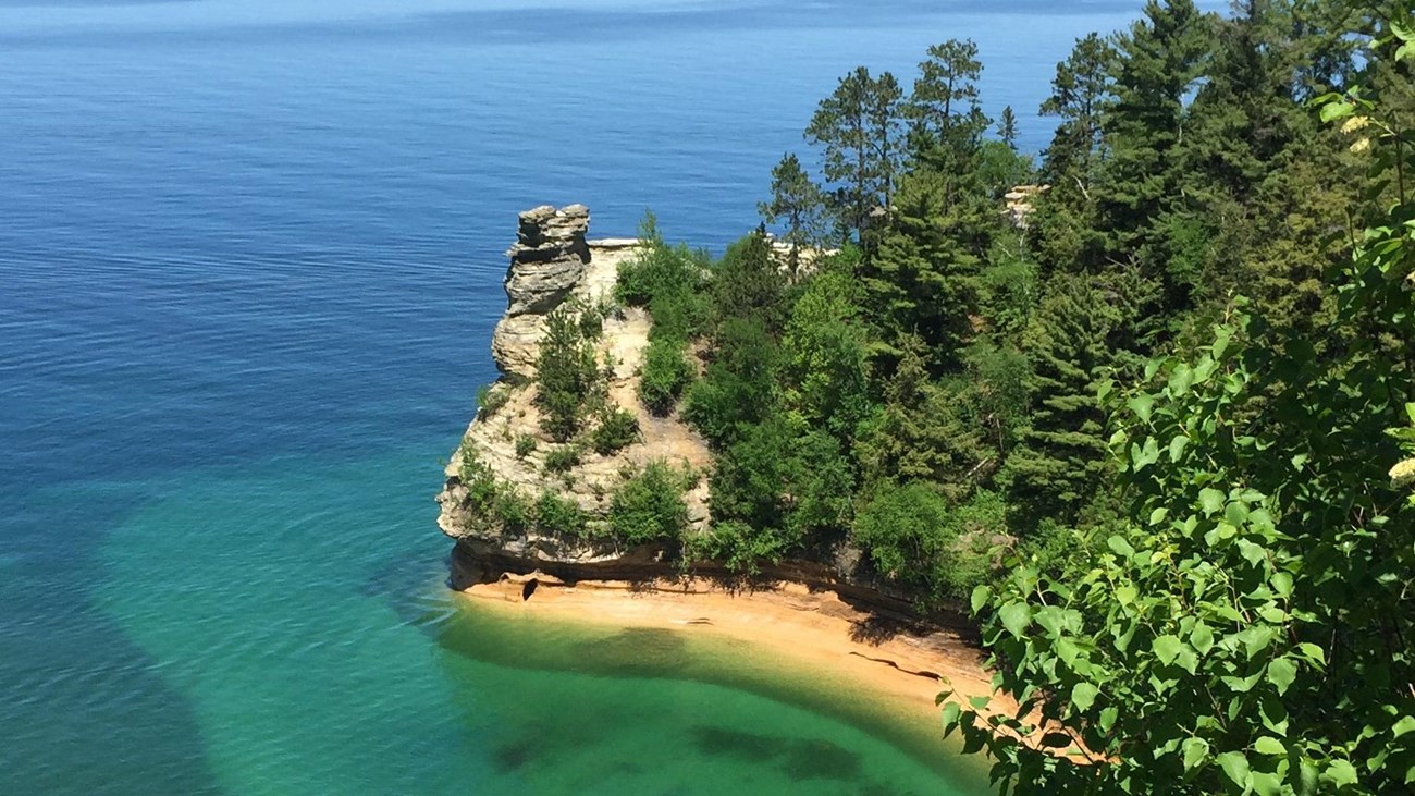
Miners Castle / Miners Beach
You can spend as little or as much time as you like at these two locations - however, they are both doable in an hour. Miners Castle is approximately 11 miles from Munising. Follow Alger County Road H-58 about 5 miles east to Miners Castle Road (H-11). Turn left and go 6 miles north to Miners Castle.
This is the only place where you can drive on the cliffs. The main viewing platform is just a short walk from the parking lot. Allow at least a half hour at Miners Castle if you want to walk to all three viewing platforms. Leashed pets allowed on paved (not dirt) trails, at viewing platforms, and in picnic area.
Once you leave the Miners Castle parking lot, take the first left and drive the road about 1 mile to the Miners Beach parking lot. You can take a quick walk out to the beach just to see the view or spend more time there. Allow at least a half hour if you want to walk west down the beach to Miners River and back. Leashed pets allowed on beach and in water.
COMING FROM GRAND MARAIS: (east side of the park)
Sable Falls / Sable Beach
Drive about 1 mile west of the town of Grand Marais on Alger County Road H-58 to the Sable Falls parking lot. A short walk from the parking lot leads to a long staircase of 168 steps down to the main falls viewing platform.
After viewing the falls, continue on the trail along Sable Creek for another 1/4 mile out to Sable Beach. Enjoy the views of the Grand Sable Dunes towering to the left and the expanse of Lake Superior ahead. Leashed pets allowed.
Grand Sable Dunes Trail
The 0.3 mile trail (one way) to the Grand Sable Dunes also begins in the Sable Falls area. Park at the Sable Falls parking lot and walk towards the falls. The intersection of the Grand Sable Dunes Trail begins near the top of the falls. The trail goes through an old homestead field, across Sable Creek, through a forested dune ecosystem, and ends on top of the dunes.
Once at the top, walk a short distance to the right for a spectacular view of Lake Superior. The trail is fairly level, but there are some uphill sections of walking in sand. Return to the parking lot the way you came. Pets are not allowed on the Grand Sable Dunes Trail.
Log Slide
The Log Slide area highlights the logging history of this area and provides a stunning view of the Grand Sable Dunes. Drive approximately 7 miles west of Grand Marais on Alger County Road H-58, then 1 mile north on Log Slide Road to the parking lot. Walk the short path towards the dunes and read the interpretive signs along the way.
At the intersection of the North Country Trail you can climb the large dune ahead to get various views. Those who don't want to climb in sand can turn left on the North Country Trail and walk just a few yards to the level spur trail heading to the right (at the end of the wooden fence).
Walk out to the edge of the dune for great views of the sand dunes to the right and the Au Sable Lighthouse to the left. Take care not to get too close to the dune edge. Watch for poison ivy along the trail. Pets are not allowed in the Log Slide area or nearby dunes.
Details
Duration
1-1 Hours
Activity
Scenic Driving
Scenic viewing of the park's natural wonders is the focus of this self-guided auto tour. Suggestions for what can be easily seen with just an hour's time.
Pets Allowed
Yes with Restrictions
Where pets are allowed is mentioned in the text. Not all areas listed allow pets.
Activity Fee
No
There is an entrance fee for the park - but no other special fee.
Location
Locations at each end of the park
All of the locations listed can be found on the official park map. All are easily accessible by vehicle and involve fairly short walks.
Reservations
No
Season
Summer, Fall
Access to most of these places is available only when there is no snow closing the roads; generally summer and fall.
Accessibility Information
Wheelchair accessible places:
Sand Point Marsh Trail
Sand Point Beach (with a Mobi mat)
Munising Falls (paved trail to falls, flush toilet)
Miners Castle (top two viewing platforms)
Miners Beach (short trail from parking lot to top of beach stairs)
Sand Point Marsh Trail
Sand Point Beach (with a Mobi mat)
Munising Falls (paved trail to falls, flush toilet)
Miners Castle (top two viewing platforms)
Miners Beach (short trail from parking lot to top of beach stairs)