Last updated: April 4, 2025
Thing to Do
Natchez Civil War Sites Driving Tour
Take a driving tour of Civil War sites in Natchez, while moving at your own pace and in your own car. Your voyage will wind you through historic Natchez, highlighting only some of the more important sites relevant to the Civil War and the Federal occupation of Natchez. Unlike some other Southern cities, Natchez emerged from the conflict relatively unscathed and today, contains one of the greatest collections of antebellum architecture in the nation.
Details
Duration
75 Minutes
Activity
Self-Guided Tours - Auto
Pets Allowed
Yes
Activity Fee
No
Entrance fees may apply, see Fees & Passes information.
Location
Natchez Historic District
This activity is a vehicle-based exploration of a portion of the historic sites in Natchez. Various sites on this tour are privately owned. Please respect private property and observe these sites from the street.
Reservations
No
Time of Day
Day
Accessibility Information
This scenic drive does not require exiting your vehicle.
Site 1: Natchez Visitor Center
Your driving tour of Civil War sites in Natchez begins at the Natchez Visitor Center which contains exhibits about regional history.
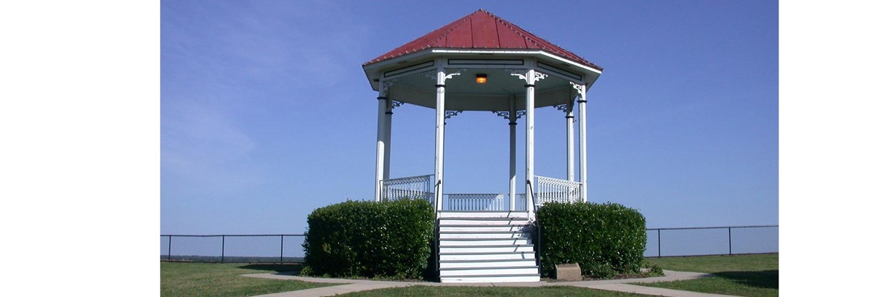
From the Natchez Visitor Center parking lot head southeast toward South Canal Street. Turn left onto South Canal Street and drive .66 miles and turn left onto Main Street and drive .06 miles. Turn left onto South Broadway Street and drive .03 miles. The Gazebo at Bluff Park will be on the right.

Historic Natchez Foundation
On April 30, 1865, to commemorate the assassination of President Lincoln, a procession of mourning moved through the streets of Natchez. Federal troops and Natchez citizens gathered around the bandsand in Bluff Park and listened to a eulogy presented by Mr. Dillingham of Maine, a U. S. Treasury agent.
Start out going southwest on South Broadway for .06 miles. Take the first right onto Silver Street and proceed down the hill, when you reach the bottom you have arrived at Natchez Under-The-Hill.

Historic Natchez Foundation
Site 3: Natchez Under-The-Hill
On July 13, 1863, Federal troops, under the command of Brig. General Thomas Ransom, landed at Natchez Under-The-Hill and occupied the city without opposition. In his official report, Ransom noted "the citizens were completely surprised and hardly realized our design until the place was fully occupied and picketed."
Start out going southwest on Silver Street for .50 miles. Take the first left onto Washington Street and drive .06 miles. Turn left onto South Broadway Street and drive .06 miles and take the first left onto Orleans Street. The Rosalie Mansion is on the right.

Historic Natchez Foundation
Union officers established their headquarters at Rosalie, the classical revival home resting atop the bluffs. Members of the Wilson family continued to occupy the second floor of the house while Federal officers lived and worked downstairs.
Start out heading southeast on Orleans Street toward South Canal Street for .06 miles. Turn left onto South Canal Street and drive .57 miles. When you come to the North Canal Street and Madison Street intersection you have reached the site of former Fort McPherson.
Historic Natchez Foundation
Soon after their arrival, Federal troops began the creation of Fort McPherson, a large earthwork in the northern suburbs of the city. Designed by Capt. Peter Hains of the Engineering Corps, the fortification could accommodate 5,000 troops and provided an unobstructed view of the river and surrounding countryside.
Start out by going northwest on Madison Street towards Linton Avenue for .11 miles. Take the 2nd right onto Clifton Avenue and drive .13 miles to the end of the street.

Historic Natchez Foundation
Federal troops destroyed this palatial home of wealthy Natchezians Frank and Charlotte Surget, ostensibly because it impeded the construction of Fort McPherson. After touring the property before its demolition, Union Gen. Thomas Kilby Smith remarked that "one continuously wonders that such a paradise could be created here on earth."
Start out going southwest on Clifton Avenue towards Mulberry Street for .09 miles. Take the 1st left onto Mulberry Street and drive .08 miles. Take the 2nd left onto Linton Avenue and drive .31 miles. Take a slight left turn onto Maple Street and drive .04 miles. Turn slight left to stay on Maple Street and drive .26 miles. The site of the former Marine Hospital is on the right.

Historic Natchez Foundation
Designed by Robert Mills, architect of the Washington Monument, the Marine Hospital was one of the thirty such structures across the United States. Federal officers transferred many soldiers who had survived the Vicksburg campaign, to the facility for medical care and recuperation.
Start out going North on Maple Street toward National Cemetery for .01 miles. Take a slight left turn onto Cemetery Road and drive .09 miles. The Natchez city cemetery is on the right.

Historic Natchez Foundation
Laid out in 1822, the Natchez city cemetery has been described as one of the most interesting and beautiful in the South. The cemetery is the final resting place for many Confederate dead.
Start out going North on Cemetery Road for .31 miles. The Gardens is on the right.

Historic Natchez Foundation
Due to its close proximity to the Marine hospital and city cemetery, Federal troops used this 18th century house as a medical facility.
Start out going north on Cemetery Road for .15 miles. The Natchez National Cemetery is the right.

Historic Natchez Foundation
The Federal government purchased the original 11 acres site from local residents in 1866 although some of the earliest interments date from the 1850s. Notable graves include those of Wilson Brown, a former slave and Medal of Honor recipient, two Buffalo Soldiers, and members of the 58th U. S. Colored Soldiers.
Start out going south on Cemetery Road for .55 miles. Take slight right onto Maple Street and drive .46 miles. Turn left onto Oak Street and drive .06 miles. Wigwam is on the left just past Wigwam Alley.

Historic Natchez Foundation
Douglas and Eliza Rivers were evicted from their home, The Wigwam, in the spring of 1864. Federal troops used the home as officer barracks and staff offices. This photo shows members of the 23rd Iowa Infantry on the front porch.
Start out going southeast on Oak Street and take the first left onto Myrtle Avenue and drive for .10 miles. The Towers is on the right.

Historic Natchez Foundation
Site 12: The Towers
Natchez's best example of Italianate architecture, this house served as headquarters for Fort McPherson. Union troops resided there with members of the Fleming family until their eviction in 1864.
Start out going southwest on Myrtle Avenue towards Oak Street for .10 miles. Take the 1st left onto Oak Street and drive .19 miles. Take the 3rd right onto North Union Street and drive .04 miles. The Burn is on the right.

Historic Natchez Foundation
The earliest purely Greek Revival mansion in Natchez, The Burn served as offices for the Engineering Department responsible for designing and constructing Fort McPherson. Prior to the occupation, The Burn was home to the John Walworth family.
Start out going southwest on North Union Street for .09 miles. Shields Town House is on the left.

Historic Natchez Foundation
The former owner of the Natchez Foundry, Maurice Lisle built this house in late 1850s. Lisle sold the foundry in 1858 and became a gas fitter, installing gas pipes and lines in scores of Natchez houses and businesses. The Union Army hired Lisle to assist in the construction of a water works inside Fort McPherson.
Start out going southwest on North Union Street for .02 miles. Take the first right onto B Street and drive for .07 miles. Take the first left onto North Commerce Street and drive .14 miles. Take the 2nd right onto Monroe Street and drive .15 miles. Take the 1st left onto North Wall Street and drive for .08 miles. Choctaw is on the right just past High Street.

Historic Natchez Foundation
Federal troops occupied the home of George Malin Davis, a Natchez lawyer and rabid secessionist known as a "fire eater." Family legend holds that troops picked the jeweled eyes of the inlaid birds from a valuable center table.
Start out going southwest on North Wall Street toward Jefferson Street for .05 miles. Take the 1st right onto Jefferson Street and drive .07 miles. Take the first right onto North Canal Street and drive .07 miles. Take the first right onto High Street and drive .22 miles. Stanton Hall is on the left just past North Pearl Street.

Historic Natchez Foundation
Stanton Hall is one of the great houses of the American South. In 1857, Frederick Stanton died shortly after the house was completed. Stanton's widow and family continued to occupy the opulent mansion throughout the 19th century.
Start out going southeast on High Street toward North Union Street for .21 miles. Turn right onto Franklin Street/US-84 Bus E/US-61 Bus N. Continue to follow US-84 Bus E/US-61 Bus N for .93 miles. Turn left onto Liberty Road and drive .07 miles. Turn left onto St. Catherine St/US-84 Bus/US-61 Bus S and drive .06 miles. Forks of the Road is on the left before you reach Junkin Street.

Historic Natchez Foundation
Prior to the Civil War, Forks of the Road was the second-largest slave market in the Deep South. After the Federal occupation of Natchez, members of the 14th Wisconsin and the 58th U. S. Colored Troops worked throughout the night to destroy the slave pens. The destruction of the market symbolized the end of slavery in the Natchez District.
Start out going west on St. Catherine Street/US-84 Bus W/US-61 Bus S toward Rembert Street for .01 miles. Take the 1st left onto Junkin Street and drive .09 miles. Take the 1st left into East Franklin Street/US-84 Bus E/US-61 Bus N and drive .08 miles. Take the first right to stay on East Franklin Street and drive .02 miles. Turn left to stay on East Franklin Street and drive .07 miles. East Franklin becomes Liberty Road, continue on Liberty Road for .62 miles. Turn left onto Old Pond Road and drive .05 miles. Take the 2nd left onto Oakhurst Drive and drive .07 miles. Oakland is on the right. If you reach Bayou Lane you’ve gone about .1 miles too far.

Historic Natchez Foundation
The home of John and Katherine Minor, this house was often referred to as the Union Hotel, due to the fact that the owners frequently entertained Federal officers. A member of a prominent slave-owning family, Katherine Minor once referred to herself as an "abolitionist at heart."
Start out going southeast on Oakhurst Drive toward Old Pond Road for .07 miles. Turn right onto Old Pond Road and drive .04 miles. Take the first right onto Liberty Road and drive for .62 miles. Liberty Road becomes East Franklin Street, continue on East Franklin Street for .04 miles. Take a slight left onto Main Street and drive .32 miles. Main Street turns into John A. Quitman Blvd., continue on John A. Quitman Blvd for .15 miles. Monmouth is on the right. If you reach East Franklin Street you’ve gone about .1 miles too far.
Site 19: Monmouth
Members of the 12th and 14th Wisconsin and 28th Illinois Infantry camped on the lawn of Monmouth, the former home of General John Quitman, once governor of the State of Mississippi and a Mexican war hero, who had died in 1858. Quitman's daughters, who had married Confederate officers, continued to reside there during the Federal occupation.
Start out going east on John A. Quitman Blvd. Take the first right onto Melrose Avenue and drive for .19 miles. Turn left onto Conner Circle. Linden is .04 miles ahead.

Historic Natchez Foundation
Jane Gustine Boyd Conner is often referred to as Natchez's "Mother of the Confederacy," as she sent all five sons and three sons-in-law into the Confederate ranks. The war took a heavy toll on Jane Conner's family; she would lose one son, a son-in-law, a daughter-in-law, a sister-in-law, and seven grandchildren during the conflict.
Start out going northwest on Conner Circle for .04 miles. Turn left onto Melrose Avenue which will become Melrose Montebello Parkway and drive .40 miles. Melrose is on the left.

Historic Natchez Foundation
Although John McMurran, the builder of Melrose, was considered to be a Union man, his son, John Jr., joined Quitman's Light Artillery, a Confederate unit. After the occupation of Natchez, Federal troops set up a picket line at McMurran's front gate while members of the 58th U. S. Colored Troops regularly drilled on the front meadow, and McMurran was shot in the head while coming home from his law office one evening. He lost an eye but survived.
Start out going north on Melrose Montebello Parkway for .01 miles. Take the 1st left onto Ratcliff Place and drive .07 miles. Take the 2nd left onto Armstrong Street and drive .07 miles. Take the first right onto Duncan Avenue and drive .22 miles. Auburn is on the left.

Historic Natchez Foundation
Completed in 1812, Auburn was home to Stephen Duncan, widely recognized as one of the wealthiest planters in the South on the eve of the Civil War. In September 1863, the staunch Unionist and his family boarded the Forest Rose, a Union gunboat that had been put at their disposal. Duncan and his family lived in New York City for the remainder of the war.
Start out going west on Duncan Avenue toward Auburn Avenue for .44 miles. Turn left onto Homochitto Street and drive .02 miles. Hope Farm is on the left.

Historic Natchez Foundation
During the war, this house was home to the Elias Montgomery family. Three of the Montgomery sons would fight for the Confederacy, including Eli, Jr., age 14. Young Eli appears to have died in a Lauderdale Springs Hospital before seeing battle. He is buried in the Natchez City Cemetery with a tombstone emblazoned with the words, "Victim of War."
Start out going north on Homochitto Street for .31 miles. Dunleith is on the left .2 miles past Dunleith Street.

Historic Natchez Foundation
The only remaining house in Mississippi with an encircling colonnade, Dunleith was built by Charles Dahlgreen, who raised two infantry units for service in the Confederacy. Dahlgreen's brother, John, however, became an admiral in the Union navy, a case of brother pitted against brother. During the Civil War, the Confederate sympathizer, Alfred Vidal Davis and his family resided at Dunleith.
Start out going northwest on Homochitto Street for .09 miles. Twin Oaks is on the right just past Arlington Avenue.

Historic Natchez Foundation
Charles DuBuisson built the main portion of Twin Oaks in the 1850s, although sections of the house are believed to be much earlier. DuBuisson was a professor of classics at Jefferson College, and later, practiced law in Natchez. His son, also named Charles, was a corporal in the First Mississippi Light Artillery and later, served in Wirt Adam's regiment of the Mississippi Cavalry.
Start out going north on Homochitto Street for .33 miles. Stay straight to go onto Orleans Street and drive .28 miles. Take the 2nd right onto South Pearl Street and drive for .01 miles. Pleasant Hill is on the left. If you reach Washington Street you’ve gone a little too far.

Historic Natchez Foundation
This raised Greek Revival house was moved to its present location in the 1850s to make way for the construction of Magnolia Hall. During the war, members of the prominent Postlethwaite family, many of whom fought for the Confederacy, lived at Pleasant Hill.
Start out going northeast on South Pearl Street towards Washington Street for .08 miles. Magnolia Hall is on the right just past Washington Street. If you reach State Street you’ve gone a little too far.

Historic Natchez Foundation
Considered to be the last great mansion built in Natchez prior to the war, Magnolia Hall was home to the Henderson family. In May, 1864, Maj. Christensen, Chief of Staff to General Canby, and his fellow officers occupied the mansion. According to family letters, the Union soldiers "were well-behaved, sang well and liked to dance."
Start out going northeast on South Pearl Street for .14 miles. Take the 2nd left onto Main Street and drive for .08 miles. Take the 1st left onto South Wall Street and drive .09 miles. The Courthouse is on the left just past Market Street. If you reach Washington Street you’ve gone a little too far.

Historic Natchez Foundation
Since its construction in 1820, this building has been the seat of Adams County government. It was remodeled in the 1920s. Photographers captured images, such as this one, of Union troops milling about the grounds.
Start out going southwest on South Wall Street for .07 miles. Take the first right onto Washington Street and drive .07 miles. Take the first right onto South Canal Street and drive for .23 miles. Take the 2nd right onto Franklin Street and drive .07 miles. Take the first right onto North Wall Street and drive .15 miles. Mercer House is on the right just past Market Street.

Historic Natchez Foundation
The design of this house is attributed to Levi Weeks, an accomplished New York architect active in Natchez in the early 19th century. Later occupied by wealthy physician and planter, William Newton Mercer, the house was occupied by Federal troops who are depicted on the front steps in this photograph.
Start out going southwest on South Wall Street for .07 miles. Texada is on the right just past State Street. If you reach Washington Street you’ve gone a little too far.

Historic Natchez Foundation
Built between 1793 and 1805 and considered the earliest brick house remaining in the Old Southwest Territory, Texada was appropriated by Federal troops in 1865. Lt. Theodore D. Johnson issued the order which specified that "all the furniture would be retained in the house."
End of tour