Last updated: October 19, 2021
Thing to Do
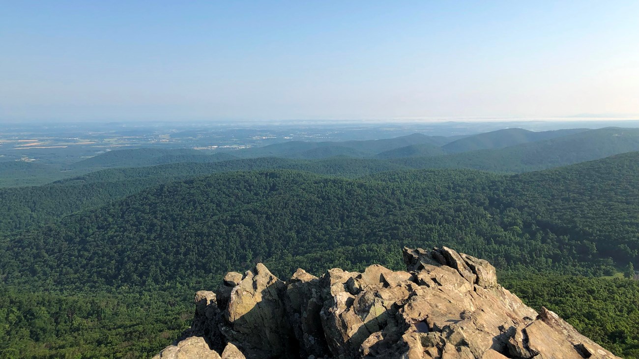
Hike the Humpback Rocks Trail (Milepost 6.0)
NPS
Once an important landmark used by drovers and merchants to gauge their progress as they traveled along the historic Howardsville Turnpike, Humpback Rocks is now one of the most popular hiking destinations along the Virginia section of the Blue Ridge Parkway. The short but strenuous one-mile hike up to The Rocks rewards hikers with spectacular views of the Rockfish and Shenandoah Valleys and glimpses of the Parkway as it winds its way through the forest below.
This is a fun and rewarding hike that will be sure to get your heart pumping! The trail is steep and quite rocky in places so be sure to watch your step and have appropriate footwear.
The trail is marked with a blue-blaze, on extremely popular trails like Humpback Rocks it is especially important that trail users remain on a treadway that has been specifically designed and constructed to handle high volumes of trail traffic. Unapproved trails cause and/or exacerbate the effects of erosion and can have other damaging impacts on the landscape and the environment
19th Century Carvings
When you reach The Rocks, see if you can find a pair of names carved in stone by members of two local families in 1875 and 1894. And then ponder this question: Are these carvings fascinating touchstones to a distant past? Or are they enduring examples of graffiti that continue to disfigure the natural landscape?
Additional Trails
Be sure to check out the many other hiking options that also begin from this trailhead, including the Jack Albright-Appalachian Trail Loop (3.5 miles), the Humpback Rocks – Appalachian Trail Loop (4.0 miles) and the Humpback Rocks – Appalachian Trail / Humpback Mountain - Humpback Rocks Picnic Area Out-And-Back (7.8 miles).
Alternative Starting Point
Consider starting your hike from the Humpback Rocks Visitor Center (Milepost 5.8) and take a “Hike with History” along the Blue Ridge Parkway’s Mountain Farm Trail This will add .8 miles and approximately 30 minutes to the distance and duration of the hike.
Details
Duration
1-3 Hours
Activity
Hiking
The trail begins at the south end of the Humpback Gap Parking Lot (Milepost 6.0).
0.0 Begin steep ascent, passing several benches along the way
0.4 Reach intersection. To the left, an unblazed “social” trail heads uphill. To the right, the blue-blazed Humpback Rocks Trail heads slightly downhill to the right. ***Please bear right and stay on the official blue-blazed trail***.
0.5 After slight descent, begin ascent on impressive series of earth-and-log trail steps
0.7 Continue ascent on series of stone steps
0.9 Reach intersection. Humpback Rocks can be reached via an 800’ spur trail to the left. Pay close attention to your location as you enter this area. The area is crisscrossed by social trails and you will want to locate the blue-blazed trail for your return trip. Use caution when traversing the exposed rocks. Continuing straight at the intersection leads to the summit of Humpback Mountain (1.0 mile) and the Humpback Rocks Picnic Area (2.9 miles)
Be sure to check out the many other hiking options that also begin from this trailhead, including the Jack Albright-Appalachian Trail Loop (3.5 miles), the Humpback Rocks – Appalachian Trail Loop (4.0 miles) and the Humpback Rocks – Appalachian Trail / Humpback Mountain - Humpback Rocks Picnic Area Out-And-Back (7.8 miles).
Pets Allowed
Yes
Pets must be kept on a 6 foot lead at all times while in the park.
Activity Fee
No
Entrance fees may apply, see Fees & Passes information.
Location
Humpback Rocks
Visitors can choose to begin the hike at the Humpback Rocks visitor center to view the short Mountain Farm Trail prior to beginning the ascent. Otherwise there is a parking lot at the trailhead at mile marker 6.
Reservations
No
Accessibility Information
The Humpback Rocks Trail is not handicap accessible due to the uneven and sometimes extremely rocky trail bed. Porta-johns, a single picnic table, and a trash can are located at the trailhead.