Last updated: November 8, 2024
Thing to Do
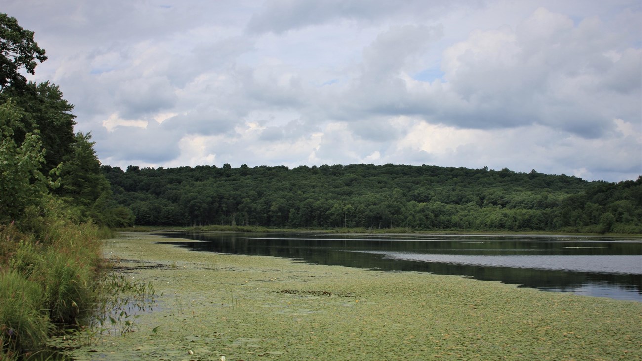
Hike the Cobey Pond Trail
NPS
Spend an hour on this relatively easy hike around the picturesque Cobey Pond. The first quarter mile (400m) of the trail is on a moderate incline through the forest up to the pond. Keep right at the fork to go straight to the Cobey Pond. Pause on the dock or stand on the spillway to take in a beautiful view of the water, surrounded by peaceful forest. As you walk around the water, observe the bubbling brooks and quiet streams feeding into pond, and waterfowl and wildlife that call the place home.
Please note that there are no trail markers and the trail splits several times. Once reaching the pond, go right for the slightly longer route, then keep left to hike along the pond shore. The trail will split again, with the left following the shore and the right going through the woods back to the trailhead. Elevation gain is approximately 245 feet (75m). Be mindful of potentially wet, muddy conditions and ankle-tall grass.
This trail is located on Pennsylvania State Game Lands 316 and is owned and managed by the Pennsylvania Game Commission. There are no restrooms available. Fires, camping, and use of motor vehicles are prohibited. Please see the Pennsylvania State Game Lands page for more detail on land use regulations.
Parking
Parking is available at two spots. A very small gravel parking area with approximately 5 parking spots is located right off Masthope Plank Road. Parking in this lot is not recommended. Instead, keep left onto the gravel road and follow the road about half a mile (800m). A larger dirt parking lot able to accommodate 15 vehicles will be at the end of the road. The trail starts on the other side of the locked gate.
Safety
This land is owned by the Pennsylvania Game Commission. For safety, please wear bright or fluorescent orange or pink to increase your visibility while hiking in these lawful hunting areas.
This trail is not regularly maintained and parts of the trail may have ankle-high grass. Tall grass and leaf litter are prime habitats for ticks. Please check for ticks on yourself and any pets after hiking, no matter the season.
Pack It In, Pack It Out
Please practice "Leave No Trace" principles and do not litter or leave any waste, including animal waste, behind. Take waste with you and dispose of it properly. There are no trash receptacles available on the trails or at the trailheads, so you must take any trash with you when you leave.
Details
Duration
1-2 Hours
The trail is a little over 2 miles (3.5km) with an elevation gain of approximately 245 feet (75m).
Activity
Backcountry Hiking
Moderately easy trail. Elevation gain is approximately 245 feet (75m), with a moderate incline up to Cobey Pond. Trail around Cobey Pond is relatively flat, but trail is uneven and grassy, with potential for mud and water, especially after rain. Please stay on the trail and practice “Leave No Trace” principles.
Pets Allowed
Yes
Pets are welcome to hike alongside people on the Cobey Pond Trail. However, there are restrictions for the safety of natural resources, wildlife, other visitors, and the pet. Please keep pets on a leash while on the trail and pet waste must be collected by pet owners and carried out. No pet waste bags or trash receptacles are available on the trail, at the trailhead, or at the parking lot. Do not leave pet waste or other litter at the trailhead or parking lots. Be mindful of poison ivy, ticks, and wildlife.
Activity Fee
No
Entrance fees may apply, see Fees & Passes information.
Location
Masthope Plank Road, Masthope, PA
From Narrowsburg:
Cross the Delaware River into Pennsylvania onto Pennsylvania State Route 652. Shortly after, turn south (left) onto Perkins Pond Road/Peggy Runway Road. After approximately 1 mile, turn south (left) on Welcome Lake Road. Please note the name of the road changes to Case Road as you enter the Township of Lackawaxen. Follow Welcome Lake Road approximately 4 miles, then turn east (left) on Masthope Plank Road. Look for the access road about 1 mile in on the left and turn in. You should cross a small bridge.
From Lackawaxen:
From Pennsylvania State Route 590 in Lackawaxen, cross the Lackawaxen River and immediately turn east (right) onto Masthope Plank Road, which follows the Pennsylvania side of the river. Travel approximately 9 miles. Look for the access road on the right side of the road and turn in. You should cross a small bridge.
After you reach the bridge:
After crossing the bridge and you will see a small parking area. Please continue to drive down the gravel road on the left. This somewhat narrow road will continue up for approximately half a mile (800m). The main parking lot and the trailhead are located at the end of this road.
Scroll to bottom of a page for a map.
Reservations
No
Season
Year Round
Please exercise caution and situational awareness with weather conditions while hiking. During all seasons, there is always a risk of ticks. Please check for ticks on yourself and any pets after hiking. Also be especially mindful when hiking during hunting season. Wear bright or flourescent orange or pink.
Time of Day
Day
All trails at Upper Delaware Scenic and Recreational River are day-use only. No backcountry camping is permitted.
Accessibility Information
The trail starts off at a moderate incline for approximately a fourth of a mile (400m) up to Cobey Pond. The trail up to the pond is gravel and approximately 6-8 feet wide. At Cobey Pond, there is a wooden dock visitors can use. This dock does not have walls or railings. The trail around the pond and back to the trailhead varies from tall grass to dirt and leaf litter and on average is 4-5 feet (1.5m) wide. One may encounter rocks, mud, pools of water, and small gaps in the trail. Total elevation gain is approximately 245 feet (75m).

NPS