Last updated: April 24, 2025
Thing to Do
Drive to the Top of Capulin Volcano
Take a drive up a historic road to the top of an extinct cinder cone volcano! The Volcano Road leading to the crater rim is approximately two miles long and takes 10 minutes to drive up. Trailers, towed vehicles, and vehicles over 26 feet in length are prohibited. Because the road has no shoulders, bicycyles and pedestrians are only permitted when the road is closed to vehicle traffic after park hours. Current road conditions are available by calling the monument at 575-278-2201.
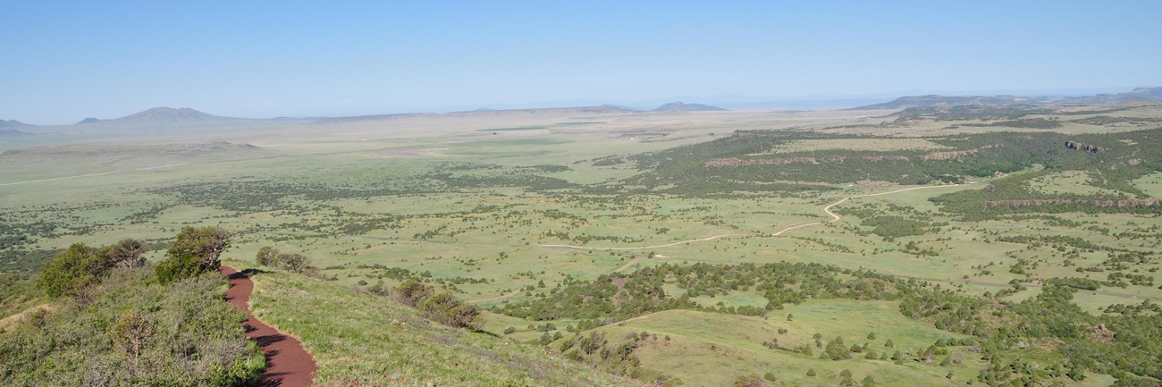
Once at the top of the volcano, choose to enjoy the view from the parking area or hike on some of the trails. The Crater Rim Trail is a steep, paved one mile loop around the rim of the volcano with fantastic views. Signs provide visitors with information about the surrounding features in the Raton-Clayton Volcanic Field. The Crater Vent Trail is a 0.2 mile (one-way) steep, paved trail leading to the bottom of Capulin Volcano's crater. No pets are allowed on either of these trails, though they are welcome on a leash in the parking area.
Once at the top of the volcano, choose to enjoy the view from the parking area or hike on some of the trails. The Crater Rim Trail is a steep, paved one mile loop around the rim of the volcano with fantastic views. Signs provide visitors with information about the surrounding features in the Raton-Clayton Volcanic Field. The Crater Vent Trail is a 0.2 mile (one-way) steep, paved trail leading to the bottom of Capulin Volcano's crater. No pets are allowed on either of these trails, though they are welcome on a leash in the parking area.
Details
Duration
30-120 Minutes
The drive up to the top of the volcano takes about 10 minutes. Once at the top you can spend as much or as little time as you want either enjoying the views or hiking the trails.
Activity
Scenic Driving
Volcano Road is a two mile paved drive that winds around Capulin Volcano to it's summit. Because of it's tight curves and steep nature, no trailers or vehicles over 26 feet are allowed on the road. There is a small parking lot at the top of the road where you can enjoy scenic views of both the surrounding landscape and volcanic crater. Two hiking trails leave from this parking area. The Crater Vent Trail is a quarter mile hike down into the bottom of the crater. The Crater Rim Trail is a mile loop hike around the rim of the crater that provides fantastic views of the Raton-Clayton Volcanic Field.
Age(s)
0-99
All ages are welcome. Take into account the high elevation of the road - 7,300 to 8182 feet elevation (2,225 to 2,494 meters) - when driving up or hiking at the top of the volcano.
Pets Allowed
Yes with Restrictions
Pets are allowed on a leash in the parking area at the top of the volcano. They are not allowed on the Crater Vent Trail or the Crater Rim Trail. Both trails are paved with a material that absorbs the sun's heat and can burn their paws.
Activity Fee
Yes
Entrance fees may apply, see Fees & Passes information.
Location
Top of Volcano Road
Volcano Road can be accessed from the visitor center and winds around the volcano to the top.
Reservations
No
Season
Year Round
Winter is cold with snowstorms and ice common. The road is closed when it's actively snowing or icy, though it is plowed to keep it open though the winter. Mornings often bring freezing fog, which coats the top of the volcano in rime ice. The trails remain open, though they are icy in spots so be aware of hazardous surfaces.
Spring brings variable temperatures and sometimes a late snowstorm. It is usually also very windy.
Summer is warm with temperatures in the 80s and 90s F (27-35 C). In July and August, afternoon thunderstorms that can bring heavy rain and hail are common. Whenever lightning is spotted within a 10 mile radius of the top of the volcano, both the top of the volcano and the road are closed for visitor safety as lightning often strikes the volcano. Heavy rain also sometimes causes cinder slides after which the road is closed to clear the cinders and mud off.
Fall brings cooling temperatures and variable weather.
Time of Day
Day
Volcano Road is open when the Visitor Center is open. The road closes to vehicles going up 30 minutes before the Visitor Center closes to ensure that all cars are down in time. After the road closes to vehicles, pedestrians and bicyclists are welcome to use the road.
Accessibility Information
Service animals are welcome on all trails and roads.
The drive up to the top of the volcano is fully accessible to all vehicles under 26 feet in length, and there is a handicap parking space in the parking area at the top of the volcano. The parking area is a flat paved area with a small ramp to a sidewalk that accesses signs about the view and accessible restrooms. The sidewalk has a 3 foot tall retaining wall around the perimeter for safety.
The Crater Rim Trail is a roughly paved 1 mile loop trail around rim of the crater that is around 3 feet wide and begins and ends with a short staircase. The grade of the trail is 12% in some places with 300 feet of elevation change from the parking area.
The Crater Vent Trail is a roughly paved quarter mile one way trail down into the bottom of the crater that is around 3 feet wide and begins and ends with a short staircase. There is around 100 feet of elevation change along this trail from the parking area.