Last updated: November 22, 2021
Lesson Plan
Landscape Stories Post Trip Activity

- Grade Level:
- Upper Elementary: Third Grade through Fifth Grade
- Subject:
- Science
- Lesson Duration:
- 90 Minutes
- Common Core Standards:
- 4.SL.5, 5.SL.5, 4.W.8
- Additional Standards:
- Next Generation Science Standards
4-ESS1-1
4-ESS2-1 - Thinking Skills:
- Remembering: Recalling or recognizing information ideas, and principles. Understanding: Understand the main idea of material heard, viewed, or read. Interpret or summarize the ideas in own words. Analyzing: Break down a concept or idea into parts and show the relationships among the parts.
Essential Question
How are canyons, natural bridges, and salt flats formed?
Objective
Students will be able to:
• analyze a landscape and make conclusions about how it may have formed.
• define the difference between weathering and erosion
Background
Lesson Overview: In groups, students use their knowledge and experience from the field trip to create landscape stories about Death Valley National Park. Students record their stories using a cartoon strip.
During the field trip, students will learn how features in Death Valley were formed. Salt flats are formed by floodwaters bringing down minerals from the surrounding mountains. The floodwaters pool at the lowest point, Badwater Basin. When those floodwaters dry up, salt is left behind. Additionally, Badwater is a low point because the crust is being pulled apart, causing this area to drop.
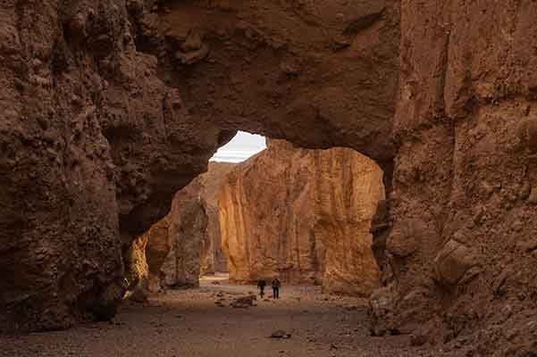
Canyons are formed as water weathers and erodes away the rock, carrying it out of the mouth of the canyon and onto the alluvial fan and valley floor. These canyons are confining canyons—which means that water channels or funnels into narrow sections of the canyon. The water can get deeper and faster in these areas.
Preparation
Printed photos of Death Valley landscapes, one for each group
Cartoon strip worksheet for each student
Materials
Pass out one set of photos to each small group.
Download Landscape Stories Printable Photos
This is the graphic organizer students will use to explain the formation of a landform.
Download Landscape Stories Cartoon Strip
Lesson Hook/Preview
Anticipatory Set
Break students into groups of four or five by counting off or using another method of sorting students into groups. Ask them to recall their trip to Badwater and/or Golden Canyon. In small groups, the students should discuss how canyons and/or the salt flats form.
Procedure
Group Activity
-
Pass out pictures of desert landscapes in Death Valley to the same groups.
-
Ask the students to come up with reasons why the landscape appears the way it does.
-
Project the photo using the provided PowerPoint.
-
When the students have discussed it for about 15 or 20 minutes, have them choose a leader to go in front of their peers and tell their landscape story.
Vocabulary
Weathering: The process of breaking large rocks into smaller rocks over time.
Erosion: The movement of weathered rock and soil from one place to another.
Assessment Materials
Cartoon Strip AssessmentEach student should be provided with a three part cartoon strip. They will draw their landscape story that corresponds with the card they received in three parts (before, during, and how the landscape appears today).
Badwater: In their cartoon strip, students should create three drawings that represent floodwaters from storms bringing down minerals from the mountains, the floodwaters pooling in the bottom of the basin, and the water evaporating, leaving the salt behind.
Golden Canyon: In their cartoon strip, students should create three drawings that represent floodwaters from storms weathering and eroding away at mountains. The students’ drawings should include the movement of water through the canyon. Students may also represent the canyon getting wider and/or deeper as time passes and floods carve more and more rock away.
Natural Bridge: In their cartoon strip, students should create three drawings that represent floodwaters from storms weathering and eroding away at mountains. The students’ drawings should include the movement of water through the canyon. Students should also represent floodwaters carving a hole into a canyon wall which creates the rock bridge formation.
Related Lessons or Education Materials
This lesson plan pairs as a post-trip activity with our geology-focused field trips, such as Dynamic Death Valley.
This lesson plan was developed through the Teacher-Ranger-Teacher program. Please provide us with feedback on this lesson plan using the contact link below. Thank you!
