Lesson Plan
Wheat Farms, Flour Mills, and Railroads: A Web of Interdependence - A Teaching with Historic Places Lesson Plan
- Grade Level:
- Fifth Grade-Twelfth Grade
- Subject:
- Agriculture, History, Westward Expansion
- Duration:
- Variable. Adaptable to teacher and student needs.
- Group Size:
- Up to 36
- Setting:
- indoors or outdoors
- National/State Standards:
- Relevant U.S. History Standards for Grades 5-12: Era 6 - The Development of the Industrial United States (1870 - 1900) Standard 1C; Era 7 - The Emergence of Modern America (1890-1930) Standard 3B
- Keywords:
- Teaching with Historic Places, St. Anthony Falls, Minneapolis, MN history, wheat production, flour processing, transportation history, bonanza farms, Commerce and Industry, Westward Expansion, North Dakota History, Minnesota History, agricultural production, Red River Valley history, flour mills, waterpower, railroad history, Pillsbury Mill Complex, Mill districts, wheat harvesting, lesson plan
Overview
Using the St. Anthony Falls and St. Paul, Minneapolis and Manitoba Railway Company Shops Historic Districts and Bagg Bonanza Farm District, this lesson plan allows students to explain the interdependence of wheat production, flour processing and transportation by analyzing the components involved. Students will use historic maps, readings, photographs and drawings to describe life and work on bonanza farms.Objective(s)
- To explain the interdependence of wheat production, flour processing, and transportation by analyzing the components involved.
- To describe life and work on bonanza farms.
- To seek evidence of industrial interdependence in their own communities and to identify local historic properties reflecting those developments.
Background
Information on how to use a Teaching with Historic Places Lesson Plan can be found here.Materials
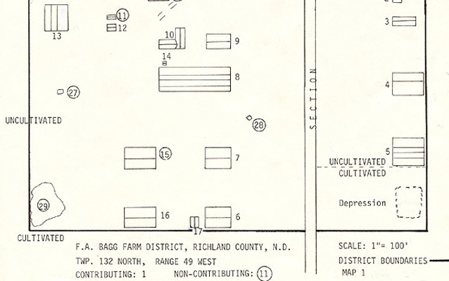
- One map showing Minnesota and North Dakota and the railroad systems that linked them together;
- Three readings about flour milling, wheat farming, and railroads;
- Five photographs of the flour milling districts in Minneapolis, wheat harvesting, and a bonanza farm in North Dakota;
- One drawing of a bonanza farm.
Procedure
Wheat Farms, Flour Mills, and Railroads: A Web of Interdependence
Each Teaching with Historic Places lesson plan contains the following teaching activities: Getting Started (inquiry question), Setting the Stage (historical background), Locating the Site (maps), Determining the Facts (readings, documents, charts), Visual Evidence (photographs and other graphic documents), and Putting It All Together (activities). See Parts 2-7 for information about how to use these resources.
Click here to go directly to the lesson plan.
Getting Started
Begin this lesson by asking students to discuss possible answers to the inquiry question that accompanies the "Getting Started" image. Provide them with paper print-outs of the image and question, or direct them to the lesson plan website. To facilitate a whole class discussion, you may want to print or scan the image to make an overhead transparency or digital slide. The purpose of this exercise is to engage students' interest in the lesson's topic by raising questions that can be answered as they complete the lesson.
Rather than serving merely as an illustration for the text, the image is a document that plays an integral role in helping students achieve the lesson's objective. To assist students in learning how to "read" visual materials you may want to begin this section by having them complete the Photo Analysis Worksheet for one or more of the photos. The worksheet is appropriate for analyzing both historical and recent photographs and will help students develop a valuable skill.
Getting Started section for this lesson
Setting the Stage
This section is intended to be used, if necessary, as background material. Read this material aloud to students or summarize it, or provide them with paper print-outs, or direct them to the lesson plan website. If students have computers, you can direct them to the page on the website.
Setting the Stage section for this lesson
Locating the Site
Provide students with the maps and questions included in Locating the Site. You can give them paper print-outs or direct them to the lesson plan website. Have students work individually or in small groups to complete the questions. At least one map familiarizes the students with the historic site's location within the country, state or region. Extended captions may be included to provide students with information necessary to answer the questions.
Locating the Site section in this lesson
Determining the Facts
Provide students with copies of the readings, documents and/or charts included in this section or direct them to the lesson plan website. Allow students to work individually or in small groups. The series of questions that accompanies each of these readings is designed to ensure that students have gathered the appropriate facts from the material.
Determining the Facts section for this lesson
Visual Evidence: Images
Distribute the lesson's visual materials among students. Provide them with paper print-outs, or direct them to the lesson plan website. Have the students examine the photographs and answer the related questions. Note that two or more images may be studied together in order to complete the questions. Extended captions may be included to provide students with important information.
Rather than serving merely as illustrations for the text, the images are documents that play an integral role in helping students achieve the lesson's objectives. To assist students in learning how to "read" visual materials, you may want to begin this section by having them complete the Photo Analysis Worksheet for one or more of the photos.
Visual Evidence: Images section for this lesson
Putting It All Together
After students have completed the questions that accompany the maps, readings and visuals, they should be directed to complete one or more of the activities presented below. These activities engage students in a variety of creative exercises that help them synthesize the information they have learned and formulate conclusions. At least one activity leads students to look for places in their community that relate to the topic of the lesson. In this way students learn to make connections between their community and the broader themes of American history they encounter in their studies.
Putting It All Together section for this lesson